

Carl Goeleib Mohr
| Birth | : | 10 Jul 1902 Ramona, Lake County, South Dakota, USA |
| Death | : | 10 Dec 1972 Viborg, Turner County, South Dakota, USA |
| Burial | : | St. Bartholomew's Churchyard, Otford, Sevenoaks District, England |
| Coordinate | : | 51.3123700, 0.1916890 |
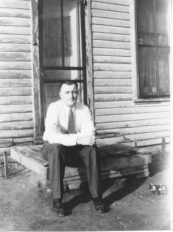
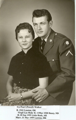
| Description | : | Carl Goeleib Mohr was born 10 Jul 1902 in Ramona, Lake Co., SD to Peter Otto & Katherine Margaret (Lee) Mohr. Carls parents were born in Germany, and he was one of 14 children. In 1929 he moved to Wimbledon, ND where he farmed. He married Hazel Senff 4 Feb 1928 in Cooperstown, ND. They lived around Dazey, Barnes Co., ND until 1942 when they moved to Vermillion, SD, later in 1944 they moved to Centerville, SD, where they stayed most of their married life. Carl worked for Centerville Rendering Co. as a truck driver... Read More |
frequently asked questions (FAQ):
-
Where is Carl Goeleib Mohr's memorial?
Carl Goeleib Mohr's memorial is located at: St. Bartholomew's Churchyard, Otford, Sevenoaks District, England.
-
When did Carl Goeleib Mohr death?
Carl Goeleib Mohr death on 10 Dec 1972 in Viborg, Turner County, South Dakota, USA
-
Where are the coordinates of the Carl Goeleib Mohr's memorial?
Latitude: 51.3123700
Longitude: 0.1916890
Family Members:
Parent

Spouse
Siblings
Children
Flowers:


Nearby Cemetories:
1. St. Bartholomew's Churchyard
Otford, Sevenoaks District, England
Coordinate: 51.3123700, 0.1916890
2. St. Peter and St. Paul's Churchyard
Shoreham, Sevenoaks District, England
Coordinate: 51.3330170, 0.1844590
3. St Mary's
Dunton Green, Sevenoaks District, England
Coordinate: 51.2986100, 0.1632100
4. Greatness Park Cemetery
Sevenoaks, Sevenoaks District, England
Coordinate: 51.2906800, 0.2043260
5. St Mary the Virgin Churchyard
Kemsing, Sevenoaks District, England
Coordinate: 51.3068670, 0.2310220
6. St Peter and St Paul Churchyard
Seal, Sevenoaks District, England
Coordinate: 51.2907080, 0.2223010
7. St Mary the Virgin Churchyard
Riverhead, Sevenoaks District, England
Coordinate: 51.2840040, 0.1707580
8. St Mary's Churchyard Woodlands
West Kingsdown, Sevenoaks District, England
Coordinate: 51.3233700, 0.2428600
9. Sevenoaks War Memorial
Sevenoaks, Sevenoaks District, England
Coordinate: 51.2761078, 0.1927860
10. Chevening Parish Burial Ground
Chevening, Sevenoaks District, England
Coordinate: 51.2987450, 0.1356290
11. St Botolph Churchyard
Chevening, Sevenoaks District, England
Coordinate: 51.2987650, 0.1345180
12. Bluebell Cemetery
Halstead, Sevenoaks District, England
Coordinate: 51.3409718, 0.1409984
13. St Nicholas Churchyard
Sevenoaks, Sevenoaks District, England
Coordinate: 51.2673310, 0.1933100
14. St. Margaret Churchyard
Halstead, Sevenoaks District, England
Coordinate: 51.3350870, 0.1284220
15. St. Lawrence Churchyard
Seal Chart, Sevenoaks District, England
Coordinate: 51.2742910, 0.2537250
16. St Katharine Churchyard
Knockholt, Sevenoaks District, England
Coordinate: 51.3105200, 0.1046060
17. St Mary Churchyard
Sundridge, Sevenoaks District, England
Coordinate: 51.2743360, 0.1292510
18. St Martin Churchyard
Eynsford, Sevenoaks District, England
Coordinate: 51.3675308, 0.2112560
19. Eynsford War Memorial
Eynsford, Sevenoaks District, England
Coordinate: 51.3685875, 0.2135230
20. Christian Fellowship Baptist Churchyard
Eynsford, Sevenoaks District, England
Coordinate: 51.3697548, 0.2145360
21. St Martin of Tours Churchyard
Chelsfield, London Borough of Bromley, England
Coordinate: 51.3557970, 0.1234670
22. St Peter Churchyard
Ightham, Tonbridge and Malling Borough, England
Coordinate: 51.2891680, 0.2858450
23. St Martin Churchyard
Brasted, Sevenoaks District, England
Coordinate: 51.2794480, 0.1043810
24. St Peter and St Paul Churchyard
Farningham, Sevenoaks District, England
Coordinate: 51.3803177, 0.2217920