
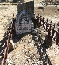
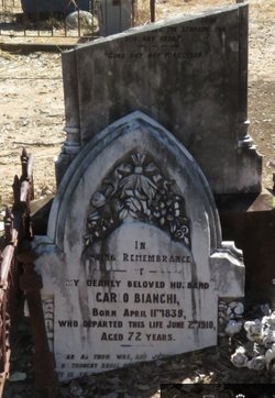
Carlo “Charles” Bianchi
| Birth | : | 11 Apr 1839 Olgiate Comasco, Provincia di Como, Lombardia, Italy |
| Death | : | 2 Jun 1910 Rockhampton, Rockhampton Region, Queensland, Australia |
| Burial | : | St Mary and St Nicholas Churchyard, Leatherhead, Mole Valley District, England |
| Coordinate | : | 51.2925810, -0.3269850 |
| Description | : | Morning Bulletin (Rockhampton, Qld. : 1878 - 1954) Wednesday 8 June 1910 page 6 A Bogantungan correspondent, writing on the 6th instant, says: - "It is my sad duly to chronicle the death of Mr. Carlo Bianchi, of the Commercial Hotel, Bogantungan, at the Rockhampton Hospital, after a long and painful illness. Some months back the deceased was thrown heavily from a buggy while out driving and received severe injuries, the nature of which was not fully known. Being a man who had led a hard life in the bush, he did not wish to seek medical advice, thinking he would... Read More |
frequently asked questions (FAQ):
-
Where is Carlo “Charles” Bianchi's memorial?
Carlo “Charles” Bianchi's memorial is located at: St Mary and St Nicholas Churchyard, Leatherhead, Mole Valley District, England.
-
When did Carlo “Charles” Bianchi death?
Carlo “Charles” Bianchi death on 2 Jun 1910 in Rockhampton, Rockhampton Region, Queensland, Australia
-
Where are the coordinates of the Carlo “Charles” Bianchi's memorial?
Latitude: 51.2925810
Longitude: -0.3269850
Family Members:
Spouse
Children


Flowers:


Nearby Cemetories:
1. St Mary and St Nicholas Churchyard
Leatherhead, Mole Valley District, England
Coordinate: 51.2925810, -0.3269850
2. St Mary Churchyard
Fetcham, Mole Valley District, England
Coordinate: 51.2881290, -0.3525500
3. Randalls Park Cemetery and Crematorium
Leatherhead, Mole Valley District, England
Coordinate: 51.3035290, -0.3469730
4. St Michael Churchyard
Mickleham, Mole Valley District, England
Coordinate: 51.2675150, -0.3233720
5. St Giles Churchyard
Ashtead, Mole Valley District, England
Coordinate: 51.3086540, -0.2900093
6. St Nicolas Parish Churchyard
Great Bookham, Mole Valley District, England
Coordinate: 51.2798220, -0.3739870
7. Yehudi Menuhin International School
Stoke D'Abernon, Elmbridge Borough, England
Coordinate: 51.3059170, -0.3775720
8. St Marys Churchyard
Headley, Mole Valley District, England
Coordinate: 51.2799700, -0.2736100
9. All Saints Churchyard
Little Bookham, Mole Valley District, England
Coordinate: 51.2826900, -0.3864790
10. St Marys Churchyard
Stoke D'Abernon, Elmbridge Borough, England
Coordinate: 51.3139230, -0.3812710
11. Polesden Lacey Estate Pet Cemetery
Great Bookham, Mole Valley District, England
Coordinate: 51.2592260, -0.3718640
12. Polesden Lacey Estate
Great Bookham, Mole Valley District, England
Coordinate: 51.2591310, -0.3718630
13. St Lawrence Churchyard
Effingham, Guildford Borough, England
Coordinate: 51.2712010, -0.3984180
14. Epsom Cemetery
Epsom, Epsom and Ewell Borough, England
Coordinate: 51.3198040, -0.2594180
15. Cobham Municipal Cemetery
Cobham, Elmbridge Borough, England
Coordinate: 51.3204240, -0.3954060
16. Saint Peter's Church
Walton-on-the-Hill, Reigate and Banstead Borough, England
Coordinate: 51.2817810, -0.2467230
17. St. Barnabas Churchyard
Ranmore Common, Mole Valley District, England
Coordinate: 51.2419730, -0.3602730
18. Dorking Cemetery
Dorking, Mole Valley District, England
Coordinate: 51.2365646, -0.3189580
19. St. Martin of Tours Churchyard
Epsom, Epsom and Ewell Borough, England
Coordinate: 51.3306847, -0.2593640
20. St Martin Churchyard
Dorking, Mole Valley District, England
Coordinate: 51.2326360, -0.3320140
21. Deepdene Mausoleum
Dorking, Mole Valley District, England
Coordinate: 51.2307590, -0.3206630
22. St Andrew Churchyard
Cobham, Elmbridge Borough, England
Coordinate: 51.3259580, -0.4114970
23. Holy Trinity Churchyard
Claygate, Elmbridge Borough, England
Coordinate: 51.3588960, -0.3394210
24. St Mary the Virgin Churchyard
Chessington, Royal Borough of Kingston upon Thames, England
Coordinate: 51.3580840, -0.3001320