
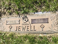
| Birth | : | 9 Nov 1874 Cassville, Grant County, Wisconsin, USA |
| Death | : | 27 Apr 1961 Sioux City, Woodbury County, Iowa, USA |
| Burial | : | Macclesfield Crematorium, Macclesfield, Cheshire East Unitary Authority, England |
| Coordinate | : | 53.2656340, -2.1373290 |
| Plot | : | Blk 10, lot 82, grv 5 |
| Description | : | Mrs. Caroline Jewell, 86, a former resident of Cherokee for many years, died Thursday evening April 27 in Sioux City where she has lived for several years. She is survived by one son Earl M. Jewell, Sioux City, one brother, Jacob G. Huber, also of Sioux City and one sister, Mrs. Elsie Corrington of Los Angeles, six grandchildren and fourteen great-grandchildren. She was preceded in death by her husband, Herbert M. Jewell in 1950 and by a son, Floyd W. Jewell in 1960. Mrs. Jewell was a member of Memorial Presbyterian Church and Carnation Chapter No. 165... Read More |
frequently asked questions (FAQ):
-
Where is Caroline “Lena” Huber Jewell's memorial?
Caroline “Lena” Huber Jewell's memorial is located at: Macclesfield Crematorium, Macclesfield, Cheshire East Unitary Authority, England.
-
When did Caroline “Lena” Huber Jewell death?
Caroline “Lena” Huber Jewell death on 27 Apr 1961 in Sioux City, Woodbury County, Iowa, USA
-
Where are the coordinates of the Caroline “Lena” Huber Jewell's memorial?
Latitude: 53.2656340
Longitude: -2.1373290
Family Members:
Parent

Spouse
Siblings
Children
Flowers:


Nearby Cemetories:
1. Macclesfield Crematorium
Macclesfield, Cheshire East Unitary Authority, England
Coordinate: 53.2656340, -2.1373290
2. Macclesfield Cemetery
Macclesfield, Cheshire East Unitary Authority, England
Coordinate: 53.2652260, -2.1376130
3. St. Alban's Churchyard
Macclesfield, Cheshire East Unitary Authority, England
Coordinate: 53.2599190, -2.1339940
4. St. Michael's & All Angels Churchyard
Macclesfield, Cheshire East Unitary Authority, England
Coordinate: 53.2572950, -2.1195970
5. St Paul Churchyard
Macclesfield, Cheshire East Unitary Authority, England
Coordinate: 53.2574100, -2.1192400
6. Holy Trinity Churchyard
Hurdsfield, Cheshire East Unitary Authority, England
Coordinate: 53.2647300, -2.1124600
7. St Peter Churchyard
Prestbury, Cheshire East Unitary Authority, England
Coordinate: 53.2892070, -2.1505100
8. St Thomas Churchyard
Henbury, Cheshire East Unitary Authority, England
Coordinate: 53.2594420, -2.1792260
9. Brunswick Wesleyan Methodist Chapel Chapelyard
Sutton (Macclesfield), Cheshire East Unitary Authority, England
Coordinate: 53.2359570, -2.1213260
10. St James Churchyard
Sutton (Macclesfield), Cheshire East Unitary Authority, England
Coordinate: 53.2378520, -2.1063910
11. St John the Baptist Churchyard
Bollington, Cheshire East Unitary Authority, England
Coordinate: 53.2969600, -2.0926100
12. Wesleyan Chapel Chapelyard
Rainow, Cheshire East Unitary Authority, England
Coordinate: 53.2835470, -2.0709590
13. St James Churchyard
Gawsworth, Cheshire East Unitary Authority, England
Coordinate: 53.2241390, -2.1661520
14. Maggoty Wood
Gawsworth, Cheshire East Unitary Authority, England
Coordinate: 53.2234560, -2.1652510
15. St. Christopher Churchyard
Pott Shrigley, Cheshire East Unitary Authority, England
Coordinate: 53.3096500, -2.0842900
16. Alderley Park
Nether Alderley, Cheshire East Unitary Authority, England
Coordinate: 53.2715440, -2.2352370
17. St . Stephen's Church Forest Chapel
Macclesfield Forest, Cheshire East Unitary Authority, England
Coordinate: 53.2462260, -2.0399720
18. St Marys Churchyard
Nether Alderley, Cheshire East Unitary Authority, England
Coordinate: 53.2820200, -2.2388500
19. All Saints Churchyard
Siddington, Cheshire East Unitary Authority, England
Coordinate: 53.2342820, -2.2317890
20. St. John the Evangelist Churchyard
Cheshire East Unitary Authority, England
Coordinate: 53.2862960, -2.0256440
21. Dean Row Chapelyard
Wilmslow, Cheshire East Unitary Authority, England
Coordinate: 53.3304820, -2.1951770
22. Christ Church Churchyard
Woodford, Metropolitan Borough of Stockport, England
Coordinate: 53.3375900, -2.1733800
23. Alderley Edge Cemetery
Alderley Edge, Cheshire East Unitary Authority, England
Coordinate: 53.2995180, -2.2530880
24. St James and St Paul Churchyard
Marton, Cheshire East Unitary Authority, England
Coordinate: 53.2087950, -2.2257460