
| Memorials | : | 0 |
| Location | : | Pott Shrigley, Cheshire East Unitary Authority, England |
| Coordinate | : | 53.3096500, -2.0842900 |
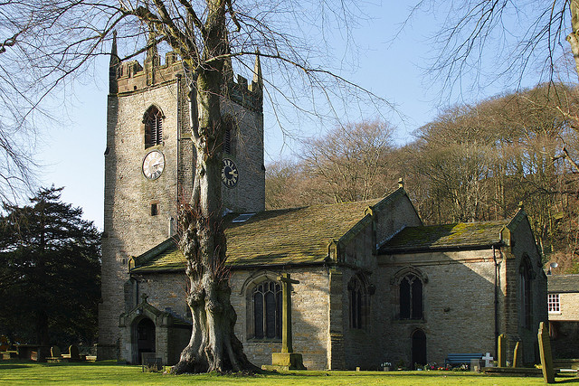
| Description | : | St. Christopher's Church is a Grade I listed building constructed in millstone grit (a local stone), with a tower parapet and window and door framings in grey sandstone. The roof is covered with stone slabs quarried in nearby Kerridge. St Christopher's was originally a chapel connected to the parish of Prestbury. It is thought that the church was founded in the late 14th century and completed in its present form by the construction of the Downes Chantry Chapel by Geoffrey Downes in the late fifteenth century. A list of ministers is known from 1502 and the baptism registers commence in... Read More |
frequently asked questions (FAQ):
-
Where is St. Christopher Churchyard?
St. Christopher Churchyard is located at Shrigley Road Pott Shrigley, Cheshire East Unitary Authority ,Cheshire , SK10 5RTEngland.
-
St. Christopher Churchyard cemetery's updated grave count on graveviews.com?
0 memorials
-
Where are the coordinates of the St. Christopher Churchyard?
Latitude: 53.3096500
Longitude: -2.0842900
Nearby Cemetories:
1. St John the Baptist Churchyard
Bollington, Cheshire East Unitary Authority, England
Coordinate: 53.2969600, -2.0926100
2. Wesleyan Chapel Chapelyard
Rainow, Cheshire East Unitary Authority, England
Coordinate: 53.2835470, -2.0709590
3. St. John the Evangelist Churchyard
Cheshire East Unitary Authority, England
Coordinate: 53.2862960, -2.0256440
4. St Peter Churchyard
Prestbury, Cheshire East Unitary Authority, England
Coordinate: 53.2892070, -2.1505100
5. St George Churchyard
Poynton, Cheshire East Unitary Authority, England
Coordinate: 53.3490610, -2.1231260
6. Holy Trinity Churchyard
Hurdsfield, Cheshire East Unitary Authority, England
Coordinate: 53.2647300, -2.1124600
7. Macclesfield Crematorium
Macclesfield, Cheshire East Unitary Authority, England
Coordinate: 53.2656340, -2.1373290
8. Macclesfield Cemetery
Macclesfield, Cheshire East Unitary Authority, England
Coordinate: 53.2652260, -2.1376130
9. Saint Mary's Parish Church
Disley, Cheshire East Unitary Authority, England
Coordinate: 53.3574410, -2.0397980
10. St. James Churchyard
Whaley Bridge, High Peak Borough, England
Coordinate: 53.3153270, -1.9918840
11. St Paul Churchyard
Macclesfield, Cheshire East Unitary Authority, England
Coordinate: 53.2574100, -2.1192400
12. St. Michael's & All Angels Churchyard
Macclesfield, Cheshire East Unitary Authority, England
Coordinate: 53.2572950, -2.1195970
13. St. Alban's Churchyard
Macclesfield, Cheshire East Unitary Authority, England
Coordinate: 53.2599190, -2.1339940
14. Christ Church Churchyard
Woodford, Metropolitan Borough of Stockport, England
Coordinate: 53.3375900, -2.1733800
15. Bramhall Baptist Church
Bramhall, Metropolitan Borough of Stockport, England
Coordinate: 53.3509311, -2.1644365
16. Fernilee Methodist Church
Fernilee, High Peak Borough, England
Coordinate: 53.3072690, -1.9752940
17. St . Stephen's Church Forest Chapel
Macclesfield Forest, Cheshire East Unitary Authority, England
Coordinate: 53.2462260, -2.0399720
18. Norbury St Thomas Churchyard
Hazel Grove, Metropolitan Borough of Stockport, England
Coordinate: 53.3761440, -2.1160440
19. Dean Row Chapelyard
Wilmslow, Cheshire East Unitary Authority, England
Coordinate: 53.3304820, -2.1951770
20. St James Churchyard
Sutton (Macclesfield), Cheshire East Unitary Authority, England
Coordinate: 53.2378520, -2.1063910
21. Church of the Annunciation St Mary's Catholic
New Mills, High Peak Borough, England
Coordinate: 53.3664315, -2.0050768
22. St. James Churchyard
Buxworth, High Peak Borough, England
Coordinate: 53.3362500, -1.9688500
23. Primitive Methodist Chapel 1841
Buxworth, High Peak Borough, England
Coordinate: 53.3363378, -1.9667282
24. Buxworth Primitive Methodist Churchyard
Chinley, High Peak Borough, England
Coordinate: 53.3364680, -1.9662910