
| Memorials | : | 0 |
| Location | : | Macclesfield Forest, Cheshire East Unitary Authority, England |
| Phone | : | Tel: 01625 572013 |
| Website | : | www.rainowchurch.org/macclesfield-forest/ |
| Coordinate | : | 53.2462260, -2.0399720 |
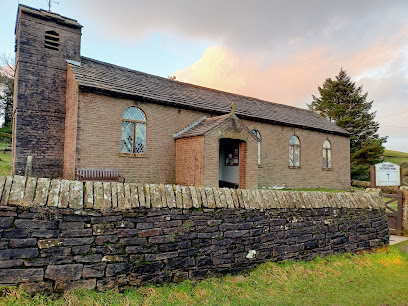
| Description | : | Forest Chapel stands in an isolated position in the civil parish of Macclesfield Forest and Wildboarclough in Cheshire, England, within the Peak District National Park 4.5 miles (7 km) from Macclesfield. It is recorded in the National Heritage List for England as a designated Grade II listed building.[1] It is an Anglican church in the diocese of Chester, the archdeaconry of Macclesfield and the deanery of Macclesfield. Its benefice is combined with those of Jenkin Chapel, Saltersford and Holy Trinity, Rainow.[2] https://en.wikipedia.org/wiki/Forest_Chapel https://www.britainexpress.com/attractions.htm?attraction=5008 |
frequently asked questions (FAQ):
-
Where is St . Stephen's Church Forest Chapel?
St . Stephen's Church Forest Chapel is located at Macclesfield Forest, Cheshire East Unitary Authority ,Cheshire ,England.
-
St . Stephen's Church Forest Chapel cemetery's updated grave count on graveviews.com?
0 memorials
-
Where are the coordinates of the St . Stephen's Church Forest Chapel?
Latitude: 53.2462260
Longitude: -2.0399720
Nearby Cemetories:
1. St. Saviour Churchyard
Wildboarclough, Cheshire East Unitary Authority, England
Coordinate: 53.2161170, -2.0254580
2. St James Churchyard
Sutton (Macclesfield), Cheshire East Unitary Authority, England
Coordinate: 53.2378520, -2.1063910
3. St. John the Evangelist Churchyard
Cheshire East Unitary Authority, England
Coordinate: 53.2862960, -2.0256440
4. Wesleyan Chapel Chapelyard
Rainow, Cheshire East Unitary Authority, England
Coordinate: 53.2835470, -2.0709590
5. Holy Trinity Churchyard
Hurdsfield, Cheshire East Unitary Authority, England
Coordinate: 53.2647300, -2.1124600
6. St Paul Churchyard
Macclesfield, Cheshire East Unitary Authority, England
Coordinate: 53.2574100, -2.1192400
7. St. Michael's & All Angels Churchyard
Macclesfield, Cheshire East Unitary Authority, England
Coordinate: 53.2572950, -2.1195970
8. Brunswick Wesleyan Methodist Chapel Chapelyard
Sutton (Macclesfield), Cheshire East Unitary Authority, England
Coordinate: 53.2359570, -2.1213260
9. St. Michael's Churchyard
Wincle, Cheshire East Unitary Authority, England
Coordinate: 53.1933190, -2.0620740
10. St. Alban's Churchyard
Macclesfield, Cheshire East Unitary Authority, England
Coordinate: 53.2599190, -2.1339940
11. St John the Baptist Churchyard
Bollington, Cheshire East Unitary Authority, England
Coordinate: 53.2969600, -2.0926100
12. Macclesfield Crematorium
Macclesfield, Cheshire East Unitary Authority, England
Coordinate: 53.2656340, -2.1373290
13. Macclesfield Cemetery
Macclesfield, Cheshire East Unitary Authority, England
Coordinate: 53.2652260, -2.1376130
14. Christ Church Churchyard
Burbage, High Peak Borough, England
Coordinate: 53.2528840, -1.9357390
15. St. Paul's Churchyard
Quarnford, Staffordshire Moorlands District, England
Coordinate: 53.2018260, -1.9628630
16. St. Christopher Churchyard
Pott Shrigley, Cheshire East Unitary Authority, England
Coordinate: 53.3096500, -2.0842900
17. Fernilee Methodist Church
Fernilee, High Peak Borough, England
Coordinate: 53.3072690, -1.9752940
18. St John the Baptist Churchyard
Buxton, High Peak Borough, England
Coordinate: 53.2589380, -1.9172770
19. Church of St. Anne
Buxton, High Peak Borough, England
Coordinate: 53.2538256, -1.9157350
20. St. James Churchyard
Whaley Bridge, High Peak Borough, England
Coordinate: 53.3153270, -1.9918840
21. St. Mary the Virgin Churchyard
Bosley, Cheshire East Unitary Authority, England
Coordinate: 53.1871110, -2.1241630
22. Maggoty Wood
Gawsworth, Cheshire East Unitary Authority, England
Coordinate: 53.2234560, -2.1652510
23. St James Churchyard
Gawsworth, Cheshire East Unitary Authority, England
Coordinate: 53.2241390, -2.1661520
24. St Peter Churchyard
Prestbury, Cheshire East Unitary Authority, England
Coordinate: 53.2892070, -2.1505100