

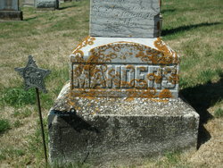
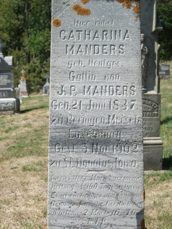
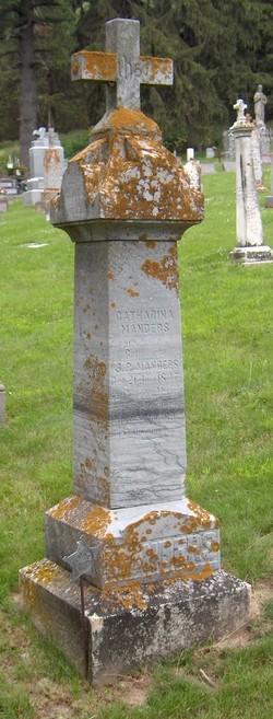
Catharina Hentges Manders
| Birth | : | 21 Jun 1837 Beringen, Canton de Mersch, Luxembourg, Luxembourg |
| Death | : | 5 Nov 1902 Saint Donatus, Jackson County, Iowa, USA |
| Burial | : | St Sebastian Churchyard, Great Gonerby, South Kesteven District, England |
| Coordinate | : | 52.9329260, -0.6657700 |
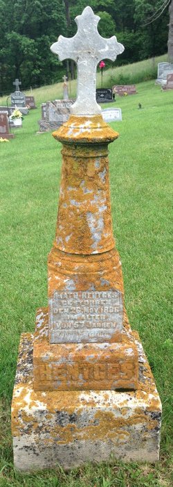
| Inscription | : | This headstone had the following – one person on each side: Manders, J.P., geb October 10, 1828 in Sandweiler, Luxembourg, died May 6, 1910 in St. Donatus, Iowa. (translation – Manders, J.P. (Johann Peter), born October 10, |
frequently asked questions (FAQ):
-
Where is Catharina Hentges Manders's memorial?
Catharina Hentges Manders's memorial is located at: St Sebastian Churchyard, Great Gonerby, South Kesteven District, England.
-
When did Catharina Hentges Manders death?
Catharina Hentges Manders death on 5 Nov 1902 in Saint Donatus, Jackson County, Iowa, USA
-
Where are the coordinates of the Catharina Hentges Manders's memorial?
Latitude: 52.9329260
Longitude: -0.6657700
Family Members:
Parent

Spouse
Siblings
Children
Flowers:


Nearby Cemetories:
1. St Sebastian Churchyard
Great Gonerby, South Kesteven District, England
Coordinate: 52.9329260, -0.6657700
2. St John the Evangelist Churchyard
Manthorpe, South Kesteven District, England
Coordinate: 52.9306320, -0.6323160
3. Manthorpe Road Old Cemetery
Grantham, South Kesteven District, England
Coordinate: 52.9173900, -0.6409900
4. All Saints Churchyard
Barrowby, South Kesteven District, England
Coordinate: 52.9186420, -0.6946810
5. St. Wulfram Churchyard
Grantham, South Kesteven District, England
Coordinate: 52.9148180, -0.6408520
6. Grantham Cemetery and Crematorium
Grantham, South Kesteven District, England
Coordinate: 52.9095320, -0.6326120
7. St. Peter and St. Paul's Churchyard
Belton, South Kesteven District, England
Coordinate: 52.9451000, -0.6177000
8. St. Lawrence Churchyard
Sedgebrook, South Kesteven District, England
Coordinate: 52.9329460, -0.7256530
9. St Marys Churchyard
Syston, South Kesteven District, England
Coordinate: 52.9578420, -0.6172940
10. St James Churchyard
Allington, South Kesteven District, England
Coordinate: 52.9525695, -0.7245301
11. St Nicholas Churchyard
Barkston, South Kesteven District, England
Coordinate: 52.9629960, -0.6129380
12. St John the Baptist Churchyard
Londonthorpe, South Kesteven District, England
Coordinate: 52.9312060, -0.5837350
13. St Mary and St Peter Churchyard
Harlaxton, South Kesteven District, England
Coordinate: 52.8836860, -0.6895640
14. All Saints Churchyard
Hougham, South Kesteven District, England
Coordinate: 52.9878240, -0.6806910
15. St Peter Churchyard
Foston, South Kesteven District, England
Coordinate: 52.9771630, -0.7227360
16. St. Guthlac Churchyard
Little Ponton, South Kesteven District, England
Coordinate: 52.8796100, -0.6271200
17. St Andrew Churchyard
Denton, South Kesteven District, England
Coordinate: 52.8828830, -0.7151840
18. St John the Baptist Churchyard
Muston, Melton Borough, England
Coordinate: 52.9315700, -0.7680600
19. St. Wilfrid Churchyard
Honington, South Kesteven District, England
Coordinate: 52.9795600, -0.5965700
20. All Saints Churchyard
Stroxton, South Kesteven District, England
Coordinate: 52.8695300, -0.6609700
21. St James Churchyard
Woolsthorpe-by-Belvoir, South Kesteven District, England
Coordinate: 52.8957880, -0.7578370
22. All Saints Churchyard
Westborough, South Kesteven District, England
Coordinate: 52.9892900, -0.7350100
23. St. Mary Magdalene Churchyard
Old Somerby, South Kesteven District, England
Coordinate: 52.8944900, -0.5672830
24. St Swithun Churchyard
Long Bennington, South Kesteven District, England
Coordinate: 52.9856290, -0.7449190