
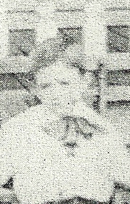
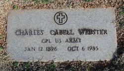
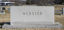

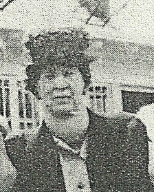
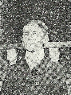
Charles Cabell Webster
| Birth | : | 10 Jan 1896 Madison, Rockingham County, North Carolina, USA |
| Death | : | 6 Oct 1985 Greensboro, Guilford County, North Carolina, USA |
| Burial | : | St Mary and St Nicholas Churchyard, Leatherhead, Mole Valley District, England |
| Coordinate | : | 51.2925810, -0.3269850 |
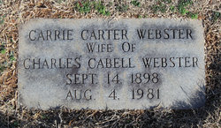
| Description | : | He was called "Cabell." On 19 Sept 1927 he married Carrie Bell Carter. She was born 14 Sept 1898 and died 4 Aug. 1981. === Carrie was a clerk and buyer at Busicks Department Store which was owned by Cabell Webster and Wade Gentry. === Cabell was a clothing merchant and was for 55 years the treasurer of Madison Methodist Church. He was president of the Board of Directors of the Madison Savings and Loan. He was town commissioner when the first water system was installed in Madison, N.C. === Cabell was widowed and lived at 208 W. Hunter Street in Madison, N.C. when he died at age 89. |
frequently asked questions (FAQ):
-
Where is Charles Cabell Webster's memorial?
Charles Cabell Webster's memorial is located at: St Mary and St Nicholas Churchyard, Leatherhead, Mole Valley District, England.
-
When did Charles Cabell Webster death?
Charles Cabell Webster death on 6 Oct 1985 in Greensboro, Guilford County, North Carolina, USA
-
Where are the coordinates of the Charles Cabell Webster's memorial?
Latitude: 51.2925810
Longitude: -0.3269850
Family Members:
Parent
Spouse
Siblings

Flowers:


Nearby Cemetories:
1. St Mary and St Nicholas Churchyard
Leatherhead, Mole Valley District, England
Coordinate: 51.2925810, -0.3269850
2. St Mary Churchyard
Fetcham, Mole Valley District, England
Coordinate: 51.2881290, -0.3525500
3. Randalls Park Cemetery and Crematorium
Leatherhead, Mole Valley District, England
Coordinate: 51.3035290, -0.3469730
4. St Michael Churchyard
Mickleham, Mole Valley District, England
Coordinate: 51.2675150, -0.3233720
5. St Giles Churchyard
Ashtead, Mole Valley District, England
Coordinate: 51.3086540, -0.2900093
6. St Nicolas Parish Churchyard
Great Bookham, Mole Valley District, England
Coordinate: 51.2798220, -0.3739870
7. Yehudi Menuhin International School
Stoke D'Abernon, Elmbridge Borough, England
Coordinate: 51.3059170, -0.3775720
8. St Marys Churchyard
Headley, Mole Valley District, England
Coordinate: 51.2799700, -0.2736100
9. All Saints Churchyard
Little Bookham, Mole Valley District, England
Coordinate: 51.2826900, -0.3864790
10. St Marys Churchyard
Stoke D'Abernon, Elmbridge Borough, England
Coordinate: 51.3139230, -0.3812710
11. Polesden Lacey Estate Pet Cemetery
Great Bookham, Mole Valley District, England
Coordinate: 51.2592260, -0.3718640
12. Polesden Lacey Estate
Great Bookham, Mole Valley District, England
Coordinate: 51.2591310, -0.3718630
13. St Lawrence Churchyard
Effingham, Guildford Borough, England
Coordinate: 51.2712010, -0.3984180
14. Epsom Cemetery
Epsom, Epsom and Ewell Borough, England
Coordinate: 51.3198040, -0.2594180
15. Cobham Municipal Cemetery
Cobham, Elmbridge Borough, England
Coordinate: 51.3204240, -0.3954060
16. Saint Peter's Church
Walton-on-the-Hill, Reigate and Banstead Borough, England
Coordinate: 51.2817810, -0.2467230
17. St. Barnabas Churchyard
Ranmore Common, Mole Valley District, England
Coordinate: 51.2419730, -0.3602730
18. Dorking Cemetery
Dorking, Mole Valley District, England
Coordinate: 51.2365646, -0.3189580
19. St. Martin of Tours Churchyard
Epsom, Epsom and Ewell Borough, England
Coordinate: 51.3306847, -0.2593640
20. St Martin Churchyard
Dorking, Mole Valley District, England
Coordinate: 51.2326360, -0.3320140
21. Deepdene Mausoleum
Dorking, Mole Valley District, England
Coordinate: 51.2307590, -0.3206630
22. St Andrew Churchyard
Cobham, Elmbridge Borough, England
Coordinate: 51.3259580, -0.4114970
23. Holy Trinity Churchyard
Claygate, Elmbridge Borough, England
Coordinate: 51.3588960, -0.3394210
24. St Mary the Virgin Churchyard
Chessington, Royal Borough of Kingston upon Thames, England
Coordinate: 51.3580840, -0.3001320