
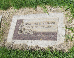
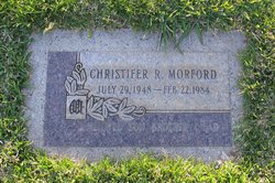

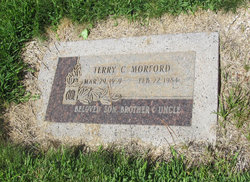
Christifer Roy Morford
| Birth | : | 29 Jul 1948 Michigan, USA |
| Death | : | 22 Feb 1984 Contra Costa County, California, USA |
| Burial | : | New Auburn Cemetery, Auburn, Placer County, USA |
| Coordinate | : | 38.9026900, -121.0870800 |
| Plot | : | N/C-9-31-1 |
frequently asked questions (FAQ):
-
Where is Christifer Roy Morford's memorial?
Christifer Roy Morford's memorial is located at: New Auburn Cemetery, Auburn, Placer County, USA.
-
When did Christifer Roy Morford death?
Christifer Roy Morford death on 22 Feb 1984 in Contra Costa County, California, USA
-
Where are the coordinates of the Christifer Roy Morford's memorial?
Latitude: 38.9026900
Longitude: -121.0870800
Family Members:
Parent
Siblings


Nearby Cemetories:
1. New Auburn Cemetery
Auburn, Placer County, USA
Coordinate: 38.9026900, -121.0870800
2. Old Auburn Cemetery
Auburn, Placer County, USA
Coordinate: 38.9023720, -121.0812230
3. Clark Ashton Smith Gravesite
Auburn, Placer County, USA
Coordinate: 38.8952100, -121.0770500
4. Placer County Hospital Cemetery
Auburn, Placer County, USA
Coordinate: 38.9045120, -121.0721320
5. Bethlehem Lutheran Church Columbarium
Auburn, Placer County, USA
Coordinate: 38.8932350, -121.0749690
6. First Congregational Church Memorial Garden
Auburn, Placer County, USA
Coordinate: 38.9118660, -121.0711770
7. Chinese Cemetery
Auburn, Placer County, USA
Coordinate: 38.9183502, -121.0802383
8. Maidu Indian Burial Grounds
Auburn, Placer County, USA
Coordinate: 38.8744350, -121.0777290
9. Ophir Cemetery
Placer County, USA
Coordinate: 38.8928870, -121.1273790
10. Newcastle Cemetery
Newcastle, Placer County, USA
Coordinate: 38.8708880, -121.1444060
11. Wells Cemetery
Auburn, Placer County, USA
Coordinate: 38.9667000, -121.1054900
12. Gold Hill Cemetery
Gold Hill, Placer County, USA
Coordinate: 38.9025000, -121.1802200
13. Stewarts Flat Cemetery
Penryn, Placer County, USA
Coordinate: 38.8447360, -121.1507950
14. Bayley Family Cemetery
Pilot Hill, El Dorado County, USA
Coordinate: 38.8438800, -121.0148900
15. Lone Star Cemetery
Placer County, USA
Coordinate: 38.9757996, -121.1380997
16. Rattlesnake Bar Graveyard
Auburn, Placer County, USA
Coordinate: 38.8163050, -121.0895100
17. Clipper Gap Cemetery
Clipper Gap, Placer County, USA
Coordinate: 38.9784880, -121.0256590
18. Mansur Family Cemetery
Loomis, Placer County, USA
Coordinate: 38.8139600, -121.1214000
19. Pilot Hill Cemetery
Pilot Hill, El Dorado County, USA
Coordinate: 38.8301010, -121.0093307
20. Prosser Family Cemetery
Loomis, Placer County, USA
Coordinate: 38.8071900, -121.1285600
21. Esoteric Fraternity Cemetery
Applegate, Placer County, USA
Coordinate: 38.9946190, -120.9687490
22. Georgetown-Renke Cemetery Annex
Georgetown, El Dorado County, USA
Coordinate: 38.8964610, -120.9116240
23. Greenwood Pioneer Cemetery
Greenwood, El Dorado County, USA
Coordinate: 38.8985786, -120.9099274
24. Spanish Dry Diggings Cemetery
Greenwood, El Dorado County, USA
Coordinate: 38.9431600, -120.9158000