
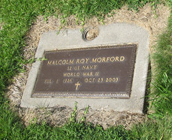

Malcolm Roy Morford
| Birth | : | 1 Jul 1926 Crystal Falls, Iron County, Michigan, USA |
| Death | : | 17 Oct 2003 |
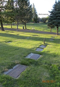
| Burial | : | New Auburn Cemetery, Auburn, Placer County, USA |
| Coordinate | : | 38.9026900, -121.0870800 |
| Plot | : | N/C-9-31-4 |
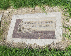
| Description | : | Malcolm M. Morford 7/1/1926-10/17/2003 WORLD WAR II VETERAN A loving and caring man passed away Friday morning, October 17, 2003. Mal was born Malcolm Roy Morford to Malcolm Marian & Marie Morford on July 1, 1926 in Crystal Falls, Michigan. He joined the U.S. Navy in 1943 and became a "Sea Bee". He was stationed in the South Pacific until he was discharged in 1945. He married Janie Turpin on September 6, 1947. Three boys were born to this union, Christofer Roy, Ric Malcolm, Terry Cliff. He had many occupations over his lifetime. He went from being a radio... Read More |
frequently asked questions (FAQ):
-
Where is Malcolm Roy Morford's memorial?
Malcolm Roy Morford's memorial is located at: New Auburn Cemetery, Auburn, Placer County, USA.
-
When did Malcolm Roy Morford death?
Malcolm Roy Morford death on 17 Oct 2003 in
-
Where are the coordinates of the Malcolm Roy Morford's memorial?
Latitude: 38.9026900
Longitude: -121.0870800
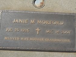
Family Members:
Parent
Spouse
Children


Nearby Cemetories:
1. New Auburn Cemetery
Auburn, Placer County, USA
Coordinate: 38.9026900, -121.0870800
2. Old Auburn Cemetery
Auburn, Placer County, USA
Coordinate: 38.9023720, -121.0812230
3. Clark Ashton Smith Gravesite
Auburn, Placer County, USA
Coordinate: 38.8952100, -121.0770500
4. Placer County Hospital Cemetery
Auburn, Placer County, USA
Coordinate: 38.9045120, -121.0721320
5. Bethlehem Lutheran Church Columbarium
Auburn, Placer County, USA
Coordinate: 38.8932350, -121.0749690
6. First Congregational Church Memorial Garden
Auburn, Placer County, USA
Coordinate: 38.9118660, -121.0711770
7. Chinese Cemetery
Auburn, Placer County, USA
Coordinate: 38.9183502, -121.0802383
8. Maidu Indian Burial Grounds
Auburn, Placer County, USA
Coordinate: 38.8744350, -121.0777290
9. Ophir Cemetery
Placer County, USA
Coordinate: 38.8928870, -121.1273790
10. Newcastle Cemetery
Newcastle, Placer County, USA
Coordinate: 38.8708880, -121.1444060
11. Wells Cemetery
Auburn, Placer County, USA
Coordinate: 38.9667000, -121.1054900
12. Gold Hill Cemetery
Gold Hill, Placer County, USA
Coordinate: 38.9025000, -121.1802200
13. Stewarts Flat Cemetery
Penryn, Placer County, USA
Coordinate: 38.8447360, -121.1507950
14. Bayley Family Cemetery
Pilot Hill, El Dorado County, USA
Coordinate: 38.8438800, -121.0148900
15. Lone Star Cemetery
Placer County, USA
Coordinate: 38.9757996, -121.1380997
16. Rattlesnake Bar Graveyard
Auburn, Placer County, USA
Coordinate: 38.8163050, -121.0895100
17. Clipper Gap Cemetery
Clipper Gap, Placer County, USA
Coordinate: 38.9784880, -121.0256590
18. Mansur Family Cemetery
Loomis, Placer County, USA
Coordinate: 38.8139600, -121.1214000
19. Pilot Hill Cemetery
Pilot Hill, El Dorado County, USA
Coordinate: 38.8301010, -121.0093307
20. Prosser Family Cemetery
Loomis, Placer County, USA
Coordinate: 38.8071900, -121.1285600
21. Esoteric Fraternity Cemetery
Applegate, Placer County, USA
Coordinate: 38.9946190, -120.9687490
22. Georgetown-Renke Cemetery Annex
Georgetown, El Dorado County, USA
Coordinate: 38.8964610, -120.9116240
23. Greenwood Pioneer Cemetery
Greenwood, El Dorado County, USA
Coordinate: 38.8985786, -120.9099274
24. Spanish Dry Diggings Cemetery
Greenwood, El Dorado County, USA
Coordinate: 38.9431600, -120.9158000