
| Birth | : | 1 May 1887 Turner County, South Dakota, USA |
| Death | : | 22 Dec 1930 Sioux City, Woodbury County, Iowa, USA |
| Burial | : | Goudhurst Cemetery, Goudhurst, Tunbridge Wells Borough, England |
| Coordinate | : | 51.1134210, 0.4624930 |
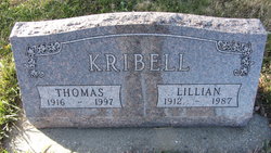
| Inscription | : | "Father" |
frequently asked questions (FAQ):
-
Where is Christopher M. “Chris” Lawrenson's memorial?
Christopher M. “Chris” Lawrenson's memorial is located at: Goudhurst Cemetery, Goudhurst, Tunbridge Wells Borough, England.
-
When did Christopher M. “Chris” Lawrenson death?
Christopher M. “Chris” Lawrenson death on 22 Dec 1930 in Sioux City, Woodbury County, Iowa, USA
-
Where are the coordinates of the Christopher M. “Chris” Lawrenson's memorial?
Latitude: 51.1134210
Longitude: 0.4624930
Family Members:
Parent


Spouse

Siblings
Children
Flowers:


Nearby Cemetories:
1. Goudhurst Cemetery
Goudhurst, Tunbridge Wells Borough, England
Coordinate: 51.1134210, 0.4624930
2. St. Mary the Virgin Churchyard
Goudhurst, Tunbridge Wells Borough, England
Coordinate: 51.1136160, 0.4609480
3. Goudhurst War Memorial
Goudhurst, Tunbridge Wells Borough, England
Coordinate: 51.1129960, 0.4586850
4. St Margarets Churchyard
Horsmonden, Tunbridge Wells Borough, England
Coordinate: 51.1169060, 0.4329730
5. Christ Church Churchyard
Kilndown, Tunbridge Wells Borough, England
Coordinate: 51.0907820, 0.4269340
6. St Mary the Virgin Churchyard
Lamberhurst, Tunbridge Wells Borough, England
Coordinate: 51.1040459, 0.4012690
7. St Dunstan's Churchyard
Cranbrook, Tunbridge Wells Borough, England
Coordinate: 51.0973030, 0.5363690
8. St David's Bridge Strict Baptist Chapel
Cranbrook, Tunbridge Wells Borough, England
Coordinate: 51.0953430, 0.5378980
9. All Saints Churchyard
Brenchley, Tunbridge Wells Borough, England
Coordinate: 51.1504200, 0.4001200
10. Cranbrook Cemetery
Cranbrook, Tunbridge Wells Borough, England
Coordinate: 51.0962250, 0.5541360
11. Saint Augustine's Churchyard
Flimwell, Rother District, England
Coordinate: 51.0514170, 0.4580350
12. Sissinghurst Cemetery
Sissinghurst, Tunbridge Wells Borough, England
Coordinate: 51.1095310, 0.5629240
13. Marden Congregational Church
Marden, Maidstone Borough, England
Coordinate: 51.1745670, 0.4897280
14. St. Michael and All Angels Churchyard
Marden, Maidstone Borough, England
Coordinate: 51.1743202, 0.4931720
15. Bayham Old Abbey
Lamberhurst, Tunbridge Wells Borough, England
Coordinate: 51.1032690, 0.3541800
16. St. Luke's Churchyard
Matfield, Tunbridge Wells Borough, England
Coordinate: 51.1426588, 0.3626785
17. All Saints Church
Staplehurst, Maidstone Borough, England
Coordinate: 51.1582160, 0.5527170
18. St. Margaret's Churchyard
Collier Street, Maidstone Borough, England
Coordinate: 51.1877010, 0.4555280
19. Paddock Wood New Cemetery
Paddock Wood, Tunbridge Wells Borough, England
Coordinate: 51.1761499, 0.3980419
20. St. Mary's Churchyard
Ticehurst, Rother District, England
Coordinate: 51.0454030, 0.4077110
21. Marian Martyrs Memorial
Staplehurst, Maidstone Borough, England
Coordinate: 51.1649780, 0.5523900
22. Marden Cemetery
Marden, Maidstone Borough, England
Coordinate: 51.1882744, 0.4894070
23. St. Andrew's Old Churchyard
Paddock Wood, Tunbridge Wells Borough, England
Coordinate: 51.1799720, 0.3923060
24. St. Laurence Churchyard
Hawkhurst, Tunbridge Wells Borough, England
Coordinate: 51.0377240, 0.5031610