


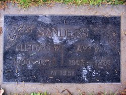
Clifford William Sanders
| Birth | : | 6 Nov 1900 Broughton, Clay County, Kansas, USA |
| Death | : | 19 Aug 1977 Napa, Napa County, California, USA |
| Burial | : | Pilot Grove City Cemetery, Pilot Grove, Cooper County, USA |
| Coordinate | : | 38.8788930, -92.9131360 |
| Description | : | Clifford Sanders, a former member of the Napa City Planning Commission, died Friday [August 19, 1977] at Queen of the Valley Hospital. He was 76. A resident of Napa for 35 years, Sanders was active in community affairs, serving as president of the Lion's Club, past member of the Elks Club and as a marshal for the Kaiser International Golf Tournament. He was born [November 6, 1900] in Broughton, Kansas, and graduated from Manual Training High School in Kansas City, Mo. He attended the University of Missouri at Columbia where he was active in football, baseball, and track. He was... Read More |
frequently asked questions (FAQ):
-
Where is Clifford William Sanders's memorial?
Clifford William Sanders's memorial is located at: Pilot Grove City Cemetery, Pilot Grove, Cooper County, USA.
-
When did Clifford William Sanders death?
Clifford William Sanders death on 19 Aug 1977 in Napa, Napa County, California, USA
-
Where are the coordinates of the Clifford William Sanders's memorial?
Latitude: 38.8788930
Longitude: -92.9131360
Family Members:
Parent

Spouse
Siblings
Flowers:


Nearby Cemetories:
1. Pilot Grove City Cemetery
Pilot Grove, Cooper County, USA
Coordinate: 38.8788930, -92.9131360
2. Garibaldi Mausoleum
Carano, Provincia di Latina, Italy
Coordinate: 38.8747215, -92.9113922
3. Saint Joseph's Catholic Cemetery
Pilot Grove, Cooper County, USA
Coordinate: 38.8636017, -92.9088974
4. Wesley Chapel Cemetery
Pilot Grove, Cooper County, USA
Coordinate: 38.8626750, -92.9235120
5. Mount Vernon Cemetery
Pilot Grove, Cooper County, USA
Coordinate: 38.8586006, -92.9150009
6. Saint Martins Cemetery
Pilot Grove, Cooper County, USA
Coordinate: 38.9169006, -92.8778000
7. Saint Paul Cemetery New
Pilot Grove, Cooper County, USA
Coordinate: 38.8642350, -92.9722930
8. Saint Paul Cemetery Old
Pilot Grove, Cooper County, USA
Coordinate: 38.8631010, -92.9718320
9. Saint John's Cemetery
Clear Creek, Cooper County, USA
Coordinate: 38.8600660, -92.9772640
10. Pleasant Hill Cemetery
Cooper County, USA
Coordinate: 38.8955994, -92.8383026
11. Schuster Family Cemetery
Lamine, Cooper County, USA
Coordinate: 38.9526600, -92.8862720
12. Mount Nebo Baptist Church and Cemetery
Pilot Grove, Cooper County, USA
Coordinate: 38.8034970, -92.8896760
13. Prairie Lick Cemetery
Billingsville, Cooper County, USA
Coordinate: 38.9170410, -92.8257630
14. Old Mount Nebo Cemetery
Bunceton, Cooper County, USA
Coordinate: 38.7999520, -92.8797250
15. Bethel Memorial Gardens
Speed, Cooper County, USA
Coordinate: 38.8538100, -92.8111400
16. Allison Family Cemetery
Blackwater, Cooper County, USA
Coordinate: 38.9447910, -92.9801270
17. Herndon Cemetery
Cooper County, USA
Coordinate: 38.9592018, -92.8767014
18. Jones Chapel Cemetery
Cooper County, USA
Coordinate: 38.9433060, -92.8348710
19. Briscoe Cemetery
Cooper County, USA
Coordinate: 38.8025017, -92.8535995
20. Old Lamine Cemetery
Lamine, Cooper County, USA
Coordinate: 38.9683330, -92.9275000
21. Peninsula Cemetery
Lamine, Cooper County, USA
Coordinate: 38.9482840, -92.9915830
22. Saint Johns UCC Cemetery
Billingsville, Cooper County, USA
Coordinate: 38.9042410, -92.7951050
23. Pleasant Green Cemetery
Pleasant Green, Cooper County, USA
Coordinate: 38.8016950, -92.9903690
24. Pleasant Green Methodist Church Old Cemetery
Cooper County, USA
Coordinate: 38.8013480, -92.9911630