
| Birth | : | 5 Jul 1927 Clay Center, Clay County, Kansas, USA |
| Death | : | 27 Aug 2010 Topeka, Shawnee County, Kansas, USA |
| Burial | : | Old Mayfield Cemetery, Eaton, Gibson County, USA |
| Coordinate | : | 35.9894960, -89.1666780 |
| Plot | : | McInerney, Lot 460-C |
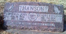
| Description | : | Doris Evelyn Centlivre, 83, of Topeka, died August 27, 2010, after a long battle with Parkinsons Disease. She was born on July 5, 1927, the daughter of Warren and Gladys (Larsen) Hanson in Clay Center, Kansas. She was a long time member of Holy Name Catholic Church, American Legion Auxiliary and was an avid bowler. She also enjoyed dancing, playing pool and fishing. Doris worked for Santa Fe Railroad for 28 years before retiring. Doris married David J. Centlivre on February 18, 1950, at Holy Name Catholic Church in Topeka. He preceded her in death on March 28, 1978 She... Read More |
frequently asked questions (FAQ):
-
Where is Doris Evelyn Hanson Centlivre's memorial?
Doris Evelyn Hanson Centlivre's memorial is located at: Old Mayfield Cemetery, Eaton, Gibson County, USA.
-
When did Doris Evelyn Hanson Centlivre death?
Doris Evelyn Hanson Centlivre death on 27 Aug 2010 in Topeka, Shawnee County, Kansas, USA
-
Where are the coordinates of the Doris Evelyn Hanson Centlivre's memorial?
Latitude: 35.9894960
Longitude: -89.1666780
Family Members:
Parent

Spouse

Siblings
Children
Flowers:


Nearby Cemetories:
1. Old Mayfield Cemetery
Eaton, Gibson County, USA
Coordinate: 35.9894960, -89.1666780
2. Mayfield Cemetery
Eaton, Gibson County, USA
Coordinate: 35.9910230, -89.1678300
3. Young & Williams Cemetery
Elizabeth, Crockett County, USA
Coordinate: 35.9707990, -89.1937240
4. Elizabeth Methodist Church Cemetery
Elizabeth, Crockett County, USA
Coordinate: 35.9605010, -89.1770140
5. Spring Hill Baptist Church Cemetery
Eaton, Gibson County, USA
Coordinate: 35.9859520, -89.1221080
6. Springhill MB Church Cemetery
Eaton, Gibson County, USA
Coordinate: 35.9871860, -89.1210420
7. Bethesda Cemetery
Wilcox, Crockett County, USA
Coordinate: 35.9361230, -89.1557970
8. Shaw Cemetery
Tatumville, Dyer County, USA
Coordinate: 36.0435982, -89.1868973
9. Hendrix Cemetery
Tigrett, Dyer County, USA
Coordinate: 35.9511500, -89.2206950
10. Allen Chapel Cemetery
Tigrett, Dyer County, USA
Coordinate: 35.9511400, -89.2207500
11. Wilson Cemetery
Gibson County, USA
Coordinate: 35.9706001, -89.0980988
12. Mays Chapel Cemetery
Friendship, Crockett County, USA
Coordinate: 35.9363540, -89.2006050
13. Deaton Cemetery
Friendship, Crockett County, USA
Coordinate: 35.9350080, -89.2122640
14. Williams Chapel Baptist Church Cemetery
Friendship, Crockett County, USA
Coordinate: 35.9258940, -89.1916320
15. Edwards Cemetery
Friendship, Crockett County, USA
Coordinate: 35.9314120, -89.2146810
16. Concidine Gravesite
Gibson County, USA
Coordinate: 35.9930000, -89.0800000
17. McGary Family Cemetery
Tigrett, Dyer County, USA
Coordinate: 35.9649530, -89.2501520
18. Walnut Grove Cemetery
Trenton, Gibson County, USA
Coordinate: 35.9947014, -89.0764008
19. Saint Peter Cemetery
Tigrett, Dyer County, USA
Coordinate: 35.9616440, -89.2520140
20. Roberts Family Cemetery
Eaton, Gibson County, USA
Coordinate: 35.9882200, -89.0734100
21. Rogers Cemetery
RoEllen, Dyer County, USA
Coordinate: 36.0069000, -89.2618000
22. Sanders Cemetery
Crockett Mills, Crockett County, USA
Coordinate: 35.9096750, -89.1609030
23. Salem Primitive Baptist Cemetery
Hickory Grove, Gibson County, USA
Coordinate: 35.9681400, -89.0709700
24. Bowen Chapel Cemetery
Friendship, Dyer County, USA
Coordinate: 35.9311810, -89.2353720