
| Birth | : | 21 Jul 1931 Council Bluffs, Pottawattamie County, Iowa, USA |
| Death | : | 24 Jun 2011 Council Bluffs, Pottawattamie County, Iowa, USA |
| Burial | : | Garner Cemetery, Council Bluffs, Pottawattamie County, USA |
| Coordinate | : | 41.2956161, -95.8001709 |
| Plot | : | Blk 15, Lot 23, Space 6 |
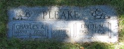
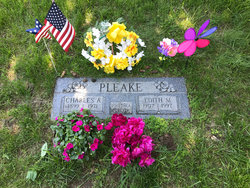
| Description | : | Dorothy A. Stark, age 79, of Council Bluffs, Iowa, passed away June 24, 2011 at Risen Son Christian Village. Dorothy was born July 21, 1931, in Council Bluffs to the late Charles E. and Edith M. (Rickabaugh) Pleake. She graduated from Thomas Jefferson High School in 1948. Dorothy was a homemaker and was the activities director for Elder Care at Mercy Hospital. She was preceded in death by her husband, Donald Jack Stark, in 1998; brother, Charles Pleake; sisters, Shirley Clark and Gerry O'Bradovich. Dorothy is survived by daughters, Debra (Rick) Ogle, DeAnne (Chris) Nadler, all of Council Bluffs, Denise (Tim) Blackerby, of... Read More |
frequently asked questions (FAQ):
-
Where is Dorothy Arlene Pleake Stark's memorial?
Dorothy Arlene Pleake Stark's memorial is located at: Garner Cemetery, Council Bluffs, Pottawattamie County, USA.
-
When did Dorothy Arlene Pleake Stark death?
Dorothy Arlene Pleake Stark death on 24 Jun 2011 in Council Bluffs, Pottawattamie County, Iowa, USA
-
Where are the coordinates of the Dorothy Arlene Pleake Stark's memorial?
Latitude: 41.2956161
Longitude: -95.8001709
Family Members:
Parent
Spouse

Siblings
Flowers:


Nearby Cemetories:
1. Garner Cemetery
Council Bluffs, Pottawattamie County, USA
Coordinate: 41.2956161, -95.8001709
2. Green Valley Cemetery
Council Bluffs, Pottawattamie County, USA
Coordinate: 41.2743988, -95.8225021
3. Saint Joseph Cemetery
Council Bluffs, Pottawattamie County, USA
Coordinate: 41.2722015, -95.8208008
4. Cedar Lawn Cemetery
Council Bluffs, Pottawattamie County, USA
Coordinate: 41.2694016, -95.8182983
5. Walnut Hill Cemetery
Council Bluffs, Pottawattamie County, USA
Coordinate: 41.2719002, -95.8255997
6. Bikhor Cholim Cemetery
Council Bluffs, Pottawattamie County, USA
Coordinate: 41.2703670, -95.8229350
7. Oak Hill Cemetery
Council Bluffs, Pottawattamie County, USA
Coordinate: 41.2700900, -95.8226400
8. Ridgewood Cemetery
Council Bluffs, Pottawattamie County, USA
Coordinate: 41.2694016, -95.8272018
9. Memorial Park Cemetery
Council Bluffs, Pottawattamie County, USA
Coordinate: 41.2644005, -95.8261032
10. Gregg Cemetery
Weston, Pottawattamie County, USA
Coordinate: 41.3330000, -95.7931000
11. Evans Cemetery
Crescent, Pottawattamie County, USA
Coordinate: 41.3255997, -95.8368988
12. Clark Cemetery
Pottawattamie County, USA
Coordinate: 41.2551610, -95.8223390
13. Fairview Cemetery
Council Bluffs, Pottawattamie County, USA
Coordinate: 41.2703018, -95.8480988
14. Stoker-Graybill Cemetery
Council Bluffs, Pottawattamie County, USA
Coordinate: 41.2532620, -95.7751770
15. Hazel Dell Cemetery
Council Bluffs, Pottawattamie County, USA
Coordinate: 41.3489723, -95.7939911
16. Saint Columbanus Cemetery
Weston, Pottawattamie County, USA
Coordinate: 41.3429440, -95.7435260
17. Maple Grove Cemetery
Council Bluffs, Pottawattamie County, USA
Coordinate: 41.2265560, -95.8187100
18. Crescent Cemetery
Crescent, Pottawattamie County, USA
Coordinate: 41.3664894, -95.8566208
19. Lewis Township Cemetery
Council Bluffs, Pottawattamie County, USA
Coordinate: 41.2117004, -95.7938995
20. Downsville Cemetery
Pottawattamie County, USA
Coordinate: 41.3502998, -95.7039032
21. Council Point Cemetery
Council Bluffs, Pottawattamie County, USA
Coordinate: 41.2110830, -95.8788610
22. Pottawattamie County Home Cemetery
McClelland, Pottawattamie County, USA
Coordinate: 41.3269400, -95.6691738
23. Trinity Cathedral Columbarium
Omaha, Douglas County, USA
Coordinate: 41.2603900, -95.9393660
24. Hardin Township Cemetery
McClelland, Pottawattamie County, USA
Coordinate: 41.2949982, -95.6513977