
| Birth | : | 4 Dec 1922 Council Bluffs, Pottawattamie County, Iowa, USA |
| Death | : | 13 May 2007 Bellevue, Sarpy County, Nebraska, USA |
| Burial | : | Memorial Park Cemetery, Council Bluffs, Pottawattamie County, USA |
| Coordinate | : | 41.2644005, -95.8261032 |
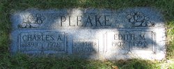
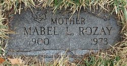
| Description | : | Council Bluffs (Iowa) Nonpareil May 17, 2007 Geraldine J. "Geri" O'Bradovich, age 84, of Council Bluffs, passed away May 13, 2007 at Hillcrest Health and Rehabilitation Center in Bellevue, Neb. Geri was born December 4, 1922 in Council Bluffs to the late Charles and Mabel (Wood) Pleake. She graduated from Thomas Jefferson High School and worked as a sales clerk for Brandeis Dept. Store for 15 years and managed the Payless Shoe Store for 20 years retiring in 1979. Geri was preceded in death by her husband, Joe O'Bradovich, in 2004; and her brother, Charles Pleake... Read More |
frequently asked questions (FAQ):
-
Where is Geraldine Jean Pleake O'Bradovich's memorial?
Geraldine Jean Pleake O'Bradovich's memorial is located at: Memorial Park Cemetery, Council Bluffs, Pottawattamie County, USA.
-
When did Geraldine Jean Pleake O'Bradovich death?
Geraldine Jean Pleake O'Bradovich death on 13 May 2007 in Bellevue, Sarpy County, Nebraska, USA
-
Where are the coordinates of the Geraldine Jean Pleake O'Bradovich's memorial?
Latitude: 41.2644005
Longitude: -95.8261032
Family Members:
Parent
Spouse

Siblings
Children
Flowers:


Nearby Cemetories:
1. Memorial Park Cemetery
Council Bluffs, Pottawattamie County, USA
Coordinate: 41.2644005, -95.8261032
2. Ridgewood Cemetery
Council Bluffs, Pottawattamie County, USA
Coordinate: 41.2694016, -95.8272018
3. Oak Hill Cemetery
Council Bluffs, Pottawattamie County, USA
Coordinate: 41.2700900, -95.8226400
4. Bikhor Cholim Cemetery
Council Bluffs, Pottawattamie County, USA
Coordinate: 41.2703670, -95.8229350
5. Walnut Hill Cemetery
Council Bluffs, Pottawattamie County, USA
Coordinate: 41.2719002, -95.8255997
6. Cedar Lawn Cemetery
Council Bluffs, Pottawattamie County, USA
Coordinate: 41.2694016, -95.8182983
7. Saint Joseph Cemetery
Council Bluffs, Pottawattamie County, USA
Coordinate: 41.2722015, -95.8208008
8. Clark Cemetery
Pottawattamie County, USA
Coordinate: 41.2551610, -95.8223390
9. Green Valley Cemetery
Council Bluffs, Pottawattamie County, USA
Coordinate: 41.2743988, -95.8225021
10. Fairview Cemetery
Council Bluffs, Pottawattamie County, USA
Coordinate: 41.2703018, -95.8480988
11. Garner Cemetery
Council Bluffs, Pottawattamie County, USA
Coordinate: 41.2956161, -95.8001709
12. Maple Grove Cemetery
Council Bluffs, Pottawattamie County, USA
Coordinate: 41.2265560, -95.8187100
13. Stoker-Graybill Cemetery
Council Bluffs, Pottawattamie County, USA
Coordinate: 41.2532620, -95.7751770
14. Lewis Township Cemetery
Council Bluffs, Pottawattamie County, USA
Coordinate: 41.2117004, -95.7938995
15. Evans Cemetery
Crescent, Pottawattamie County, USA
Coordinate: 41.3255997, -95.8368988
16. Council Point Cemetery
Council Bluffs, Pottawattamie County, USA
Coordinate: 41.2110830, -95.8788610
17. Gregg Cemetery
Weston, Pottawattamie County, USA
Coordinate: 41.3330000, -95.7931000
18. Trinity Cathedral Columbarium
Omaha, Douglas County, USA
Coordinate: 41.2603900, -95.9393660
19. Hazel Dell Cemetery
Council Bluffs, Pottawattamie County, USA
Coordinate: 41.3489723, -95.7939911
20. Saint Columbanus Cemetery
Weston, Pottawattamie County, USA
Coordinate: 41.3429440, -95.7435260
21. Prospect Hill Cemetery
Omaha, Douglas County, USA
Coordinate: 41.2780991, -95.9593964
22. Crescent Cemetery
Crescent, Pottawattamie County, USA
Coordinate: 41.3664894, -95.8566208
23. First Central Congregational Columbarium
Omaha, Douglas County, USA
Coordinate: 41.2563456, -95.9658365
24. Saint Pauls Evangelical Country Church Cemetery
Dumfries, Pottawattamie County, USA
Coordinate: 41.1748352, -95.7492371