

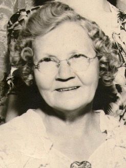
Edith Marie Rickabaugh Pleake
| Birth | : | 28 Jul 1907 Glenwood, Mills County, Iowa, USA |
| Death | : | 28 Dec 1997 Malvern, Mills County, Iowa, USA |
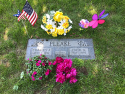
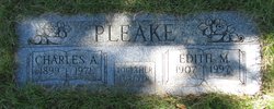
| Burial | : | Cedar Lawn Cemetery, Council Bluffs, Pottawattamie County, USA |
| Coordinate | : | 41.2694016, -95.8182983 |
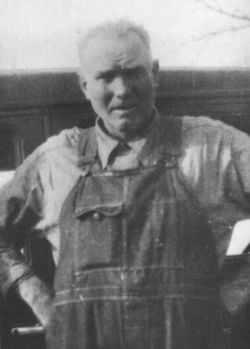
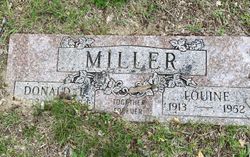
| Description | : | Council Bluffs (Iowa) Nonpareil December 29, 1997. Edith M. Pleake. Edith M. Pleake, 90, of Council Bluffs died Dec. 28 at the Manor of Malvern in Malvern. She was born in Glenwood and was a member of Gethsemane Presbyterian Church. Mrs. Pleake was preceded in death by her husband, Charles, in 1971. Survivors include two daughters, Mrs. Don (Dorothy) Stark and Mrs. Judy Johnson, both of Council Bluffs; two sons, Keith and Kenneth, both of Council Bluffs; a niece whom she raised, Pat Coyle, of Council Bluffs; two stepdaughters, Margaret Oviatt and Gerry O'Bradovich, both of Council Bluffs; a sister, Viola Pedersen,... Read More |
frequently asked questions (FAQ):
-
Where is Edith Marie Rickabaugh Pleake's memorial?
Edith Marie Rickabaugh Pleake's memorial is located at: Cedar Lawn Cemetery, Council Bluffs, Pottawattamie County, USA.
-
When did Edith Marie Rickabaugh Pleake death?
Edith Marie Rickabaugh Pleake death on 28 Dec 1997 in Malvern, Mills County, Iowa, USA
-
Where are the coordinates of the Edith Marie Rickabaugh Pleake's memorial?
Latitude: 41.2694016
Longitude: -95.8182983
Family Members:
Parent
Spouse
Siblings

Children
Flowers:


Nearby Cemetories:
1. Cedar Lawn Cemetery
Council Bluffs, Pottawattamie County, USA
Coordinate: 41.2694016, -95.8182983
2. Oak Hill Cemetery
Council Bluffs, Pottawattamie County, USA
Coordinate: 41.2700900, -95.8226400
3. Saint Joseph Cemetery
Council Bluffs, Pottawattamie County, USA
Coordinate: 41.2722015, -95.8208008
4. Bikhor Cholim Cemetery
Council Bluffs, Pottawattamie County, USA
Coordinate: 41.2703670, -95.8229350
5. Green Valley Cemetery
Council Bluffs, Pottawattamie County, USA
Coordinate: 41.2743988, -95.8225021
6. Walnut Hill Cemetery
Council Bluffs, Pottawattamie County, USA
Coordinate: 41.2719002, -95.8255997
7. Ridgewood Cemetery
Council Bluffs, Pottawattamie County, USA
Coordinate: 41.2694016, -95.8272018
8. Memorial Park Cemetery
Council Bluffs, Pottawattamie County, USA
Coordinate: 41.2644005, -95.8261032
9. Clark Cemetery
Pottawattamie County, USA
Coordinate: 41.2551610, -95.8223390
10. Fairview Cemetery
Council Bluffs, Pottawattamie County, USA
Coordinate: 41.2703018, -95.8480988
11. Garner Cemetery
Council Bluffs, Pottawattamie County, USA
Coordinate: 41.2956161, -95.8001709
12. Stoker-Graybill Cemetery
Council Bluffs, Pottawattamie County, USA
Coordinate: 41.2532620, -95.7751770
13. Maple Grove Cemetery
Council Bluffs, Pottawattamie County, USA
Coordinate: 41.2265560, -95.8187100
14. Evans Cemetery
Crescent, Pottawattamie County, USA
Coordinate: 41.3255997, -95.8368988
15. Lewis Township Cemetery
Council Bluffs, Pottawattamie County, USA
Coordinate: 41.2117004, -95.7938995
16. Gregg Cemetery
Weston, Pottawattamie County, USA
Coordinate: 41.3330000, -95.7931000
17. Council Point Cemetery
Council Bluffs, Pottawattamie County, USA
Coordinate: 41.2110830, -95.8788610
18. Hazel Dell Cemetery
Council Bluffs, Pottawattamie County, USA
Coordinate: 41.3489723, -95.7939911
19. Trinity Cathedral Columbarium
Omaha, Douglas County, USA
Coordinate: 41.2603900, -95.9393660
20. Saint Columbanus Cemetery
Weston, Pottawattamie County, USA
Coordinate: 41.3429440, -95.7435260
21. Crescent Cemetery
Crescent, Pottawattamie County, USA
Coordinate: 41.3664894, -95.8566208
22. Prospect Hill Cemetery
Omaha, Douglas County, USA
Coordinate: 41.2780991, -95.9593964
23. Saint Pauls Evangelical Country Church Cemetery
Dumfries, Pottawattamie County, USA
Coordinate: 41.1748352, -95.7492371
24. First Central Congregational Columbarium
Omaha, Douglas County, USA
Coordinate: 41.2563456, -95.9658365