

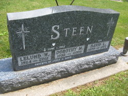
Dorothy Mae Fascher Steen
| Birth | : | 21 Apr 1932 Elkader, Clayton County, Iowa, USA |
| Death | : | 22 Feb 2005 Elkader, Clayton County, Iowa, USA |
| Burial | : | St Peter Churchyard, Ayot St Peter, Welwyn Hatfield District, England |
| Coordinate | : | 51.8201700, -0.2331800 |
frequently asked questions (FAQ):
-
Where is Dorothy Mae Fascher Steen's memorial?
Dorothy Mae Fascher Steen's memorial is located at: St Peter Churchyard, Ayot St Peter, Welwyn Hatfield District, England.
-
When did Dorothy Mae Fascher Steen death?
Dorothy Mae Fascher Steen death on 22 Feb 2005 in Elkader, Clayton County, Iowa, USA
-
Where are the coordinates of the Dorothy Mae Fascher Steen's memorial?
Latitude: 51.8201700
Longitude: -0.2331800
Family Members:
Parent

Spouse
Children

Flowers:


Nearby Cemetories:
1. St Peter Churchyard
Ayot St Peter, Welwyn Hatfield District, England
Coordinate: 51.8201700, -0.2331800
2. Welwyn Cemetery
Welwyn, Welwyn Hatfield District, England
Coordinate: 51.8331340, -0.2199520
3. St. Mary's Churchyard
Welwyn, Welwyn Hatfield District, England
Coordinate: 51.8311660, -0.2151400
4. St John the Evangelist Churchyard
Digswell, Welwyn Hatfield District, England
Coordinate: 51.8186190, -0.2051940
5. St John the Evangelist Churchyard
Lemsford, Welwyn Hatfield District, England
Coordinate: 51.7934510, -0.2355890
6. Ayot St Lawrence Old Churchyard
Ayot St Lawrence, Welwyn Hatfield District, England
Coordinate: 51.8377038, -0.2678795
7. St Lawrence Churchyard
Ayot St Lawrence, Welwyn Hatfield District, England
Coordinate: 51.8379490, -0.2717340
8. St. Helen's Churchyard
Wheathampstead, St Albans District, England
Coordinate: 51.8124510, -0.2946400
9. Wheathampstead United Churchyard
Wheathampstead, St Albans District, England
Coordinate: 51.8108170, -0.2972210
10. Knebworth Cemetery
Knebworth, North Hertfordshire District, England
Coordinate: 51.8595280, -0.1867730
11. Ss Peter and Paul Churchyard
Kimpton, North Hertfordshire District, England
Coordinate: 51.8527990, -0.2918240
12. St. Mary's Churchyard
Knebworth, North Hertfordshire District, England
Coordinate: 51.8723580, -0.2160890
13. St Martin
Knebworth, North Hertfordshire District, England
Coordinate: 51.8654900, -0.1820500
14. St. Luke's Churchyard
Hatfield, Welwyn Hatfield District, England
Coordinate: 51.7643980, -0.2237710
15. All Saints Churchyard
Datchworth, East Hertfordshire District, England
Coordinate: 51.8575577, -0.1609916
16. St Leonard Churchyard & Extension
Sandridge, St Albans District, England
Coordinate: 51.7813690, -0.3036580
17. St. Etheldreda Churchyard
Hatfield, Welwyn Hatfield District, England
Coordinate: 51.7614490, -0.2120150
18. Hatfield Estate
Hatfield, Welwyn Hatfield District, England
Coordinate: 51.7606100, -0.2092010
19. Harwood Park Crematorium
Stevenage, Stevenage Borough, England
Coordinate: 51.8717680, -0.1698410
20. St Andrew Church
Bramfield, East Hertfordshire District, England
Coordinate: 51.8241000, -0.1266000
21. All Saints Churchyard
St Pauls Walden, North Hertfordshire District, England
Coordinate: 51.8865400, -0.2689200
22. St. Mary's Churchyard
Essendon, Welwyn Hatfield District, England
Coordinate: 51.7630460, -0.1561580
23. Westfield Road Cemetery
Harpenden, St Albans District, England
Coordinate: 51.8270720, -0.3540300
24. National Children's Home Cemetery
Harpenden, St Albans District, England
Coordinate: 51.8305000, -0.3563000