
| Birth | : | 20 Jul 1889 Montra, Shelby County, Ohio, USA |
| Death | : | 23 Jan 1959 Omaha, Douglas County, Nebraska, USA |
| Burial | : | Saxilby Cemetery, Saxilby, West Lindsey District, England |
| Coordinate | : | 53.2755800, -0.6590400 |
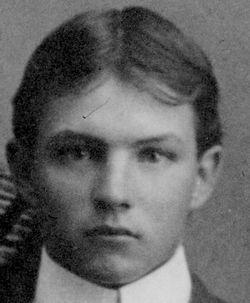
| Description | : | Douglas County Gazette January 1959 Edwin F Zwiebel Edwin F. Zwiebel was born July 20, 1889 in Montra, Shelby County, Ohio. He was the son of Mr. and Mrs. Louis Zwiebel. He came with his parents to Papillion in 1891. The following year the family moved to Waterloo. On march 5, 1913, he was united in marriage to Minnie Seefus near Waterloo. They farmed in this vicinity until January 1944 when they moved to Otoe County where they resided until December 1954 when they retired from farming and moved to their present home in Yutan. He had been in ill health... Read More |
frequently asked questions (FAQ):
-
Where is Edwin Ferdinand Zwiebel's memorial?
Edwin Ferdinand Zwiebel's memorial is located at: Saxilby Cemetery, Saxilby, West Lindsey District, England.
-
When did Edwin Ferdinand Zwiebel death?
Edwin Ferdinand Zwiebel death on 23 Jan 1959 in Omaha, Douglas County, Nebraska, USA
-
Where are the coordinates of the Edwin Ferdinand Zwiebel's memorial?
Latitude: 53.2755800
Longitude: -0.6590400
Family Members:
Parent

Spouse
Siblings
Children
Flowers:


Nearby Cemetories:
1. Saxilby Cemetery
Saxilby, West Lindsey District, England
Coordinate: 53.2755800, -0.6590400
2. St. Botolph Churchyard
Saxilby, West Lindsey District, England
Coordinate: 53.2747300, -0.6591000
3. All Saints Churchyard
Broxholme, West Lindsey District, England
Coordinate: 53.2922400, -0.6349600
4. Sturton by Stow Quaker Cemetery
Sturton-by-Stow, West Lindsey District, England
Coordinate: 53.3173590, -0.6644260
5. Saint Peter And Saint Paul Churchyard
Kettlethorpe, West Lindsey District, England
Coordinate: 53.2714805, -0.7298717
6. Woodbank Cemetery
Skellingthorpe, North Kesteven District, England
Coordinate: 53.2375380, -0.6229660
7. Sturton by Stow
Sturton-by-Stow, West Lindsey District, England
Coordinate: 53.3192800, -0.6677000
8. St. Luke's Churchyard
North Carlton, West Lindsey District, England
Coordinate: 53.2873000, -0.5831200
9. St. John the Baptist Churchyard
South Carlton, West Lindsey District, England
Coordinate: 53.2785000, -0.5754000
10. Stow Cemetery
Stow, West Lindsey District, England
Coordinate: 53.3252100, -0.6811100
11. All Saints Churchyard
Harby, Newark and Sherwood District, England
Coordinate: 53.2242190, -0.6860660
12. St. John the Baptist Churchyard
Scampton, West Lindsey District, England
Coordinate: 53.3037680, -0.5787140
13. St Peter's Churchyard
Aisthorpe, West Lindsey District, England
Coordinate: 53.3102400, -0.5815300
14. St. Peter's Churchyard
Newton on Trent, West Lindsey District, England
Coordinate: 53.2601290, -0.7528380
15. St. Vincent Churchyard
Burton, West Lindsey District, England
Coordinate: 53.2596400, -0.5598100
16. St Cuthbert's Churchyard
Brattleby, West Lindsey District, England
Coordinate: 53.3156600, -0.5794750
17. St. Edith Churchyard
Coates-by-Stow, West Lindsey District, England
Coordinate: 53.3369700, -0.6377300
18. Dam Busters Dog Memorial
Scampton, West Lindsey District, England
Coordinate: 53.3008200, -0.5495800
19. Saint Margaret of Antioch Churchyard
Marton, West Lindsey District, England
Coordinate: 53.3260600, -0.7406500
20. St. Michael's Churchyard
Cammeringham, West Lindsey District, England
Coordinate: 53.3275480, -0.5781450
21. Marton Cemetery
Marton, West Lindsey District, England
Coordinate: 53.3251500, -0.7468200
22. Holy Trinity Churchyard
Cottam, Bassetlaw District, England
Coordinate: 53.3112500, -0.7732600
23. St. Helen's Churchyard
Gate Burton, West Lindsey District, England
Coordinate: 53.3364060, -0.7420920
24. St. Mary's Churchyard
Riseholme, West Lindsey District, England
Coordinate: 53.2688200, -0.5264900