
| Birth | : | 3 Mar 1874 Storm Lake, Buena Vista County, Iowa, USA |
| Death | : | 12 Jun 1963 Missouri Valley, Harrison County, Iowa, USA |
| Burial | : | Branson Cemetery, Loveland, Pottawattamie County, USA |
| Coordinate | : | 41.4846992, -95.8606033 |
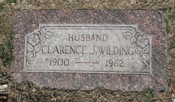
| Inscription | : | Effie May Wilding Mar. 3, 1874 June 12, 1963 |
| Description | : | Services for Mrs. Effie May Wilding, 89, will be held 2 p.m. Friday at the Hennessy-VanCleave Chapel in Missouri Valley. She died Wednesday at a Missouri Valley hospital where she had been a patient since she fractured her hip May 9. The Rev. Howard Dukelow will officiate. Interment will be in Branson Cemetery at Loveland. She was born at Storm Lake and spent her early years in South Dakota. After her marriage she moved to Loveland where she lived most of her life. She is survived by two son, E. T. Wilding of Logan and Howard of Missouri Valley; four... Read More |
frequently asked questions (FAQ):
-
Where is Effie May Dailey Wilding's memorial?
Effie May Dailey Wilding's memorial is located at: Branson Cemetery, Loveland, Pottawattamie County, USA.
-
When did Effie May Dailey Wilding death?
Effie May Dailey Wilding death on 12 Jun 1963 in Missouri Valley, Harrison County, Iowa, USA
-
Where are the coordinates of the Effie May Dailey Wilding's memorial?
Latitude: 41.4846992
Longitude: -95.8606033
Family Members:
Parent

Spouse
Siblings
Children
Flowers:


Nearby Cemetories:
1. Branson Cemetery
Loveland, Pottawattamie County, USA
Coordinate: 41.4846992, -95.8606033
2. Crook Cemetery
Honey Creek, Pottawattamie County, USA
Coordinate: 41.4581330, -95.8737000
3. Saint Bridgets Cemetery
Honey Creek, Pottawattamie County, USA
Coordinate: 41.4664001, -95.8289032
4. Oak Grove Cemetery
Missouri Valley, Harrison County, USA
Coordinate: 41.5167007, -95.8649979
5. Allen Cemetery
Pottawattamie County, USA
Coordinate: 41.4427986, -95.8550034
6. Grange Cemetery
Honey Creek, Pottawattamie County, USA
Coordinate: 41.4446678, -95.8034668
7. Reels Cemetery
Crescent, Pottawattamie County, USA
Coordinate: 41.4234100, -95.8321700
8. William C McIntosh Cemetery
Crescent, Pottawattamie County, USA
Coordinate: 41.4088745, -95.8477097
9. Rose Hill Memorial Gardens
Missouri Valley, Harrison County, USA
Coordinate: 41.5656000, -95.8897000
10. Hurleys Evergreen Cemetery
Harrison County, USA
Coordinate: 41.5700989, -95.8618698
11. Mount Carmel Cemetery
Missouri Valley, Harrison County, USA
Coordinate: 41.5675011, -95.8897018
12. Saint Pauls Lutheran Cemetery
Neola, Pottawattamie County, USA
Coordinate: 41.4337000, -95.7607000
13. Champan Frazier Cemetery
Harrison County, USA
Coordinate: 41.5773500, -95.8933500
14. Frazier Cemetery
Missouri Valley, Harrison County, USA
Coordinate: 41.5932999, -95.8375015
15. Linnwood Cemetery
Harrison County, USA
Coordinate: 41.5589200, -95.7502100
16. Crescent Cemetery
Crescent, Pottawattamie County, USA
Coordinate: 41.3664894, -95.8566208
17. Shipley Cemetery
Washington County, USA
Coordinate: 41.3932991, -95.9828033
18. Fort Calhoun Cemetery
Fort Calhoun, Washington County, USA
Coordinate: 41.4581375, -96.0352020
19. Harris Grove Cemetery
Beebeetown, Harrison County, USA
Coordinate: 41.5782928, -95.7262192
20. Hazel Dell Cemetery
Council Bluffs, Pottawattamie County, USA
Coordinate: 41.3489723, -95.7939911
21. Castor Cemetery
Underwood, Pottawattamie County, USA
Coordinate: 41.4127040, -95.6887490
22. Calhoun Cemetery
Calhoun, Harrison County, USA
Coordinate: 41.6391983, -95.8938980
23. Gregg Cemetery
Weston, Pottawattamie County, USA
Coordinate: 41.3330000, -95.7931000
24. Evans Cemetery
Crescent, Pottawattamie County, USA
Coordinate: 41.3255997, -95.8368988