
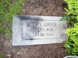
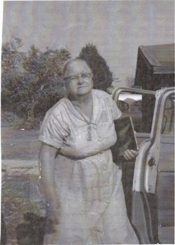
Eliza Ann Smith Gunter
| Birth | : | 20 Oct 1858 South Carolina, USA |
| Death | : | 4 Jan 1944 Lexington, Lexington County, South Carolina, USA |
| Burial | : | St Firmin Churchyard, Thurlby, South Kesteven District, England |
| Coordinate | : | 52.7375960, -0.3646650 |
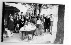
| Description | : | Anna Eliza Smith Gunter was born to John Adam Smith and Mary Magdaline Gruber in Lexington SC, the youngest of 12 children. She married Jacob Franklin Gunter and they had 11 children, Charles, Rosanna Catherine, Jane Catherine(my g grandmother), Lee Jason, Effie Estelle, George Washington,Elvin Caleb, Jessie David, Emanuel, Arthur, Franklin. The story about grandma Eliza that I am told is that she was a very tall big woman, she went out to bring in some wood for the fire in January. There was some snow on the ground, she slipped and fell across the wood pile and could not get up,... Read More |
frequently asked questions (FAQ):
-
Where is Eliza Ann Smith Gunter's memorial?
Eliza Ann Smith Gunter's memorial is located at: St Firmin Churchyard, Thurlby, South Kesteven District, England.
-
When did Eliza Ann Smith Gunter death?
Eliza Ann Smith Gunter death on 4 Jan 1944 in Lexington, Lexington County, South Carolina, USA
-
Where are the coordinates of the Eliza Ann Smith Gunter's memorial?
Latitude: 52.7375960
Longitude: -0.3646650
Family Members:
Parent
Spouse

Siblings

Children
Flowers:


Nearby Cemetories:
1. St Firmin Churchyard
Thurlby, South Kesteven District, England
Coordinate: 52.7375960, -0.3646650
2. Bourne Cemetery
Bourne, South Kesteven District, England
Coordinate: 52.7607264, -0.3714663
3. Baston Cemetery
Baston, South Kesteven District, England
Coordinate: 52.7149917, -0.3531338
4. St John the Baptist Churchyard
Baston, South Kesteven District, England
Coordinate: 52.7149530, -0.3530650
5. Bourne Abbey
Bourne, South Kesteven District, England
Coordinate: 52.7661320, -0.3758389
6. St Faith Churchyard
Wilsthorpe, South Kesteven District, England
Coordinate: 52.7095208, -0.3848166
7. St Michael and All Angels Churchyard
Langtoft, South Kesteven District, England
Coordinate: 52.6990300, -0.3389800
8. St. Andrews Churchyard
Witham on the Hill, South Kesteven District, England
Coordinate: 52.7364500, -0.4420300
9. St Martin Churchyard
Barholm, South Kesteven District, England
Coordinate: 52.6855000, -0.3887600
10. Saint Stephen
Carlby, South Kesteven District, England
Coordinate: 52.7125650, -0.4475800
11. St Michael Churchyard
Edenham, South Kesteven District, England
Coordinate: 52.7836110, -0.4266560
12. St Mary Magdalene Churchyard
Essendine, Rutland Unitary Authority, England
Coordinate: 52.7026000, -0.4489000
13. St Medard and St Gildard Churchyard
Little Bytham, South Kesteven District, England
Coordinate: 52.6786110, -0.3200000
14. St John the Baptist Churchyard
Morton, South Kesteven District, England
Coordinate: 52.8025100, -0.3724200
15. St Stephen Churchyard
Careby, South Kesteven District, England
Coordinate: 52.7363500, -0.4823700
16. St. Andrew's Churchyard
West Deeping, South Kesteven District, England
Coordinate: 52.6640285, -0.3614634
17. St Andrew's Churchyard
Haconby, South Kesteven District, England
Coordinate: 52.8135400, -0.3594300
18. St. James Cemetery
Deeping St James, South Kesteven District, England
Coordinate: 52.6716340, -0.2899500
19. St. James Churchyard
Deeping St James, South Kesteven District, England
Coordinate: 52.6716980, -0.2896360
20. St. Peter's Churchyard
Maxey, Peterborough Unitary Authority, England
Coordinate: 52.6575500, -0.3455940
21. St. Lawrence's Churchyard
Tallington, South Kesteven District, England
Coordinate: 52.6574520, -0.3879120
22. Ryhall Churchyard Extension
Ryhall, Rutland Unitary Authority, England
Coordinate: 52.6849000, -0.4678700
23. St John the Evangelist Churchyard
Ryhall, Rutland Unitary Authority, England
Coordinate: 52.6852000, -0.4685000
24. St Peter Churchyard
Creeton, South Kesteven District, England
Coordinate: 52.7669500, -0.4977300