
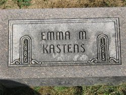
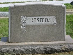
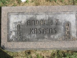
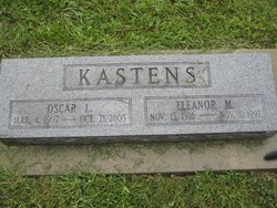
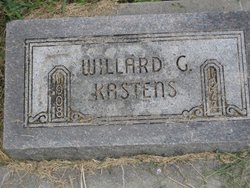
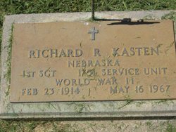
Emma M. Kastens
| Birth | : | 1886 |
| Death | : | 1953 |
| Burial | : | Leek Cemetery, Leek, Staffordshire Moorlands District, England |
| Coordinate | : | 53.1000880, -2.0248680 |
| Plot | : | Section B |
frequently asked questions (FAQ):
-
Where is Emma M. Kastens's memorial?
Emma M. Kastens's memorial is located at: Leek Cemetery, Leek, Staffordshire Moorlands District, England.
-
When did Emma M. Kastens death?
Emma M. Kastens death on 1953 in
-
Where are the coordinates of the Emma M. Kastens's memorial?
Latitude: 53.1000880
Longitude: -2.0248680
Family Members:
Parent
Spouse
Siblings

Children
Flowers:


Nearby Cemetories:
1. Leek Cemetery
Leek, Staffordshire Moorlands District, England
Coordinate: 53.1000880, -2.0248680
2. St Edward the Confessor Churchyard
Leek, Staffordshire Moorlands District, England
Coordinate: 53.1068190, -2.0266150
3. St Luke Churchyard
Leek, Staffordshire Moorlands District, England
Coordinate: 53.1061400, -2.0191430
4. Buxton Road Cemetery
Leek, Staffordshire Moorlands District, England
Coordinate: 53.1154780, -2.0029690
5. St Chad Churchyard
Longsdon, Staffordshire Moorlands District, England
Coordinate: 53.0887220, -2.0625850
6. St Edwards Lawn Cemetery
Cheddleton, Staffordshire Moorlands District, England
Coordinate: 53.0744437, -2.0385063
7. St Edward the Confessor Churchyard
Cheddleton, Staffordshire Moorlands District, England
Coordinate: 53.0689530, -2.0448230
8. St. Michael and All Angels Churchyard
Horton, Staffordshire Moorlands District, England
Coordinate: 53.1135330, -2.0879040
9. St. Michael's Churchyard Extension
Horton, Staffordshire Moorlands District, England
Coordinate: 53.1139430, -2.0878020
10. St. Matthew's Churchyard
Meerbrook, Staffordshire Moorlands District, England
Coordinate: 53.1446350, -2.0177810
11. St. Luke's Churchyard
Endon, Staffordshire Moorlands District, England
Coordinate: 53.0812200, -2.1086100
12. St. Luke Churchyard
Onecote, Staffordshire Moorlands District, England
Coordinate: 53.0935720, -1.9289360
13. St John the Baptist Churchyard
Wetley Rocks, Staffordshire Moorlands District, England
Coordinate: 53.0409100, -2.0555020
14. St Chad Churchyard
Bagnall, Staffordshire Moorlands District, England
Coordinate: 53.0558430, -2.1082770
15. St Lawrence Churchyard
Rushton Spencer, Staffordshire Moorlands District, England
Coordinate: 53.1556630, -2.0996440
16. Christ Church Churchyard
Biddulph Moor, Staffordshire Moorlands District, England
Coordinate: 53.1220780, -2.1402320
17. St Anne Churchyard
Brown Edge, Staffordshire Moorlands District, England
Coordinate: 53.0832490, -2.1429880
18. St. Mark the Evangelist Churchyard
Foxt, Staffordshire Moorlands District, England
Coordinate: 53.0362440, -1.9473820
19. St. Werburgh Churchyard
Kingsley, Staffordshire Moorlands District, England
Coordinate: 53.0195390, -1.9815730
20. Baptist Chapel Churchyard Cemetery
Walkern, East Hertfordshire District, England
Coordinate: 53.0228400, -1.9644900
21. St. Philip and St. James Churchyard
Milton, Stoke-on-Trent Unitary Authority, England
Coordinate: 53.0503730, -2.1403780
22. St. Bartholomew's Churchyard
Butterton, Staffordshire Moorlands District, England
Coordinate: 53.1062600, -1.8814800
23. Carmountside Cemetery and Crematorium
Milton, Stoke-on-Trent Unitary Authority, England
Coordinate: 53.0449570, -2.1394910
24. St. Lawrence Churchyard
Biddulph, Staffordshire Moorlands District, England
Coordinate: 53.1281320, -2.1659070