
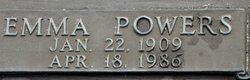
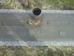
Emma Powers Jones
| Birth | : | 22 Jan 1909 Brittons Neck, Marion County, South Carolina, USA |
| Death | : | 18 Apr 1986 West Columbia, Lexington County, South Carolina, USA |
| Burial | : | St Margaret of Antioch Churchyard, Ifield, Crawley Borough, England |
| Coordinate | : | 51.1238700, -0.2194760 |
frequently asked questions (FAQ):
-
Where is Emma Powers Jones's memorial?
Emma Powers Jones's memorial is located at: St Margaret of Antioch Churchyard, Ifield, Crawley Borough, England.
-
When did Emma Powers Jones death?
Emma Powers Jones death on 18 Apr 1986 in West Columbia, Lexington County, South Carolina, USA
-
Where are the coordinates of the Emma Powers Jones's memorial?
Latitude: 51.1238700
Longitude: -0.2194760
Family Members:
Parent

Spouse
Siblings
Children

Flowers:


Nearby Cemetories:
1. St Margaret of Antioch Churchyard
Ifield, Crawley Borough, England
Coordinate: 51.1238700, -0.2194760
2. Friends Meeting House
Ifield, Crawley Borough, England
Coordinate: 51.1263400, -0.2120200
3. Snell Hatch Cemetery
Crawley, Crawley Borough, England
Coordinate: 51.1164130, -0.2053970
4. St John the Baptist Church
Crawley, Crawley Borough, England
Coordinate: 51.1140840, -0.1892240
5. Friary Churchyard of St. Francis and St. Anthony
Crawley, Crawley Borough, England
Coordinate: 51.1133670, -0.1875970
6. Charlwood Friends Burial Ground
Charlwood, Mole Valley District, England
Coordinate: 51.1553700, -0.2305800
7. Saint Mary Magdalene Churchyard
Rusper, Horsham District, England
Coordinate: 51.1227750, -0.2789080
8. St Saviour Churchyard
Colgate, Horsham District, England
Coordinate: 51.0817080, -0.2444000
9. Surrey and Sussex Crematorium
Crawley, Crawley Borough, England
Coordinate: 51.1357000, -0.1469230
10. St Nicholas Churchyard
Worth, Mid Sussex District, England
Coordinate: 51.1102870, -0.1415280
11. St. Bartholomew's Churchyard
Horley, Reigate and Banstead Borough, England
Coordinate: 51.1698000, -0.1758000
12. Parish of Horley's New Churchyard
Horley, Reigate and Banstead Borough, England
Coordinate: 51.1711120, -0.1747610
13. St Peter Churchyard
Newdigate, Mole Valley District, England
Coordinate: 51.1652200, -0.2884860
14. Pleystowe in Capel Friends Grounds
Capel, Mole Valley District, England
Coordinate: 51.1411900, -0.3161300
15. St John the Evangelist Churchyard
Copthorne, Crawley Borough, England
Coordinate: 51.1394100, -0.1175700
16. Roffey Cemetery
Horsham, Horsham District, England
Coordinate: 51.0769320, -0.2930890
17. St Bartholomew Churchyard
Burstow, Tandridge District, England
Coordinate: 51.1558610, -0.1247750
18. Capel Friends Burial Ground #2
Capel, Mole Valley District, England
Coordinate: 51.1513970, -0.3219210
19. St. John the Baptist Churchyard
Capel, Mole Valley District, England
Coordinate: 51.1539730, -0.3201980
20. St Mary's Churchyard
Balcombe, Mid Sussex District, England
Coordinate: 51.0626380, -0.1362240
21. St John The Evangelist Churchyard
Lower Beeding, Horsham District, England
Coordinate: 51.0552500, -0.2889280
22. St Leonard's Church
Turners Hill, Mid Sussex District, England
Coordinate: 51.1023030, -0.0911310
23. Smallfield Ebenezer Chapel Cemetery
Smallfield, Tandridge District, England
Coordinate: 51.1770230, -0.1151960
24. Sidlow Bridge Emmanuel Churchyard
Sidlow, Reigate and Banstead Borough, England
Coordinate: 51.2077270, -0.1989510