

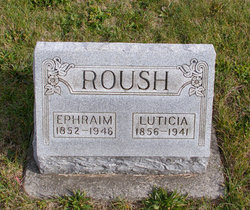
Ephraim Roush
| Birth | : | 6 Mar 1852 Pennsylvania, USA |
| Death | : | 15 Mar 1946 Allen County, Ohio, USA |
| Burial | : | Christ Church Churchyard Westerdale, Westerdale, Scarborough Borough, England |
| Coordinate | : | 54.4450870, -0.9781360 |
frequently asked questions (FAQ):
-
Where is Ephraim Roush's memorial?
Ephraim Roush's memorial is located at: Christ Church Churchyard Westerdale, Westerdale, Scarborough Borough, England.
-
When did Ephraim Roush death?
Ephraim Roush death on 15 Mar 1946 in Allen County, Ohio, USA
-
Where are the coordinates of the Ephraim Roush's memorial?
Latitude: 54.4450870
Longitude: -0.9781360
Family Members:
Parent
Spouse
Siblings

Children
Flowers:


Nearby Cemetories:
1. Christ Church Churchyard Westerdale
Westerdale, Scarborough Borough, England
Coordinate: 54.4450870, -0.9781360
2. Westerdale Green Burial Ground
Westerdale, Scarborough Borough, England
Coordinate: 54.4409040, -0.9555864
3. Quakers Burial Ground
Castleton, Scarborough Borough, England
Coordinate: 54.4614010, -0.9478360
4. St Hilda Churchyard
Danby, Scarborough Borough, England
Coordinate: 54.4475240, -0.9281480
5. Botton Village Cemetery
Danby, Scarborough Borough, England
Coordinate: 54.4290000, -0.9282700
6. St Peter Churchyard
Commondale, Scarborough Borough, England
Coordinate: 54.4863700, -0.9766200
7. St Cuthbert Churchyard
Kildale, Hambleton District, England
Coordinate: 54.4779100, -1.0689200
8. St. Andrew's Churchyard
Ingleby Greenhow, Hambleton District, England
Coordinate: 54.4487300, -1.1051300
9. St Mary Churchyard
Farndale East, Ryedale District, England
Coordinate: 54.3693000, -0.9663000
10. St. Nicholas' Churchyard
Bransdale, Ryedale District, England
Coordinate: 54.3777000, -1.0464000
11. St Mary Churchyard
Moorsholm, Redcar and Cleveland Unitary Authority, England
Coordinate: 54.5207800, -0.9375800
12. Emerson Family Mausoleum
Easby, Hambleton District, England
Coordinate: 54.4702280, -1.1098760
13. Glaisdale Head Methodist Church
Glaisdale, Scarborough Borough, England
Coordinate: 54.4294940, -0.8331749
14. Quaker Burial Ground
Lealholm, Scarborough Borough, England
Coordinate: 54.4575270, -0.8285030
15. St James the Greater Churchyard
Lealholm, Scarborough Borough, England
Coordinate: 54.4586200, -0.8240300
16. Our Lady of Sacred Heart Roman Catholic Churchyard
Lealholm, Scarborough Borough, England
Coordinate: 54.4592200, -0.8234600
17. St Aidan Churchyard
Boosbeck, Redcar and Cleveland Unitary Authority, England
Coordinate: 54.5428560, -0.9786800
18. Boosbeck Cemetery
Boosbeck, Redcar and Cleveland Unitary Authority, England
Coordinate: 54.5434900, -0.9779200
19. Friends Burial Ground
Great Ayton, Hambleton District, England
Coordinate: 54.4880800, -1.1315580
20. St Thomas Churchyard
Glaisdale, Scarborough Borough, England
Coordinate: 54.4373700, -0.8083400
21. St. Hilda's Churchyard
Chop Gate, Hambleton District, England
Coordinate: 54.3988950, -1.1299120
22. Guisborough Priory
Guisborough, Redcar and Cleveland Unitary Authority, England
Coordinate: 54.5361700, -1.0489500
23. St. Nicholas Churchyard
Guisborough, Redcar and Cleveland Unitary Authority, England
Coordinate: 54.5366500, -1.0482800
24. Quakers Burial Ground
Guisborough, Redcar and Cleveland Unitary Authority, England
Coordinate: 54.5355100, -1.0569760