

Ernest Howard Hoober
| Birth | : | 5 Mar 1930 Crisfield, Harper County, Kansas, USA |
| Death | : | 1 Jul 1930 Crisfield, Harper County, Kansas, USA |
| Burial | : | St. Mary the Virgin Churchyard, Eling, New Forest District, England |
| Coordinate | : | 50.9103000, -1.4795700 |
| Plot | : | Lot 106, Sp 2 |
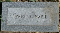
| Description | : | Last born child of Pearl Cockrell and Augustus Hoober. Shares stone with first born child, Marie. |
frequently asked questions (FAQ):
-
Where is Ernest Howard Hoober's memorial?
Ernest Howard Hoober's memorial is located at: St. Mary the Virgin Churchyard, Eling, New Forest District, England.
-
When did Ernest Howard Hoober death?
Ernest Howard Hoober death on 1 Jul 1930 in Crisfield, Harper County, Kansas, USA
-
Where are the coordinates of the Ernest Howard Hoober's memorial?
Latitude: 50.9103000
Longitude: -1.4795700
Family Members:
Parent
Siblings


Flowers:


Nearby Cemetories:
1. Eling Cemetery
Eling, New Forest District, England
Coordinate: 50.9092640, -1.4817810
2. Holy Trinity Churchyard
Millbrook, Southampton Unitary Authority, England
Coordinate: 50.9158400, -1.4535100
3. Millbrook Cemetery
Millbrook, Southampton Unitary Authority, England
Coordinate: 50.9164900, -1.4526100
4. Christ Church Churchyard
Ashurst, New Forest District, England
Coordinate: 50.8960200, -1.5054200
5. St. Nicholas Churchyard
Millbrook, Southampton Unitary Authority, England
Coordinate: 50.9139100, -1.4439800
6. St John the Apostle Churchyard
Marchwood, New Forest District, England
Coordinate: 50.8900300, -1.4530700
7. Falklands War Memorial
Marchwood, New Forest District, England
Coordinate: 50.8898280, -1.4533250
8. St. Matthew's Churchyard
Netley Marsh, New Forest District, England
Coordinate: 50.9161620, -1.5285530
9. St James by the Park Churchyard
Shirley, Southampton Unitary Authority, England
Coordinate: 50.9266800, -1.4285800
10. St. James by the Park Cemetery
Southampton Unitary Authority, England
Coordinate: 50.9267988, -1.4283898
11. St Boniface Churchyard
Nursling, Test Valley Borough, England
Coordinate: 50.9464660, -1.4896760
12. Hollybrook War Memorial
Southampton, Southampton Unitary Authority, England
Coordinate: 50.9337420, -1.4311350
13. Hollybrook Cemetery
Southampton, Southampton Unitary Authority, England
Coordinate: 50.9340680, -1.4312970
14. Southampton Old Cemetery
Southampton, Southampton Unitary Authority, England
Coordinate: 50.9202900, -1.4130650
15. All Saints Churchyard
Dibden, New Forest District, England
Coordinate: 50.8753020, -1.4362590
16. St John the Evangelist Churchyard
Rownhams, Test Valley Borough, England
Coordinate: 50.9520900, -1.4541200
17. St Michael the Archangel Churchyard
Southampton, Southampton Unitary Authority, England
Coordinate: 50.8996200, -1.4056900
18. St Lawrence with St John Churchyard
Southampton, Southampton Unitary Authority, England
Coordinate: 50.8977570, -1.4052470
19. Holyrood Churchyard
Southampton, Southampton Unitary Authority, England
Coordinate: 50.8996600, -1.4035300
20. Holyrood Church
Southampton Unitary Authority, England
Coordinate: 50.8997498, -1.4034560
21. All Saints Catacombs and Burial Ground (Defunct)
Southampton, Southampton Unitary Authority, England
Coordinate: 50.9013350, -1.4021500
22. St. Julien's Church
Southampton, Southampton Unitary Authority, England
Coordinate: 50.8965000, -1.4036000
23. St Mary Churchyard
Southampton, Southampton Unitary Authority, England
Coordinate: 50.9027100, -1.3960800
24. Highfield Churchyard
Portswood, Southampton Unitary Authority, England
Coordinate: 50.9295400, -1.3949800