| Birth | : | 9 Sep 1867 Saint Helena, Cedar County, Nebraska, USA |
| Death | : | 18 Jun 1939 Fordyce, Cedar County, Nebraska, USA |
| Burial | : | Topeka Cemetery, Topeka, Shawnee County, USA |
| Coordinate | : | 39.0388985, -95.6528015 |
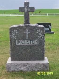
| Description | : | The Cedar County News, Hartington, NE, Thursday, June 22, 1939 FRANK HOCHSTEIN DIES AT FORDYCE WAS A CEDAR COUNTY RESIDENT FOR SEVENTY-TWO YEARS Death came Sunday morning to relieve the suffering of Frank Hochstein, well known retired farmer of the Fordyce Community when he passed away at the family home about 8:30 am. Mr. Hochstein was a resident of Cedar county his entire life, having been born September 9, 1867 at St. Helena, the son of Frank and Josephine Hochstein. During his 72 years he was Cedar county grown from the unsettled prairie to one of the farming... Read More |
frequently asked questions (FAQ):
-
Where is Frank Hochstein's memorial?
Frank Hochstein's memorial is located at: Topeka Cemetery, Topeka, Shawnee County, USA.
-
When did Frank Hochstein death?
Frank Hochstein death on 18 Jun 1939 in Fordyce, Cedar County, Nebraska, USA
-
Where are the coordinates of the Frank Hochstein's memorial?
Latitude: 39.0388985
Longitude: -95.6528015
Family Members:
Parent
Spouse
Siblings
Children
Flowers:
Nearby Cemetories:
1. Topeka Cemetery
Topeka, Shawnee County, USA
Coordinate: 39.0388985, -95.6528015
2. Mount Auburn Cemetery
Topeka, Shawnee County, USA
Coordinate: 39.0393982, -95.6500015
3. Grace Episcopal Cathedral Sanctuary
Topeka, Shawnee County, USA
Coordinate: 39.0506925, -95.6839273
4. Grace Episcopal Cathedral Columbarium
Topeka, Shawnee County, USA
Coordinate: 39.0511284, -95.6843719
5. Carnegie Hall
Topeka, Shawnee County, USA
Coordinate: 39.0350600, -95.6999100
6. Westminster Presbyterian Church Memorial Garden
Topeka, Shawnee County, USA
Coordinate: 39.0430400, -95.7021700
7. Ritchie Cemetery
Topeka, Shawnee County, USA
Coordinate: 39.0228010, -95.7027530
8. Curtis Family Cemetery
North Topeka, Shawnee County, USA
Coordinate: 39.0792870, -95.6702270
9. Topeka State Hospital Cemetery
Topeka, Shawnee County, USA
Coordinate: 39.0671005, -95.7080994
10. Saint Davids Episcopal Church Columbarium
Topeka, Shawnee County, USA
Coordinate: 39.0369860, -95.7259480
11. Memorial Park Cemetery
Topeka, Shawnee County, USA
Coordinate: 39.0619011, -95.7221985
12. Bethel Cemetery
Topeka, Shawnee County, USA
Coordinate: 39.0085983, -95.5864029
13. Foster Cemetery
Topeka, Shawnee County, USA
Coordinate: 38.9942017, -95.7061005
14. Mount Calvary Cemetery
Topeka, Shawnee County, USA
Coordinate: 39.0532990, -95.7360992
15. Mount Hope Cemetery
Topeka, Shawnee County, USA
Coordinate: 39.0367393, -95.7386703
16. Bennie Lee Graham Memorial Cemetery
Shawnee County, USA
Coordinate: 39.1020584, -95.6836472
17. Rochester Cemetery
Topeka, Shawnee County, USA
Coordinate: 39.1044006, -95.6800003
18. Bauer Cemetery
Topeka, Shawnee County, USA
Coordinate: 38.9864006, -95.5764008
19. Old Grantville Cemetery
Grantville, Jefferson County, USA
Coordinate: 39.0949500, -95.5771300
20. Lynn Creek Cemetery
Berryton, Shawnee County, USA
Coordinate: 38.9575005, -95.6408005
21. Grantville Cemetery
Grantville, Jefferson County, USA
Coordinate: 39.0957400, -95.5745800
22. Security Benefit Association Cemetery
Topeka, Shawnee County, USA
Coordinate: 39.0630989, -95.7606583
23. Emmanuel Cemetery
Watson, Shawnee County, USA
Coordinate: 38.9719009, -95.5744019
24. Abram Burnett Burial Site
Topeka, Shawnee County, USA
Coordinate: 39.0102997, -95.7685776


