
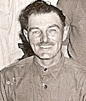


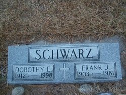
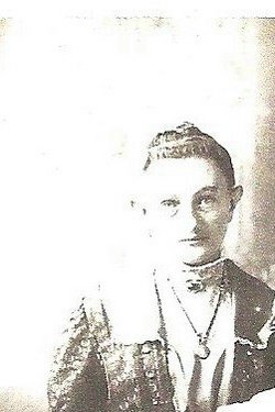
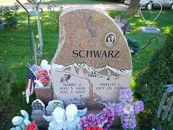
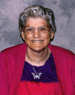
Frank Jokum Schwarz
| Birth | : | 31 Mar 1903 Smithfield, Gosper County, Nebraska, USA |
| Death | : | 4 Nov 1981 Lexington, Dawson County, Nebraska, USA |
| Burial | : | St. Bartholomew's Churchyard, Failand, North Somerset Unitary Authority, England |
| Coordinate | : | 51.4584000, -2.7000000 |
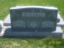
| Plot | : | DIV. C, BLOCK 46, SPACE 1. |
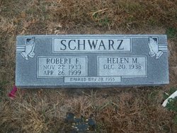
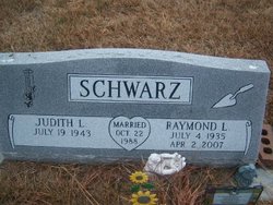
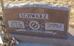
| Description | : | Frank J. Schwarz, 78, died Wednesday at his home in Lexington. He was born March 31, 1903, in Smithfield. Survivors includes his wife, Dorothy of Lexington; eight sons, Harry of Loveland, CO., Cark, Robert, Raymond, Martin and Keith all of Lexington, Kenny of Elwood and Eugene of Elm Creek; two daughers, Mrs. Alice Wendburg and Mrs. Martha Hubbard, both of Lexington; two sisters, Mrs. Rosa Woodside of Lexington and mrs. Elsi Ropers of Sargent: 41 grandchildren; and 10 great-grandchildren. Christian wake services were Friday at 8 p.m. at St. Ann's Catholic Church. Mass of Christian Burial was celebrated Saturday 10 a.m. at... Read More |
frequently asked questions (FAQ):
-
Where is Frank Jokum Schwarz's memorial?
Frank Jokum Schwarz's memorial is located at: St. Bartholomew's Churchyard, Failand, North Somerset Unitary Authority, England.
-
When did Frank Jokum Schwarz death?
Frank Jokum Schwarz death on 4 Nov 1981 in Lexington, Dawson County, Nebraska, USA
-
Where are the coordinates of the Frank Jokum Schwarz's memorial?
Latitude: 51.4584000
Longitude: -2.7000000
Family Members:
Parent
Spouse

Siblings


Children
Flowers:


Nearby Cemetories:
1. St. Bartholomew's Churchyard
Failand, North Somerset Unitary Authority, England
Coordinate: 51.4584000, -2.7000000
2. Tyntesfield House Chapel
Wraxall, North Somerset Unitary Authority, England
Coordinate: 51.4407400, -2.7110500
3. Saint George Churchyard
Easton-in-Gordano, North Somerset Unitary Authority, England
Coordinate: 51.4785490, -2.7013400
4. Saint Mary's the Virgin Churchyard
Portbury, North Somerset Unitary Authority, England
Coordinate: 51.4756000, -2.7173000
5. All Saints Churchyard
Wraxall, North Somerset Unitary Authority, England
Coordinate: 51.4444000, -2.7348000
6. Holy Trinity Churchyard
Abbots Leigh, North Somerset Unitary Authority, England
Coordinate: 51.4631600, -2.6573300
7. Shirehampton Cemetery
Shirehampton, Bristol Unitary Authority, England
Coordinate: 51.4895290, -2.6797050
8. St Michael & All Angels
Flax Bourton, North Somerset Unitary Authority, England
Coordinate: 51.4212620, -2.7109840
9. All Saints Churchyard
Long Ashton, North Somerset Unitary Authority, England
Coordinate: 51.4358100, -2.6439400
10. Saint Michael Churchyard
Clapton-in-Gordano, North Somerset Unitary Authority, England
Coordinate: 51.4583000, -2.7673000
11. St. Mary Magdalene Churchyard
Stoke Bishop, Bristol Unitary Authority, England
Coordinate: 51.4767100, -2.6356800
12. Ss Mary and Edward Churchyard
Barrow Gurney, North Somerset Unitary Authority, England
Coordinate: 51.4130630, -2.6989510
13. Nailsea Garden of Rest
Nailsea, North Somerset Unitary Authority, England
Coordinate: 51.4340540, -2.7613880
14. Christ Church Churchyard
Nailsea, North Somerset Unitary Authority, England
Coordinate: 51.4336490, -2.7612050
15. Portishead Cemetery
Portishead, North Somerset Unitary Authority, England
Coordinate: 51.4720380, -2.7737220
16. Hope Chapel
Clifton, Bristol Unitary Authority, England
Coordinate: 51.4512800, -2.6216000
17. Saint Peter Churchyard
Portishead, North Somerset Unitary Authority, England
Coordinate: 51.4806130, -2.7709270
18. Christ Church Cemetery
Clifton, Bristol Unitary Authority, England
Coordinate: 51.4576220, -2.6200000
19. St. Andrew's Churchyard
Backwell, North Somerset Unitary Authority, England
Coordinate: 51.4118600, -2.7297400
20. Clifton Cathedral
Clifton, Bristol Unitary Authority, England
Coordinate: 51.4596870, -2.6163140
21. St. Andrew's Churchyard
Clifton, Bristol Unitary Authority, England
Coordinate: 51.4543810, -2.6147460
22. Holy Trinity Churchyard
Nailsea, North Somerset Unitary Authority, England
Coordinate: 51.4258140, -2.7692830
23. Ss Quiricus & Julietta Churchyard
Tickenham, North Somerset Unitary Authority, England
Coordinate: 51.4394000, -2.7814000
24. Canford Cemetery and Crematorium
Westbury-on-Trym, Bristol Unitary Authority, England
Coordinate: 51.4946810, -2.6269490