

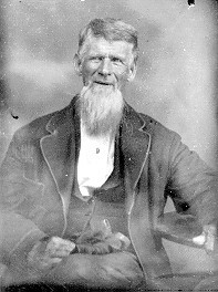
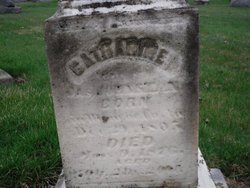
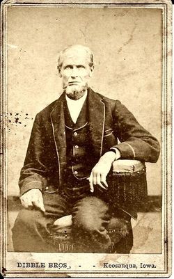
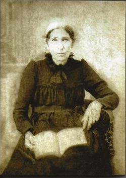
George Miller
| Birth | : | 5 Oct 1774 Rockingham County, Virginia, USA |
| Death | : | 29 Jan 1855 Van Buren County, Iowa, USA |
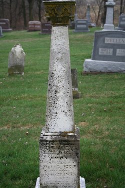
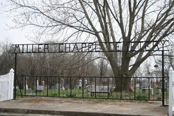
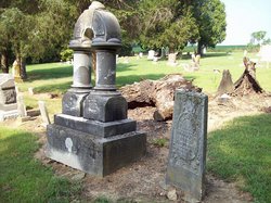
| Burial | : | Springhill MB Church Cemetery, Eaton, Gibson County, USA |
| Coordinate | : | 35.9871860, -89.1210420 |
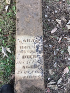
| Inscription | : | "The pains of death are past, Labor and sorrow cease, And life's long warfare closed at last. His soul is found in peace." |
| Description | : | Following the death of George's first wife Elizabeth, George married Nancy Ragsdale on September 08, 1851 in Van Buren Co., IA. |
frequently asked questions (FAQ):
-
Where is George Miller's memorial?
George Miller's memorial is located at: Springhill MB Church Cemetery, Eaton, Gibson County, USA.
-
When did George Miller death?
George Miller death on 29 Jan 1855 in Van Buren County, Iowa, USA
-
Where are the coordinates of the George Miller's memorial?
Latitude: 35.9871860
Longitude: -89.1210420
Family Members:
Parent
Spouse
Siblings

Children
Flowers:


Nearby Cemetories:
1. Springhill MB Church Cemetery
Eaton, Gibson County, USA
Coordinate: 35.9871860, -89.1210420
2. Spring Hill Baptist Church Cemetery
Eaton, Gibson County, USA
Coordinate: 35.9859520, -89.1221080
3. Wilson Cemetery
Gibson County, USA
Coordinate: 35.9706001, -89.0980988
4. Concidine Gravesite
Gibson County, USA
Coordinate: 35.9930000, -89.0800000
5. Walnut Grove Cemetery
Trenton, Gibson County, USA
Coordinate: 35.9947014, -89.0764008
6. Old Mayfield Cemetery
Eaton, Gibson County, USA
Coordinate: 35.9894960, -89.1666780
7. Mayfield Cemetery
Eaton, Gibson County, USA
Coordinate: 35.9910230, -89.1678300
8. Roberts Family Cemetery
Eaton, Gibson County, USA
Coordinate: 35.9882200, -89.0734100
9. Salem Primitive Baptist Cemetery
Hickory Grove, Gibson County, USA
Coordinate: 35.9681400, -89.0709700
10. Olive Branch Methodist Church Cemetery
Eaton, Gibson County, USA
Coordinate: 35.9678001, -89.0607986
11. Elizabeth Methodist Church Cemetery
Elizabeth, Crockett County, USA
Coordinate: 35.9605010, -89.1770140
12. Bethesda Cemetery
Wilcox, Crockett County, USA
Coordinate: 35.9361230, -89.1557970
13. Young & Williams Cemetery
Elizabeth, Crockett County, USA
Coordinate: 35.9707990, -89.1937240
14. Hogue Cemetery
Yorkville, Gibson County, USA
Coordinate: 36.0495580, -89.0985780
15. Balentine Family Cemetery
Dyer, Gibson County, USA
Coordinate: 36.0544690, -89.0928070
16. Shaw Cemetery
Tatumville, Dyer County, USA
Coordinate: 36.0435982, -89.1868973
17. Hall Family Cemetery
Dyer, Gibson County, USA
Coordinate: 36.0302900, -89.0393600
18. Duck Hill Cemetery
Trenton, Gibson County, USA
Coordinate: 36.0331001, -89.0413971
19. Hartsfield Cemetery
Gibson County, USA
Coordinate: 35.9155500, -89.0721100
20. Mays Chapel Cemetery
Friendship, Crockett County, USA
Coordinate: 35.9363540, -89.2006050
21. Warren Cemetery
Crockett Mills, Crockett County, USA
Coordinate: 35.9074790, -89.1521770
22. Williams Chapel Baptist Church Cemetery
Friendship, Crockett County, USA
Coordinate: 35.9258940, -89.1916320
23. Sanders Cemetery
Crockett Mills, Crockett County, USA
Coordinate: 35.9096750, -89.1609030
24. Ward's Grove C.M.E. Church Cemetery
Trenton, Gibson County, USA
Coordinate: 35.9097929, -89.0770110