

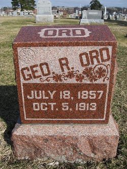
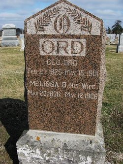
George Ridman Ord II
| Birth | : | 18 Jul 1857 Wisconsin, USA |
| Death | : | 5 Oct 1913 Pawnee City, Pawnee County, Nebraska, USA |
| Burial | : | Carlton Cemetery, Nottingham, Nottingham Unitary Authority, England |
| Coordinate | : | 52.9682820, -1.0900230 |
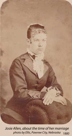
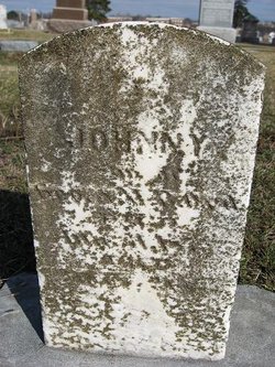
| Description | : | Married Dec. 16, 1880 to Josephine Allen. Three children were born to this union, Venus Grace, Elwood Ralph & Mabel Josephine. Remarried Sept. 29, to Anna Fuller. George and Anna buried a child named Frankie at Union Baptist Cemetery, Pleasant Hill, Cass Co., MO. The family is enumerated there in the 1900 census. Additional children, aside from Gladys, were Harold (b Jul 1892)and Emma (b. Aug 1896). John (b. 1901)is with the family in Pawnee, NE in 1910. Later, brothers Harold and John were living in NE with the Moon family. I obtained Frankie's information from a book... Read More |
frequently asked questions (FAQ):
-
Where is George Ridman Ord II's memorial?
George Ridman Ord II's memorial is located at: Carlton Cemetery, Nottingham, Nottingham Unitary Authority, England.
-
When did George Ridman Ord II death?
George Ridman Ord II death on 5 Oct 1913 in Pawnee City, Pawnee County, Nebraska, USA
-
Where are the coordinates of the George Ridman Ord II's memorial?
Latitude: 52.9682820
Longitude: -1.0900230
Family Members:
Parent

Spouse
Siblings

Children

Flowers:


Nearby Cemetories:
1. Carlton Cemetery
Nottingham, Nottingham Unitary Authority, England
Coordinate: 52.9682820, -1.0900230
2. All Hallows Churchyard
Gedling, Gedling Borough, England
Coordinate: 52.9769400, -1.0805130
3. Gedling Cemetery
Gedling, Gedling Borough, England
Coordinate: 52.9806930, -1.0870670
4. St. Paul's Churchyard
Nottingham Unitary Authority, England
Coordinate: 52.9667590, -1.1172140
5. St. Luke's Churchyard
Stoke Bardolph, Gedling Borough, England
Coordinate: 52.9659896, -1.0404380
6. St Luke's Churchyard
Stoke Bardolph, Gedling Borough, England
Coordinate: 52.9680500, -1.0389300
7. St. Mary Rest Ground
Nottingham, Nottingham Unitary Authority, England
Coordinate: 52.9568310, -1.1406580
8. National Ice Centre
Nottingham, Nottingham Unitary Authority, England
Coordinate: 52.9527790, -1.1394460
9. St Mary's Burial Grounds
Nottingham, Nottingham Unitary Authority, England
Coordinate: 52.9527860, -1.1419160
10. St Mary Churchyard
Radcliffe-on-Trent, Rushcliffe Borough, England
Coordinate: 52.9464660, -1.0419420
11. Burton Joyce Cemetery
Burton Joyce, Gedling Borough, England
Coordinate: 52.9863100, -1.0370710
12. National Justice Museum High Pavement Nottingham
Nottingham Unitary Authority, England
Coordinate: 52.9510680, -1.1443050
13. Radcliffe-on-Trent Cemetery
Radcliffe-on-Trent, Rushcliffe Borough, England
Coordinate: 52.9459200, -1.0409700
14. St. Helen's Churchyard
Burton Joyce, Gedling Borough, England
Coordinate: 52.9866700, -1.0365400
15. St. John's Carrington Churchyard
Nottingham, Nottingham Unitary Authority, England
Coordinate: 52.9755350, -1.1506790
16. St Peters Church Yard
Nottingham, Nottingham Unitary Authority, England
Coordinate: 52.9522800, -1.1486940
17. Nottingham Church Cemetery
Nottingham, Nottingham Unitary Authority, England
Coordinate: 52.9649830, -1.1558070
18. St Nicholas Churchyard
Nottingham, Nottingham Unitary Authority, England
Coordinate: 52.9504780, -1.1509220
19. Cathedral Church of St. Barnabas
Nottingham, Nottingham Unitary Authority, England
Coordinate: 52.9546750, -1.1570460
20. Nottingham General Cemetery
Nottingham, Nottingham Unitary Authority, England
Coordinate: 52.9575370, -1.1594236
21. St. Giles's Church & Churchyard
West Bridgford, Rushcliffe Borough, England
Coordinate: 52.9316460, -1.1288450
22. General Cemetery
Nottingham, Nottingham Unitary Authority, England
Coordinate: 52.9561430, -1.1615420
23. SS Peter & Paul Churchyard
Shelford, Rushcliffe Borough, England
Coordinate: 52.9745600, -1.0161200
24. Hardy Street Jewish Cemetery
Nottingham, Nottingham Unitary Authority, England
Coordinate: 52.9619500, -1.1665900