

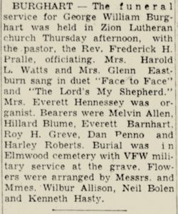
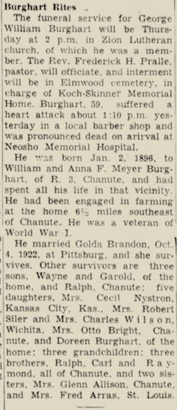
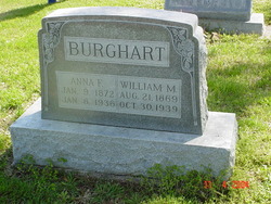
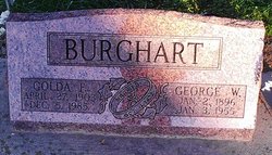
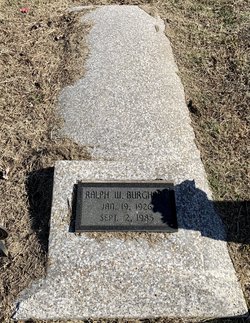
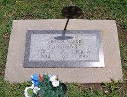
George William Burghart
| Birth | : | 2 Jan 1896 Chanute, Neosho County, Kansas, USA |
| Death | : | 3 Jan 1955 Chanute, Neosho County, Kansas, USA |
| Burial | : | Moores Corner Cemetery, Leverett, Franklin County, USA |
| Coordinate | : | 42.4924200, -72.4730700 |
| Plot | : | Section 105 Block 03 Lot 041 Space 05 |
| Description | : | Kansas Pfc Co C 339 Mg Bn 88 Div World War 1 |
frequently asked questions (FAQ):
-
Where is George William Burghart's memorial?
George William Burghart's memorial is located at: Moores Corner Cemetery, Leverett, Franklin County, USA.
-
When did George William Burghart death?
George William Burghart death on 3 Jan 1955 in Chanute, Neosho County, Kansas, USA
-
Where are the coordinates of the George William Burghart's memorial?
Latitude: 42.4924200
Longitude: -72.4730700
Family Members:
Parent

Spouse
Siblings
Children

Flowers:


Nearby Cemetories:
1. Moores Corner Cemetery
Leverett, Franklin County, USA
Coordinate: 42.4924200, -72.4730700
2. Plain View Cemetery
Leverett, Franklin County, USA
Coordinate: 42.4972100, -72.4751900
3. Patrick Cemetery
Leverett, Franklin County, USA
Coordinate: 42.4995800, -72.4619500
4. Gardner Cemetery
Leverett, Franklin County, USA
Coordinate: 42.5036011, -72.4574966
5. Mount Hope Cemetery
Leverett, Franklin County, USA
Coordinate: 42.5111008, -72.4906006
6. Jackson Hill Cemetery
Leverett, Franklin County, USA
Coordinate: 42.5028000, -72.5028000
7. Marvell Cemetery
Leverett, Franklin County, USA
Coordinate: 42.5028000, -72.5042038
8. Locks Village Cemetery
Shutesbury, Franklin County, USA
Coordinate: 42.5010200, -72.4364000
9. Chestnut Hill Cemetery
Montague, Franklin County, USA
Coordinate: 42.5228004, -72.4822006
10. North Cemetery
Leverett, Franklin County, USA
Coordinate: 42.4673720, -72.4983230
11. Mount Toby Cemetery
Leverett, Franklin County, USA
Coordinate: 42.4894810, -72.5174400
12. South Cemetery
Wendell, Franklin County, USA
Coordinate: 42.5092000, -72.4206000
13. Jewish Community Association of Amherst Cemetery
Shutesbury, Franklin County, USA
Coordinate: 42.4502690, -72.4297230
14. Luther Henry Tomb Yard
Shutesbury, Franklin County, USA
Coordinate: 42.4501500, -72.4253400
15. West Cemetery
Shutesbury, Franklin County, USA
Coordinate: 42.4502300, -72.4242700
16. Old South Cemetery
Montague, Franklin County, USA
Coordinate: 42.5232500, -72.5360300
17. North Sunderland Cemetery
Sunderland, Franklin County, USA
Coordinate: 42.4972000, -72.5492020
18. Long Plain Cemetery
Leverett, Franklin County, USA
Coordinate: 42.4510994, -72.5250015
19. East Leverett Cemetery
Leverett, Franklin County, USA
Coordinate: 42.4357224, -72.4857788
20. Dry Hill Cemetery
Montague, Franklin County, USA
Coordinate: 42.5558300, -72.4647600
21. Locust Hill Cemetery
Montague, Franklin County, USA
Coordinate: 42.5394700, -72.5363400
22. Elm Grove Cemetery
Montague, Franklin County, USA
Coordinate: 42.5418600, -72.5359000
23. Pine Nook Cemetery
Deerfield, Franklin County, USA
Coordinate: 42.5086300, -72.5661400
24. Town Cemetery
Montague, Franklin County, USA
Coordinate: 42.5595000, -72.5070200