
| Memorials | : | 0 |
| Location | : | Montague, Franklin County, USA |
| Coordinate | : | 42.5595000, -72.5070200 |
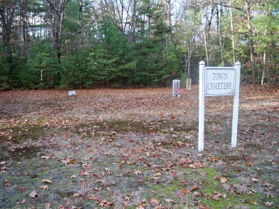
| Description | : | This is a town-owned cemetery. It is unknown when it was established. There are only 3 remaining headstones. The Town of Montague refers to this cemetery in MassGIS as Parcel ID: 34-058. The Massachusetts Historical Commission does not refer to this cemetery in MACRIS. This burial place is referenced to in the book "Vital Records of Montague, Massachusetts to the end of the year 1849" as G.R.2. |
frequently asked questions (FAQ):
-
Where is Town Cemetery?
Town Cemetery is located at Federal Street (Route 63) Montague, Franklin County ,Massachusetts , 01376USA.
-
Town Cemetery cemetery's updated grave count on graveviews.com?
0 memorials
-
Where are the coordinates of the Town Cemetery?
Latitude: 42.5595000
Longitude: -72.5070200
Nearby Cemetories:
1. Highland Cemetery
Montague, Franklin County, USA
Coordinate: 42.5778008, -72.5083008
2. East Mineral Road Cemetery
Montague, Franklin County, USA
Coordinate: 42.5810500, -72.5086300
3. Elm Grove Cemetery
Montague, Franklin County, USA
Coordinate: 42.5418600, -72.5359000
4. Locust Hill Cemetery
Montague, Franklin County, USA
Coordinate: 42.5394700, -72.5363400
5. Dry Hill Cemetery
Montague, Franklin County, USA
Coordinate: 42.5558300, -72.4647600
6. Holton Cemetery
Erving, Franklin County, USA
Coordinate: 42.5799500, -72.4634600
7. Aaron Clark Memorial Cemetery
Montague, Franklin County, USA
Coordinate: 42.5836200, -72.5471600
8. Our Lady of Czestochowa Cemetery
Montague, Franklin County, USA
Coordinate: 42.5846000, -72.5469400
9. Saint Marys Cemetery
Montague, Franklin County, USA
Coordinate: 42.5852200, -72.5475100
10. Saint Annes Cemetery
Montague, Franklin County, USA
Coordinate: 42.5861300, -72.5480600
11. Chestnut Hill Cemetery
Montague, Franklin County, USA
Coordinate: 42.5228004, -72.4822006
12. Old South Cemetery
Montague, Franklin County, USA
Coordinate: 42.5232500, -72.5360300
13. East Deerfield Cemetery
Deerfield, Franklin County, USA
Coordinate: 42.5555992, -72.5642014
14. Diemand Family Cemetery
Wendell, Franklin County, USA
Coordinate: 42.5769900, -72.4520600
15. Springdale Cemetery
Montague, Franklin County, USA
Coordinate: 42.5884700, -72.5530900
16. Mount Hope Cemetery
Leverett, Franklin County, USA
Coordinate: 42.5111008, -72.4906006
17. Durkee Burial Lot
Northfield, Franklin County, USA
Coordinate: 42.6070000, -72.4861000
18. Fairway Avenue Cemetery
Montague, Franklin County, USA
Coordinate: 42.5924270, -72.5646970
19. Burnham Cemetery
Montague, Franklin County, USA
Coordinate: 42.5875300, -72.5720140
20. Marvell Cemetery
Leverett, Franklin County, USA
Coordinate: 42.5028000, -72.5042038
21. Jackson Hill Cemetery
Leverett, Franklin County, USA
Coordinate: 42.5028000, -72.5028000
22. Northfield Farms Cemetery
Northfield, Franklin County, USA
Coordinate: 42.6124992, -72.4741974
23. Riverside Cemetery
Gill, Franklin County, USA
Coordinate: 42.6156006, -72.5410995
24. Plain View Cemetery
Leverett, Franklin County, USA
Coordinate: 42.4972100, -72.4751900