
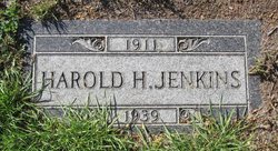
Harold Herbert Jenkins
| Birth | : | 23 Feb 1911 Winnebago, Faribault County, Minnesota, USA |
| Death | : | 9 Feb 1939 Big Sandy, Chouteau County, Montana, USA |
| Burial | : | St. Peter and St. Paul Churchyard, Shiplake, South Oxfordshire District, England |
| Coordinate | : | 51.4980750, -0.8963940 |
| Description | : | The following provided by Find A Grave contributor "Cara": Great Falls Tribune (MT), 13 Feb 1939 Harold H. Jenkins, 27, Dies At Big Sandy Havre, Feb 12--Harold H. Jenkins, 27, of Big Sandy, who died here of sleeping sickness, was buried Saturday at Big Sandy. The Rev. John Morange of the Van Orsdel Methodist church officiated. Jenkins was graduated from Big Sandy high school in 1933 and afterwards engaged in the trucking business. Surviving him are his widow and son, Jerry, 2-1/2 years old; his parents, Mr. and Mrs. Walter Jenkins of Big Sandy; and four brothers, John, Lawrence, Richard of Big... Read More |
frequently asked questions (FAQ):
-
Where is Harold Herbert Jenkins's memorial?
Harold Herbert Jenkins's memorial is located at: St. Peter and St. Paul Churchyard, Shiplake, South Oxfordshire District, England.
-
When did Harold Herbert Jenkins death?
Harold Herbert Jenkins death on 9 Feb 1939 in Big Sandy, Chouteau County, Montana, USA
-
Where are the coordinates of the Harold Herbert Jenkins's memorial?
Latitude: 51.4980750
Longitude: -0.8963940
Family Members:
Parent
Spouse
Siblings

Flowers:


Nearby Cemetories:
1. St. Peter and St. Paul Churchyard
Shiplake, South Oxfordshire District, England
Coordinate: 51.4980750, -0.8963940
2. St. Mary's Churchyard
Wargrave, Wokingham Borough, England
Coordinate: 51.4998329, -0.8735808
3. St Margaret's Churchyard
Harpsden, South Oxfordshire District, England
Coordinate: 51.5219160, -0.9012270
4. St. Andrew's Churchyard
Sonning, Wokingham Borough, England
Coordinate: 51.4740300, -0.9131640
5. St Mary's Churchyard
Twyford, Wokingham Borough, England
Coordinate: 51.4763850, -0.8673190
6. All Saints Churchyard
Dunsden Green, South Oxfordshire District, England
Coordinate: 51.4917730, -0.9461650
7. Holy Trinity Churchyard
Henley-on-Thames, South Oxfordshire District, England
Coordinate: 51.5338500, -0.9066600
8. Christ Church
Henley-on-Thames, South Oxfordshire District, England
Coordinate: 51.5347880, -0.9032820
9. St. Mary the Virgin Churchyard
Henley-on-Thames, South Oxfordshire District, England
Coordinate: 51.5377790, -0.9017520
10. Reading Cemetery and Crematorium
Caversham, Reading Borough, England
Coordinate: 51.4737690, -0.9546570
11. St. Nicholas' Churchyard
Rotherfield Greys, South Oxfordshire District, England
Coordinate: 51.5351017, -0.9541395
12. St. Peter's Churchyard
Knowl Hill, Windsor and Maidenhead Royal Borough, England
Coordinate: 51.5093351, -0.8126725
13. Caversham Cemetery
Caversham, Reading Borough, England
Coordinate: 51.4745850, -0.9758020
14. Reading Cemetery
Reading, Reading Borough, England
Coordinate: 51.4529450, -0.9480160
15. All Saints Churchyard
Rotherfield Peppard, South Oxfordshire District, England
Coordinate: 51.5280531, -0.9725009
16. St Lawrence Churchyard
Waltham St Lawrence, Windsor and Maidenhead Royal Borough, England
Coordinate: 51.4856000, -0.8066600
17. Mays Lane Burial Ground
Earley, Wokingham Borough, England
Coordinate: 51.4431680, -0.9240020
18. Earley St Peter Churchyard
Earley, Wokingham Borough, England
Coordinate: 51.4434820, -0.9290850
19. Reading Prison Cemetery
Reading, Reading Borough, England
Coordinate: 51.4564910, -0.9641120
20. Henley-on-Thames Cemetery
Henley-on-Thames, South Oxfordshire District, England
Coordinate: 51.5543570, -0.9271320
21. Reading Abbey Ruins
Reading, Reading Borough, England
Coordinate: 51.4563710, -0.9651130
22. St. Peter's Churchyard
Caversham, Reading Borough, England
Coordinate: 51.4686597, -0.9807669
23. St. Laurence Churchyard
Reading, Reading Borough, England
Coordinate: 51.4567474, -0.9686236
24. Kidmore End Cemetery
Kidmore End, South Oxfordshire District, England
Coordinate: 51.5071600, -0.9942160