
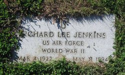
Richard Lee Jenkins
| Birth | : | 4 Mar 1922 |
| Death | : | 31 May 1994 Sheridan, Sheridan County, Wyoming, USA |
| Burial | : | St. Peter and St. Paul Churchyard, Shiplake, South Oxfordshire District, England |
| Coordinate | : | 51.4980750, -0.8963940 |
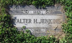
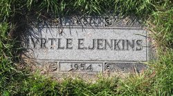
| Description | : | Obituary from Find A Grave contributor "Cara": The Mountaineer, Big Sandy, MT, 15 Jun 1994 (excerpt) Richard Lee Jenkins, a former Big Sandy resident, died Tuesday, May 21, 1994, in a Sheridan, WY, veterans hospital, of natural causes. Jenkins was born March 4, 1922, son of Walter and Myrtle Jenkins. He was raised in Big Sandy and graduated from Big Sandy High School. His most memorable moment he loved to share was as a trumpeter in the high school band, when he played for the Queen of England during a Canadian visit. Jenkins attended Northern Montana... Read More |
frequently asked questions (FAQ):
-
Where is Richard Lee Jenkins's memorial?
Richard Lee Jenkins's memorial is located at: St. Peter and St. Paul Churchyard, Shiplake, South Oxfordshire District, England.
-
When did Richard Lee Jenkins death?
Richard Lee Jenkins death on 31 May 1994 in Sheridan, Sheridan County, Wyoming, USA
-
Where are the coordinates of the Richard Lee Jenkins's memorial?
Latitude: 51.4980750
Longitude: -0.8963940
Family Members:
Parent
Siblings

Flowers:


Nearby Cemetories:
1. St. Peter and St. Paul Churchyard
Shiplake, South Oxfordshire District, England
Coordinate: 51.4980750, -0.8963940
2. St. Mary's Churchyard
Wargrave, Wokingham Borough, England
Coordinate: 51.4998329, -0.8735808
3. St Margaret's Churchyard
Harpsden, South Oxfordshire District, England
Coordinate: 51.5219160, -0.9012270
4. St. Andrew's Churchyard
Sonning, Wokingham Borough, England
Coordinate: 51.4740300, -0.9131640
5. St Mary's Churchyard
Twyford, Wokingham Borough, England
Coordinate: 51.4763850, -0.8673190
6. All Saints Churchyard
Dunsden Green, South Oxfordshire District, England
Coordinate: 51.4917730, -0.9461650
7. Holy Trinity Churchyard
Henley-on-Thames, South Oxfordshire District, England
Coordinate: 51.5338500, -0.9066600
8. Christ Church
Henley-on-Thames, South Oxfordshire District, England
Coordinate: 51.5347880, -0.9032820
9. St. Mary the Virgin Churchyard
Henley-on-Thames, South Oxfordshire District, England
Coordinate: 51.5377790, -0.9017520
10. Reading Cemetery and Crematorium
Caversham, Reading Borough, England
Coordinate: 51.4737690, -0.9546570
11. St. Nicholas' Churchyard
Rotherfield Greys, South Oxfordshire District, England
Coordinate: 51.5351017, -0.9541395
12. St. Peter's Churchyard
Knowl Hill, Windsor and Maidenhead Royal Borough, England
Coordinate: 51.5093351, -0.8126725
13. Caversham Cemetery
Caversham, Reading Borough, England
Coordinate: 51.4745850, -0.9758020
14. Reading Cemetery
Reading, Reading Borough, England
Coordinate: 51.4529450, -0.9480160
15. All Saints Churchyard
Rotherfield Peppard, South Oxfordshire District, England
Coordinate: 51.5280531, -0.9725009
16. St Lawrence Churchyard
Waltham St Lawrence, Windsor and Maidenhead Royal Borough, England
Coordinate: 51.4856000, -0.8066600
17. Mays Lane Burial Ground
Earley, Wokingham Borough, England
Coordinate: 51.4431680, -0.9240020
18. Earley St Peter Churchyard
Earley, Wokingham Borough, England
Coordinate: 51.4434820, -0.9290850
19. Reading Prison Cemetery
Reading, Reading Borough, England
Coordinate: 51.4564910, -0.9641120
20. Henley-on-Thames Cemetery
Henley-on-Thames, South Oxfordshire District, England
Coordinate: 51.5543570, -0.9271320
21. Reading Abbey Ruins
Reading, Reading Borough, England
Coordinate: 51.4563710, -0.9651130
22. St. Peter's Churchyard
Caversham, Reading Borough, England
Coordinate: 51.4686597, -0.9807669
23. St. Laurence Churchyard
Reading, Reading Borough, England
Coordinate: 51.4567474, -0.9686236
24. Kidmore End Cemetery
Kidmore End, South Oxfordshire District, England
Coordinate: 51.5071600, -0.9942160