
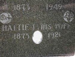


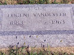
Harriet L “Hattie” Vandeveer Hosley
| Birth | : | 1875 |
| Death | : | 1921 |
| Burial | : | St Mary Magdalene Churchyard, Essendine, Rutland Unitary Authority, England |
| Coordinate | : | 52.7026000, -0.4489000 |
| Plot | : | Block 1, Row 6 |
frequently asked questions (FAQ):
-
Where is Harriet L “Hattie” Vandeveer Hosley's memorial?
Harriet L “Hattie” Vandeveer Hosley's memorial is located at: St Mary Magdalene Churchyard, Essendine, Rutland Unitary Authority, England.
-
When did Harriet L “Hattie” Vandeveer Hosley death?
Harriet L “Hattie” Vandeveer Hosley death on 1921 in
-
Where are the coordinates of the Harriet L “Hattie” Vandeveer Hosley's memorial?
Latitude: 52.7026000
Longitude: -0.4489000
Family Members:
Parent

Spouse
Siblings
Children

Flowers:


Nearby Cemetories:
1. St Mary Magdalene Churchyard
Essendine, Rutland Unitary Authority, England
Coordinate: 52.7026000, -0.4489000
2. Saint Stephen
Carlby, South Kesteven District, England
Coordinate: 52.7125650, -0.4475800
3. St John the Evangelist Churchyard
Ryhall, Rutland Unitary Authority, England
Coordinate: 52.6852000, -0.4685000
4. Ryhall Churchyard Extension
Ryhall, Rutland Unitary Authority, England
Coordinate: 52.6849000, -0.4678700
5. St. Andrews Churchyard
Witham on the Hill, South Kesteven District, England
Coordinate: 52.7364500, -0.4420300
6. All Saints Churchyard
Little Casterton, Rutland Unitary Authority, England
Coordinate: 52.6775807, -0.4965072
7. St Stephen Churchyard
Careby, South Kesteven District, England
Coordinate: 52.7363500, -0.4823700
8. St Faith Churchyard
Wilsthorpe, South Kesteven District, England
Coordinate: 52.7095208, -0.3848166
9. St Martin Churchyard
Barholm, South Kesteven District, England
Coordinate: 52.6855000, -0.3887600
10. Newstead Priory
Stamford, South Kesteven District, England
Coordinate: 52.6582800, -0.4542480
11. St Michael & All Angels Churchyard
Uffington, South Kesteven District, England
Coordinate: 52.6570400, -0.4321700
12. Greyfriars
Stamford, South Kesteven District, England
Coordinate: 52.6547990, -0.4697460
13. St Wilfrid
Holywell, South Kesteven District, England
Coordinate: 52.7329915, -0.5149881
14. Stamford Cemetery
Stamford, South Kesteven District, England
Coordinate: 52.6564300, -0.4905600
15. St. Michael's Churchyard
Stamford, South Kesteven District, England
Coordinate: 52.6524606, -0.4774019
16. All Saints Church
Stamford, South Kesteven District, England
Coordinate: 52.6522610, -0.4808400
17. St Mary's Churchyard
Stamford, South Kesteven District, England
Coordinate: 52.6514440, -0.4783930
18. St. George's Churchyard
Stamford, South Kesteven District, England
Coordinate: 52.6514110, -0.4782500
19. Saint John the Baptist Church
Stamford, South Kesteven District, England
Coordinate: 52.6517890, -0.4801320
20. St Peter & St Paul Churchyard
Great Casterton, Rutland Unitary Authority, England
Coordinate: 52.6676700, -0.5203600
21. St. Martin's Churchyard
Stamford, South Kesteven District, England
Coordinate: 52.6490200, -0.4773670
22. St. Lawrence's Churchyard
Tallington, South Kesteven District, England
Coordinate: 52.6574520, -0.3879120
23. Baston Cemetery
Baston, South Kesteven District, England
Coordinate: 52.7149917, -0.3531338
24. St John the Baptist Churchyard
Baston, South Kesteven District, England
Coordinate: 52.7149530, -0.3530650