
| Memorials | : | 2 |
| Location | : | Holywell, South Kesteven District, England |
| Coordinate | : | 52.7329915, -0.5149881 |
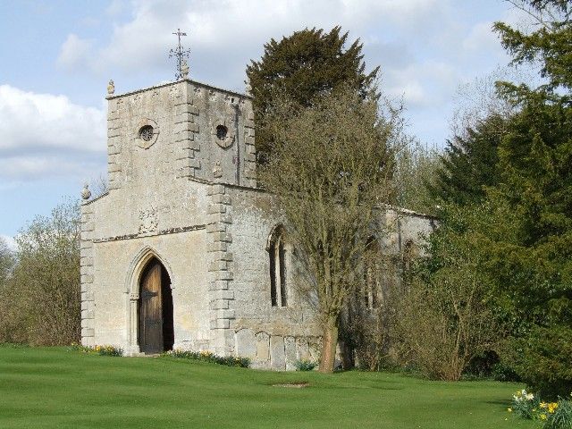
| Description | : | Holywell is a chapelry of Careby parish. The church in Holywell Hall grounds was moved in 1699 from a site east of the Castle Bytham road 'between the bridge and the mill' where it had been subject to frequent flooding. It incorporates material from the destroyed church of Aunby, including two Norman piers that support the tower, a Decorated doorway and a window glazed with Perpendicular style glass. Pevsner adds that St Wilfrid's church stands south of Holywell Hall as one of its garden ornaments, has an east window with a mosaic of small fragments from the 15th to 19th... Read More |
frequently asked questions (FAQ):
-
Where is St Wilfrid?
St Wilfrid is located at Holywell, South Kesteven District ,Lincolnshire ,England.
-
St Wilfrid cemetery's updated grave count on graveviews.com?
2 memorials
-
Where are the coordinates of the St Wilfrid?
Latitude: 52.7329915
Longitude: -0.5149881
Nearby Cemetories:
1. St Stephen Churchyard
Careby, South Kesteven District, England
Coordinate: 52.7363500, -0.4823700
2. St James Churchyard
Castle Bytham, South Kesteven District, England
Coordinate: 52.7537140, -0.5367360
3. St Peter Churchyard
Creeton, South Kesteven District, England
Coordinate: 52.7669500, -0.4977300
4. St. Andrews Churchyard
Witham on the Hill, South Kesteven District, England
Coordinate: 52.7364500, -0.4420300
5. Saint Stephen
Carlby, South Kesteven District, England
Coordinate: 52.7125650, -0.4475800
6. St Mary Magdalene Churchyard
Essendine, Rutland Unitary Authority, England
Coordinate: 52.7026000, -0.4489000
7. St John the Evangelist Churchyard
Ryhall, Rutland Unitary Authority, England
Coordinate: 52.6852000, -0.4685000
8. Ryhall Churchyard Extension
Ryhall, Rutland Unitary Authority, England
Coordinate: 52.6849000, -0.4678700
9. All Saints Churchyard
Little Casterton, Rutland Unitary Authority, England
Coordinate: 52.6775807, -0.4965072
10. St Mary Churchyard
Swinstead, South Kesteven District, England
Coordinate: 52.7900380, -0.4909380
11. St Nicholas Churchyard
Swayfield, South Kesteven District, England
Coordinate: 52.7922400, -0.5284400
12. St Peter's Churchyard
Tickencote, Rutland Unitary Authority, England
Coordinate: 52.6741278, -0.5365826
13. St Peter & St Paul Churchyard
Great Casterton, Rutland Unitary Authority, England
Coordinate: 52.6676700, -0.5203600
14. St Mary the Virgin Churchyard
Greetham, Rutland Unitary Authority, England
Coordinate: 52.7216100, -0.6325650
15. St Michael Churchyard
Edenham, South Kesteven District, England
Coordinate: 52.7836110, -0.4266560
16. Stamford Cemetery
Stamford, South Kesteven District, England
Coordinate: 52.6564300, -0.4905600
17. St John the Evangelist Churchyard
Corby Glen, South Kesteven District, England
Coordinate: 52.8132500, -0.5157630
18. St Faith Churchyard
Wilsthorpe, South Kesteven District, England
Coordinate: 52.7095208, -0.3848166
19. St Nicholas Churchyard
Thistleton, Rutland Unitary Authority, England
Coordinate: 52.7516900, -0.6483100
20. Greyfriars
Stamford, South Kesteven District, England
Coordinate: 52.6547990, -0.4697460
21. St Peter Churchyard
Empingham, Rutland Unitary Authority, England
Coordinate: 52.6656310, -0.5957880
22. Newstead Priory
Stamford, South Kesteven District, England
Coordinate: 52.6582800, -0.4542480
23. All Saints Church
Stamford, South Kesteven District, England
Coordinate: 52.6522610, -0.4808400
24. St. Michael's Churchyard
Stamford, South Kesteven District, England
Coordinate: 52.6524606, -0.4774019