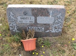
Harvey Eugene Bolling
| Birth | : | 1 Oct 1927 Forsyth, Taney County, Missouri, USA |
| Death | : | 2 Jun 1984 Port Townsend, Jefferson County, Washington, USA |
| Burial | : | York Minster, York, York Unitary Authority, England |
| Coordinate | : | 53.9619440, -1.0819440 |
| Description | : | Port Angeles Public Library Publication: Daily News Date of Article: 6/4/1984 Title: Bolling, Harvey Eugene Author: Bolling, Harvey Eugene, Abstract: 1 Oct 1927 - 2 Jun 1984 Notes: Section: Page_Number: A3 PageColumn: 1 Bolling Harvey Eugene 6/1/1984 6/6/1984 Obit B-51 obit - Jefferson Co., Hist. Soc. Social Security Death Index about Harvey Bolling Name: Harvey Bolling SSN:... Read More |
frequently asked questions (FAQ):
-
Where is Harvey Eugene Bolling's memorial?
Harvey Eugene Bolling's memorial is located at: York Minster, York, York Unitary Authority, England.
-
When did Harvey Eugene Bolling death?
Harvey Eugene Bolling death on 2 Jun 1984 in Port Townsend, Jefferson County, Washington, USA
-
Where are the coordinates of the Harvey Eugene Bolling's memorial?
Latitude: 53.9619440
Longitude: -1.0819440
Family Members:
Parent
Siblings
Flowers:
Nearby Cemetories:
1. York Minster
York, York Unitary Authority, England
Coordinate: 53.9619440, -1.0819440
2. St Michael le Belfrey Churchyard
York, York Unitary Authority, England
Coordinate: 53.9618620, -1.0829730
3. Holy Trinity Goodramgate Churchyard
York, York Unitary Authority, England
Coordinate: 53.9609810, -1.0804640
4. St Wilfred Churchyard
York, York Unitary Authority, England
Coordinate: 53.9610550, -1.0848990
5. St Helen Churchyard
York, York Unitary Authority, England
Coordinate: 53.9603030, -1.0841970
6. St Sampson Churchyard
York, York Unitary Authority, England
Coordinate: 53.9597440, -1.0813060
7. Holy Trinity Kings Court Churchyard
York, York Unitary Authority, England
Coordinate: 53.9599760, -1.0800800
8. St Andrew Churchyard
York, York Unitary Authority, England
Coordinate: 53.9609180, -1.0784710
9. St Helen Davygate Church Cemetery
York, York Unitary Authority, England
Coordinate: 53.9596460, -1.0830390
10. St Giles Churchyard
York, York Unitary Authority, England
Coordinate: 53.9640010, -1.0843930
11. St Maurice Churchyard
York, York Unitary Authority, England
Coordinate: 53.9633340, -1.0782010
12. Lendal Congregational Chapel
York, York Unitary Authority, England
Coordinate: 53.9606360, -1.0860970
13. St Martin le Grand Churchyard
York, York Unitary Authority, England
Coordinate: 53.9593870, -1.0843800
14. Augustinian Friary, York (Nonextant)
York, York Unitary Authority, England
Coordinate: 53.9601683, -1.0860521
15. York Unitarian Chapelyard
York, York Unitary Authority, England
Coordinate: 53.9602950, -1.0775710
16. Central Methodist Hall
York, York Unitary Authority, England
Coordinate: 53.9594090, -1.0788330
17. St Crux Churchyard
York, York Unitary Authority, England
Coordinate: 53.9589890, -1.0795460
18. St Saviour Churchyard
York, York Unitary Authority, England
Coordinate: 53.9596100, -1.0780000
19. St Peter the Little (Defunct)
York, York Unitary Authority, England
Coordinate: 53.9585310, -1.0821170
20. St Crux Hungate Burial Ground
York, York Unitary Authority, England
Coordinate: 53.9593540, -1.0774470
21. Abbey of St Mary (defunct)
York, York Unitary Authority, England
Coordinate: 53.9620290, -1.0883600
22. All Saints Pavement Churchyard
York, York Unitary Authority, England
Coordinate: 53.9581090, -1.0808820
23. St Cuthbert Churchyard
York, York Unitary Authority, England
Coordinate: 53.9609180, -1.0752310
24. St Michael Churchyard
York, York Unitary Authority, England
Coordinate: 53.9577900, -1.0825600


