
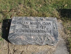
Helen Marie Goin
| Birth | : | 12 Sep 1915 Liberty, Gage County, Nebraska, USA |
| Death | : | 22 Apr 1935 Liberty, Gage County, Nebraska, USA |
| Burial | : | Old New Garden Primitive Baptist Cemetery, Wood Heights, Ray County, USA |
| Coordinate | : | 39.3227005, -94.1669006 |
frequently asked questions (FAQ):
-
Where is Helen Marie Goin's memorial?
Helen Marie Goin's memorial is located at: Old New Garden Primitive Baptist Cemetery, Wood Heights, Ray County, USA.
-
When did Helen Marie Goin death?
Helen Marie Goin death on 22 Apr 1935 in Liberty, Gage County, Nebraska, USA
-
Where are the coordinates of the Helen Marie Goin's memorial?
Latitude: 39.3227005
Longitude: -94.1669006
Family Members:
Parent

Siblings
Flowers:


Nearby Cemetories:
1. Old New Garden Primitive Baptist Cemetery
Wood Heights, Ray County, USA
Coordinate: 39.3227005, -94.1669006
2. North New Garden Primitive Baptist Church Cemetery
Wood Heights, Ray County, USA
Coordinate: 39.3271027, -94.1648026
3. Pisgah Cemetery
Wood Heights, Ray County, USA
Coordinate: 39.3376846, -94.1775055
4. Cox Cemetery
Wood Heights, Ray County, USA
Coordinate: 39.3368988, -94.1819000
5. Windy Hill Cemetery
Wood Heights, Ray County, USA
Coordinate: 39.3407364, -94.1462250
6. John Cleavenger Cemetery
Crystal Lakes, Ray County, USA
Coordinate: 39.3551407, -94.1542053
7. John Clevenger Cemetery
Crystal Lakes, Ray County, USA
Coordinate: 39.3551300, -94.1540600
8. O'Dell Cemetery
Excelsior Springs, Ray County, USA
Coordinate: 39.2995987, -94.1346970
9. Hamers Farm Cemetery
Ray County, USA
Coordinate: 39.3560400, -94.1762900
10. Siegel Cemetery
Excelsior Springs, Ray County, USA
Coordinate: 39.2943993, -94.1977997
11. Clevenger Cemetery
Crystal Lakes, Ray County, USA
Coordinate: 39.3600006, -94.1560974
12. Cravens Headstone
Ray County, USA
Coordinate: 39.3134300, -94.1080300
13. Rock Falls Church Cemetery
Elkhorn, Ray County, USA
Coordinate: 39.2893500, -94.1221800
14. Enon Cemetery
Excelsior Springs, Clay County, USA
Coordinate: 39.2958984, -94.2221985
15. Hamilton Cemetery
Ray County, USA
Coordinate: 39.3107986, -94.1007996
16. Rowland Cemetery
Ray County, USA
Coordinate: 39.2694016, -94.1389008
17. Crowley Cemetery
Vibbard, Ray County, USA
Coordinate: 39.3807793, -94.1616745
18. Bogart Family Cemetery
Ray County, USA
Coordinate: 39.2644400, -94.1777800
19. Pettus Cemetery
Elkhorn, Ray County, USA
Coordinate: 39.2935982, -94.0988998
20. Elmwood Cemetery
Excelsior Springs, Clay County, USA
Coordinate: 39.3353004, -94.2485962
21. Salem Christian Union Church Cemetery
Excelsior Springs, Clay County, USA
Coordinate: 39.3766708, -94.2157745
22. Crown Hill Cemetery
Excelsior Springs, Clay County, USA
Coordinate: 39.3446999, -94.2474976
23. Masonic Cemetery
Excelsior Springs, Clay County, USA
Coordinate: 39.3432655, -94.2482910
24. Gant Cemetery
Rayville, Ray County, USA
Coordinate: 39.3548393, -94.0880280