
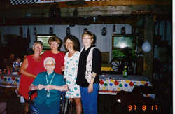


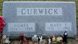
Hilda Sophia Onken Curwick
| Birth | : | 27 Aug 1903 Francesville, Pulaski County, Indiana, USA |
| Death | : | 18 Apr 1999 Monticello, White County, Indiana, USA |
| Burial | : | Saint Anne's Church, Woodplumpton, City of Preston, England |
| Coordinate | : | 53.8038130, -2.7621940 |
frequently asked questions (FAQ):
-
Where is Hilda Sophia Onken Curwick's memorial?
Hilda Sophia Onken Curwick's memorial is located at: Saint Anne's Church, Woodplumpton, City of Preston, England.
-
When did Hilda Sophia Onken Curwick death?
Hilda Sophia Onken Curwick death on 18 Apr 1999 in Monticello, White County, Indiana, USA
-
Where are the coordinates of the Hilda Sophia Onken Curwick's memorial?
Latitude: 53.8038130
Longitude: -2.7621940
Family Members:
Parent

Spouse
Siblings


Children
Flowers:


Nearby Cemetories:
1. Saint Anne's Church
Woodplumpton, City of Preston, England
Coordinate: 53.8038130, -2.7621940
2. St Andrew George Haydock Roman Catholic Churchyard
Cottam, City of Preston, England
Coordinate: 53.7879280, -2.7591570
3. St Mary's Newhouse
Barton, City of Preston, England
Coordinate: 53.8205240, -2.7406500
4. St. John Baptist Churchyard
Broughton-in-Amounderness, City of Preston, England
Coordinate: 53.8033700, -2.7170400
5. St. Lawrence Churchyard
Barton, City of Preston, England
Coordinate: 53.8289213, -2.7366654
6. St. Mary's Churchyard
Lea, City of Preston, England
Coordinate: 53.7733810, -2.7942770
7. St. Andrew's Churchyard
Ashton-on-Ribble, City of Preston, England
Coordinate: 53.7687030, -2.7359180
8. St. John the Evangelist Churchyard
Clifton, Fylde Borough, England
Coordinate: 53.7758600, -2.8158500
9. Christ Church Churchyard
Fulwood, City of Preston, England
Coordinate: 53.7771920, -2.7028700
10. St. Peters Churchyard
Inskip with Sowerby, Wyre Borough, England
Coordinate: 53.8347100, -2.8175200
11. Christ Churchyard
Treales, Fylde Borough, England
Coordinate: 53.8045970, -2.8440710
12. St Walburge's RC Church
Preston, City of Preston, England
Coordinate: 53.7629690, -2.7149620
13. St. Mary's Churchyard
Preston, City of Preston, England
Coordinate: 53.8010830, -2.6779600
14. St. Hilda's Churchyard
Bilsborrow, Wyre Borough, England
Coordinate: 53.8522170, -2.7420090
15. Inskip Baptist Churchyard
Inskip with Sowerby, Wyre Borough, England
Coordinate: 53.8353150, -2.8299610
16. Saint Peter Churchyard
Preston, City of Preston, England
Coordinate: 53.7634100, -2.7080700
17. St Mary Churchyard
Penwortham, South Ribble Borough, England
Coordinate: 53.7551800, -2.7234210
18. Grey Friars' Church
Preston, City of Preston, England
Coordinate: 53.7601480, -2.7084600
19. Holy Trinity
Preston, City of Preston, England
Coordinate: 53.7613030, -2.7030580
20. Friends Meeting House Burial Ground (Defunct)
Preston, City of Preston, England
Coordinate: 53.7610250, -2.7030380
21. Christ Church Churchyard
Preston, City of Preston, England
Coordinate: 53.7573210, -2.7103080
22. St. Ignatius RC Churchyard
Preston, City of Preston, England
Coordinate: 53.7635270, -2.6965870
23. St. George the Martyr
Preston, City of Preston, England
Coordinate: 53.7591220, -2.7025660
24. St. Wilfrid's Catholic Cemetery
Preston, City of Preston, England
Coordinate: 53.7581670, -2.7044930