
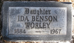
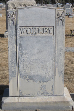
Ida Benson Worley
| Birth | : | 15 Sep 1884 Litchfield, Sherman County, Nebraska, USA |
| Death | : | 8 Jun 1967 Alliance, Box Butte County, Nebraska, USA |
| Burial | : | Maple Hill Cemetery, Stoutsville, Fairfield County, USA |
| Coordinate | : | 39.6006012, -82.8227997 |
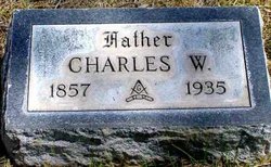
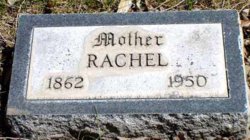
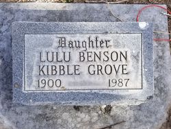
| Description | : | Ida is the Second wife of Lewis Nelson Worley marrying on December 1, 1922 in Box Butte County, NE. She is the daughter of Charles and Rachel (Wilson) Benson. Mrs. Ida Worley, 82, died unexpectedly late Thursday night at her home, 520 Missouri. Her death apparently followed a heart attack. Mrs. Worley, who used a wheel chair because of arthritis, had been dead a short time when her sister, Mrs. Lulu Grove, found her. Mrs. Worley was born September 15, 1884 in Litchfield and was married to the late Nels Worley. She was a member of the... Read More |
frequently asked questions (FAQ):
-
Where is Ida Benson Worley's memorial?
Ida Benson Worley's memorial is located at: Maple Hill Cemetery, Stoutsville, Fairfield County, USA.
-
When did Ida Benson Worley death?
Ida Benson Worley death on 8 Jun 1967 in Alliance, Box Butte County, Nebraska, USA
-
Where are the coordinates of the Ida Benson Worley's memorial?
Latitude: 39.6006012
Longitude: -82.8227997
Family Members:
Parent
Spouse
Siblings
Children
Flowers:


Nearby Cemetories:
1. Maple Hill Cemetery
Stoutsville, Fairfield County, USA
Coordinate: 39.6006012, -82.8227997
2. Heidelberg Reformed Church Cemetery
Stoutsville, Fairfield County, USA
Coordinate: 39.6047783, -82.8269348
3. Wolf Cemetery
Stoutsville, Fairfield County, USA
Coordinate: 39.5901600, -82.8070200
4. Bunker Hill Cemetery
Stoutsville, Fairfield County, USA
Coordinate: 39.5855100, -82.8308600
5. Neff Cemetery
Stoutsville, Fairfield County, USA
Coordinate: 39.5821991, -82.8106003
6. Stout Family Cemetery
Washington Township, Pickaway County, USA
Coordinate: 39.6241989, -82.8439026
7. Spengler Cemetery
Stoutsville, Fairfield County, USA
Coordinate: 39.5653290, -82.8241650
8. Zion Cemetery
Circleville, Pickaway County, USA
Coordinate: 39.6119003, -82.8688965
9. Saint Pauls Evangelical Church Cemetery
Pickaway County, USA
Coordinate: 39.5925600, -82.8718400
10. Infirmary Cemetery
Pickaway County, USA
Coordinate: 39.6183014, -82.8675003
11. Dresbach Cemetery
Stoutsville, Fairfield County, USA
Coordinate: 39.5608978, -82.8262863
12. Mace Cemetery
Amanda, Fairfield County, USA
Coordinate: 39.6474710, -82.7978680
13. Old Conrad Cemetery
Amanda, Fairfield County, USA
Coordinate: 39.6153720, -82.7594120
14. Old Dutch Hollow Cemetery
Amanda, Fairfield County, USA
Coordinate: 39.6466410, -82.7908450
15. Conrad Cemetery
Amanda, Fairfield County, USA
Coordinate: 39.6156006, -82.7568970
16. Dutch Hollow Cemetery
Amanda, Fairfield County, USA
Coordinate: 39.6478004, -82.7897034
17. Bethany Cemetery
Circleville, Pickaway County, USA
Coordinate: 39.6437700, -82.8643000
18. Pontius Chapel Cemetery
Pickaway County, USA
Coordinate: 39.6009000, -82.8932300
19. Tarlton United Brethren Cemetery
Stoutsville, Fairfield County, USA
Coordinate: 39.5576530, -82.7792140
20. Walter Leist Farm Cemetery
Circleville, Pickaway County, USA
Coordinate: 39.6384060, -82.8743330
21. John Graffis Farm Cemetery
Circleville, Pickaway County, USA
Coordinate: 39.6280070, -82.8891730
22. Tarlton Cemetery
Tarlton, Pickaway County, USA
Coordinate: 39.5550630, -82.7737820
23. Emanuel Mennonite Church Cemetery
Amanda, Fairfield County, USA
Coordinate: 39.6171580, -82.7471100
24. Zinser Cemetery
Circleville, Pickaway County, USA
Coordinate: 39.6513090, -82.8660930