
| Birth | : | 6 Aug 1929 Floyd County, Virginia, USA |
| Death | : | 14 Jan 1998 Petersburg City, Virginia, USA |
| Burial | : | Christ Church Churchyard, Woodford, Metropolitan Borough of Stockport, England |
| Coordinate | : | 53.3375900, -2.1733800 |
| Plot | : | E, 0, 3994B |
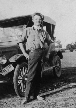
| Description | : | Jack Edgar Dulaney, 68, of River Road, Petersburg, died Wednesday, January 14, 1998 in Southside Regional Medical Center. He was born in Floyd County. Mr. Dulaney served with the U.S. Army during World War II and the Korean Conflict, a member of the Colonial Heights American Legion #284 and V.F.W. Post #637, Hopewell and was a retired inspector with Allied-Signal Corp. Surviving are his wife, Cleavie Swim Dulaney of Petersburg; two daughters, Angela M. Johnson of Hopewell and Linda D. Elmore of Petersburg; two sons, Teddy R. Dulaney of Savage, Md., and Robert E. Dulaney of Chester; a stepdaughter, Vickie... Read More |
frequently asked questions (FAQ):
-
Where is Jack Edgar Dulaney's memorial?
Jack Edgar Dulaney's memorial is located at: Christ Church Churchyard, Woodford, Metropolitan Borough of Stockport, England.
-
When did Jack Edgar Dulaney death?
Jack Edgar Dulaney death on 14 Jan 1998 in Petersburg City, Virginia, USA
-
Where are the coordinates of the Jack Edgar Dulaney's memorial?
Latitude: 53.3375900
Longitude: -2.1733800
Family Members:
Parent
Spouse

Flowers:


Nearby Cemetories:
1. Christ Church Churchyard
Woodford, Metropolitan Borough of Stockport, England
Coordinate: 53.3375900, -2.1733800
2. Bramhall Baptist Church
Bramhall, Metropolitan Borough of Stockport, England
Coordinate: 53.3509311, -2.1644365
3. Dean Row Chapelyard
Wilmslow, Cheshire East Unitary Authority, England
Coordinate: 53.3304820, -2.1951770
4. St Chad
Handforth, Cheshire East Unitary Authority, England
Coordinate: 53.3485000, -2.2148100
5. Wilmslow Cemetery
Wilmslow, Cheshire East Unitary Authority, England
Coordinate: 53.3374170, -2.2236590
6. All Saints Churchyard
Cheadle Hulme, Metropolitan Borough of Stockport, England
Coordinate: 53.3669444, -2.1863889
7. St George Churchyard
Poynton, Cheshire East Unitary Authority, England
Coordinate: 53.3490610, -2.1231260
8. St. Bartholomew Churchyard
Wilmslow, Cheshire East Unitary Authority, England
Coordinate: 53.3301250, -2.2296900
9. Heald Green United Reformed Church
Heald Green, Metropolitan Borough of Stockport, England
Coordinate: 53.3674480, -2.2165710
10. St Peter Churchyard
Prestbury, Cheshire East Unitary Authority, England
Coordinate: 53.2892070, -2.1505100
11. Norbury St Thomas Churchyard
Hazel Grove, Metropolitan Borough of Stockport, England
Coordinate: 53.3761440, -2.1160440
12. St. John's Churchyard
Wilmslow, Cheshire East Unitary Authority, England
Coordinate: 53.3122370, -2.2532400
13. Cheadle Cemetery
Cheadle, Metropolitan Borough of Stockport, England
Coordinate: 53.3927610, -2.2054690
14. St. Christopher Churchyard
Pott Shrigley, Cheshire East Unitary Authority, England
Coordinate: 53.3096500, -2.0842900
15. Alderley Edge Cemetery
Alderley Edge, Cheshire East Unitary Authority, England
Coordinate: 53.2995180, -2.2530880
16. Stockport Cemetery and Crematorium
Stockport, Metropolitan Borough of Stockport, England
Coordinate: 53.3979110, -2.1511430
17. St Mary's Churchyard
Cheadle, Metropolitan Borough of Stockport, England
Coordinate: 53.3944820, -2.2176205
18. St John the Baptist Churchyard
Bollington, Cheshire East Unitary Authority, England
Coordinate: 53.2969600, -2.0926100
19. Wesleyan Chapel
Edgeley, Metropolitan Borough of Stockport, England
Coordinate: 53.4019700, -2.1673860
20. Mill Lane Cemetery
Cheadle, Metropolitan Borough of Stockport, England
Coordinate: 53.3992000, -2.2150800
21. St Thomas Churchyard
Stockport, Metropolitan Borough of Stockport, England
Coordinate: 53.4036000, -2.1550000
22. St Marys Churchyard
Nether Alderley, Cheshire East Unitary Authority, England
Coordinate: 53.2820200, -2.2388500
23. Quaker Burying Ground
Mobberley, Cheshire East Unitary Authority, England
Coordinate: 53.3174300, -2.2872500
24. Ringway St. Mary and All Saints Churchyard
Altrincham, Metropolitan Borough of Trafford, England
Coordinate: 53.3587900, -2.2885800