

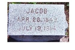
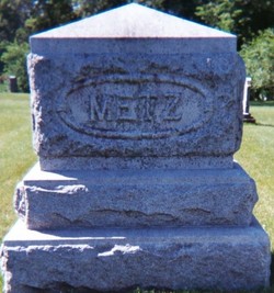
Jacob Metz
| Birth | : | 28 Apr 1850 Marshallville, Wayne County, Ohio, USA |
| Death | : | 19 Jul 1914 Woden, Hancock County, Iowa, USA |
| Burial | : | Ss Mary and Clement Churchyard, Clavering, Uttlesford District, England |
| Coordinate | : | 51.9653720, 0.1393760 |
| Description | : | Jacob Metz (Civil War Veteran) Born: April 28, 1849* (Marshallville, Wayne Co., OH) Died: July 19, 1914 (Rockford, Floyd Co., IA)** Residence at time of enlistment: Addison, Washington Co., WI Enlisted: March 1, 1865 as a Pvt.in the 7th WI Infantry, Co. D (IRON BRIGADE) Mustered Out: July 3, 1865 This info supplied by Don Strube. *Jacob was born in 1850. According to the 1850 Federal census the name column states: "The Name of every Person whose usual place of abode on the first day of June 1850 in this family." His age is listed as 2/12, therefore, he was born in 1850. He may have lied about... Read More |
frequently asked questions (FAQ):
-
Where is Jacob Metz's memorial?
Jacob Metz's memorial is located at: Ss Mary and Clement Churchyard, Clavering, Uttlesford District, England.
-
When did Jacob Metz death?
Jacob Metz death on 19 Jul 1914 in Woden, Hancock County, Iowa, USA
-
Where are the coordinates of the Jacob Metz's memorial?
Latitude: 51.9653720
Longitude: 0.1393760
Family Members:
Parent
Spouse
Siblings

Children
Flowers:


Nearby Cemetories:
1. Ss Mary and Clement Churchyard
Clavering, Uttlesford District, England
Coordinate: 51.9653720, 0.1393760
2. All Saints Churchyard
Rickling, Uttlesford District, England
Coordinate: 51.9615100, 0.1798200
3. St Margaret Churchyard
Arkesden, Uttlesford District, England
Coordinate: 51.9897000, 0.1571200
4. Saint Mary Churchyard
Meesden, East Hertfordshire District, England
Coordinate: 51.9728000, 0.0934270
5. St. John The Evangelist Churchyard
Langley, Uttlesford District, England
Coordinate: 51.9969356, 0.0995640
6. Quendon Churchyard
Quendon, Uttlesford District, England
Coordinate: 51.9535800, 0.2038700
7. St Mary the Virgin Churchyard
Furneux Pelham, East Hertfordshire District, England
Coordinate: 51.9316710, 0.0808950
8. St Mary the Virgin Churchyard
Newport, Uttlesford District, England
Coordinate: 51.9845000, 0.2135600
9. The Hamlet Church Cemetery
Duddenhoe End, Uttlesford District, England
Coordinate: 52.0145269, 0.1285385
10. St Peter Churchyard
Ugley, Uttlesford District, England
Coordinate: 51.9364900, 0.2086500
11. St. Mary the Virgin Churchyard
Wendens Ambo, Uttlesford District, England
Coordinate: 52.0049490, 0.2029250
12. St George Churchyard
Anstey, East Hertfordshire District, England
Coordinate: 51.9766990, 0.0431300
13. St Mary the Virgin Churchyard
Widdington, Uttlesford District, England
Coordinate: 51.9629600, 0.2397600
14. St. Mary the Virgin Churchyard
Farnham, Uttlesford District, England
Coordinate: 51.9020340, 0.1517660
15. Holy Trinity Churchyard
Chrishall, Uttlesford District, England
Coordinate: 52.0276500, 0.1139577
16. Great Hormead St Nicholas Churchyard
Hormead, East Hertfordshire District, England
Coordinate: 51.9469500, 0.0353300
17. St Nicholas Churchyard
Little Chishill, South Cambridgeshire District, England
Coordinate: 52.0154690, 0.0654890
18. Little Hormead St Mary Churchyard
Hormead, East Hertfordshire District, England
Coordinate: 51.9428430, 0.0331630
19. St. Nicholas Churchyard
Elmdon, Uttlesford District, England
Coordinate: 52.0359900, 0.1294000
20. St Mary's Churchyard
Albury, East Hertfordshire District, England
Coordinate: 51.9026500, 0.0852920
21. St Mary the Virgin Churchyard
Henham, Uttlesford District, England
Coordinate: 51.9342500, 0.2456300
22. St Mary the Virgin and All Saints Churchyard
Debden, Uttlesford District, England
Coordinate: 51.9759030, 0.2568160
23. Hare Street Benson Grounds
Buntingford, East Hertfordshire District, England
Coordinate: 51.9492640, 0.0221120
24. St Swithin Churchyard
Great Chishill, South Cambridgeshire District, England
Coordinate: 52.0300090, 0.0715990