
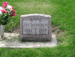

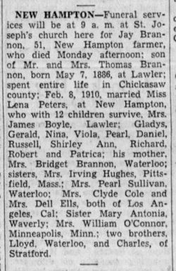
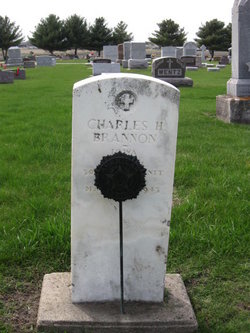
James “Jay” Brannon
| Birth | : | 7 May 1886 Lawler, Chickasaw County, Iowa, USA |
| Death | : | 4 Apr 1938 Jacksonville Township, Chickasaw County, Iowa, USA |
| Burial | : | High Street Cemetery, Greenfield, Franklin County, USA |
| Coordinate | : | 42.6044840, -72.5806660 |
| Description | : | Find the grave in the Southwest quarter of the Northeast section (quarter) of the cemetery. To find it; enter the middle gate, go as far as the red colored Walter & Martha Kennedy monument on your right (it's next to the driveway). The monument you want will be ahead of you and off to the right. The cemetery has a circular driveway in the center. From it are driveways that go, North, East, South and West, dividing the cemetery into (unequal) quarters. Please feel free to contact me if anything needs correcting or if you'd like additional photos or information posted. ∼wife... Read More |
frequently asked questions (FAQ):
-
Where is James “Jay” Brannon's memorial?
James “Jay” Brannon's memorial is located at: High Street Cemetery, Greenfield, Franklin County, USA.
-
When did James “Jay” Brannon death?
James “Jay” Brannon death on 4 Apr 1938 in Jacksonville Township, Chickasaw County, Iowa, USA
-
Where are the coordinates of the James “Jay” Brannon's memorial?
Latitude: 42.6044840
Longitude: -72.5806660
Family Members:
Parent
Spouse
Siblings


Children
Flowers:


Nearby Cemetories:
1. High Street Cemetery
Greenfield, Franklin County, USA
Coordinate: 42.6044840, -72.5806660
2. Federal Street Cemetery
Greenfield, Franklin County, USA
Coordinate: 42.5941400, -72.5977300
3. Fairway Avenue Cemetery
Montague, Franklin County, USA
Coordinate: 42.5924270, -72.5646970
4. Burnham Cemetery
Montague, Franklin County, USA
Coordinate: 42.5875300, -72.5720140
5. Springdale Cemetery
Montague, Franklin County, USA
Coordinate: 42.5884700, -72.5530900
6. Green River Cemetery
Greenfield, Franklin County, USA
Coordinate: 42.5804400, -72.6052500
7. Saint Annes Cemetery
Montague, Franklin County, USA
Coordinate: 42.5861300, -72.5480600
8. Lower Meadow Cemetery
Greenfield, Franklin County, USA
Coordinate: 42.5945600, -72.6200300
9. Saint Marys Cemetery
Montague, Franklin County, USA
Coordinate: 42.5852200, -72.5475100
10. Riverside Cemetery
Gill, Franklin County, USA
Coordinate: 42.6156006, -72.5410995
11. Old Catholic Cemetery
Greenfield, Franklin County, USA
Coordinate: 42.5795753, -72.6064215
12. Our Lady of Czestochowa Cemetery
Montague, Franklin County, USA
Coordinate: 42.5846000, -72.5469400
13. Aaron Clark Memorial Cemetery
Montague, Franklin County, USA
Coordinate: 42.5836200, -72.5471600
14. Log Plain Cemetery
Greenfield, Franklin County, USA
Coordinate: 42.6378320, -72.5725800
15. Calvary Cemetery
Greenfield, Franklin County, USA
Coordinate: 42.5764008, -72.6138992
16. Greenfield Hebrew Congregation Cemetery
Greenfield, Franklin County, USA
Coordinate: 42.6409410, -72.5653360
17. Mater Dolorosa Cemetery
Greenfield, Franklin County, USA
Coordinate: 42.5758000, -72.6165000
18. North Meadows Cemetery
Greenfield, Franklin County, USA
Coordinate: 42.6171989, -72.6333008
19. Country Farms Cemetery
Greenfield, Franklin County, USA
Coordinate: 42.6393900, -72.6165400
20. East Deerfield Cemetery
Deerfield, Franklin County, USA
Coordinate: 42.5555992, -72.5642014
21. North Cemetery
Deerfield, Franklin County, USA
Coordinate: 42.5635100, -72.6249200
22. West Gill Cemetery
Gill, Franklin County, USA
Coordinate: 42.6442700, -72.5280500
23. East Mineral Road Cemetery
Montague, Franklin County, USA
Coordinate: 42.5810500, -72.5086300
24. Baptist Cemetery
Deerfield, Franklin County, USA
Coordinate: 42.5555992, -72.6258011