

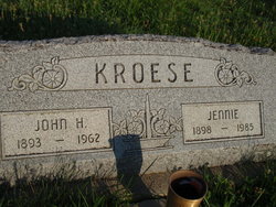
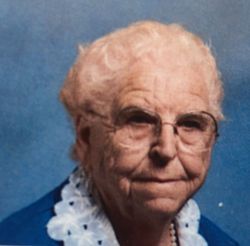
Jennie Fischer Kroese
| Birth | : | 29 Jun 1898 Holland, Lancaster County, Nebraska, USA |
| Death | : | 31 Jan 1985 Firth, Lancaster County, Nebraska, USA |
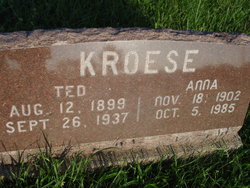
| Burial | : | Pella Cemetery, Panama, Lancaster County, USA |
| Coordinate | : | 40.5555992, -96.5014038 |
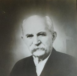
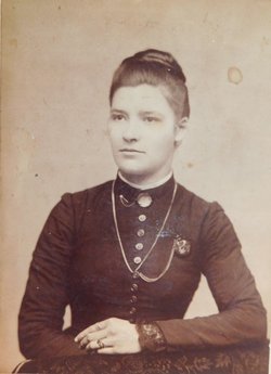
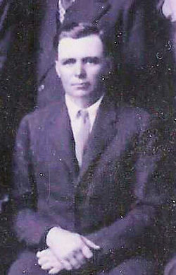
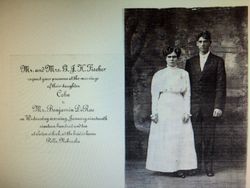
| Description | : | Jennie Fischer was born on the family farm in rural Holland, Hickman, Lancaster County, Nebraska area. She move with her family to the Pella community, rural Adams, Lancaster County area. She received elementary education at Lancaster County Public Schools, District 20, "Wooden Shoe" located at 176th street and Firth road in rural Adams, Lancaster County, Nebraska. She was a member of the Pella Reformed Church, rural Adams, Nebraska and met here husband there. Jennie and John H. Kroese were married on November 10, 1919 in Lincoln, Lancaster County, Nebraska. They started married life on a farm owned by John's... Read More |
frequently asked questions (FAQ):
-
Where is Jennie Fischer Kroese's memorial?
Jennie Fischer Kroese's memorial is located at: Pella Cemetery, Panama, Lancaster County, USA.
-
When did Jennie Fischer Kroese death?
Jennie Fischer Kroese death on 31 Jan 1985 in Firth, Lancaster County, Nebraska, USA
-
Where are the coordinates of the Jennie Fischer Kroese's memorial?
Latitude: 40.5555992
Longitude: -96.5014038
Family Members:
Parent
Spouse
Siblings

Children


Flowers:


Nearby Cemetories:
1. Pella Cemetery
Panama, Lancaster County, USA
Coordinate: 40.5555992, -96.5014038
2. Panama Cemetery
Panama, Lancaster County, USA
Coordinate: 40.5821991, -96.5255966
3. Latrobe Cemetery
Sterling, Johnson County, USA
Coordinate: 40.5151000, -96.4557000
4. Solon Cemetery
Otoe County, USA
Coordinate: 40.5917015, -96.4436035
5. Mount Zion Cemetery
Otoe County, USA
Coordinate: 40.6250000, -96.4449997
6. Holland Cemetery
Holland, Lancaster County, USA
Coordinate: 40.5957985, -96.5997009
7. Firth Cemetery
Firth, Lancaster County, USA
Coordinate: 40.5250015, -96.6085968
8. Rosehill Cemetery
Douglas, Otoe County, USA
Coordinate: 40.5845940, -96.3867900
9. Saint Martins Cemetery
Douglas, Otoe County, USA
Coordinate: 40.5844002, -96.3861008
10. Swiggart Family Cemetery
Hickman, Lancaster County, USA
Coordinate: 40.6181060, -96.5909170
11. Dietz Cemetery
Firth, Lancaster County, USA
Coordinate: 40.5449982, -96.6286011
12. Highland Cemetery
Adams, Gage County, USA
Coordinate: 40.4580994, -96.5196991
13. Immanuel Cemetery
Sterling, Johnson County, USA
Coordinate: 40.4692001, -96.4253006
14. Saint Johns Lutheran Cemetery
Cortland, Gage County, USA
Coordinate: 40.5078300, -96.6252700
15. Weber Cemetery
Sterling, Johnson County, USA
Coordinate: 40.4581000, -96.4177000
16. Hickman Cemetery
Hickman, Lancaster County, USA
Coordinate: 40.6210861, -96.6292496
17. Stagecoach Lake Cemetery
Hickman, Lancaster County, USA
Coordinate: 40.6028830, -96.6447370
18. Dughman Cemetery
Douglas, Otoe County, USA
Coordinate: 40.5705986, -96.3452988
19. Klaus Family Cemetery
Palmyra, Otoe County, USA
Coordinate: 40.6680660, -96.4398380
20. Saint John North Lutheran Cemetery
Sterling, Johnson County, USA
Coordinate: 40.4689500, -96.3878500
21. Grandview Cemetery
Gage County, USA
Coordinate: 40.4617004, -96.6091995
22. Bennet Cemetery
Bennet, Lancaster County, USA
Coordinate: 40.6889572, -96.5079193
23. Hooker Cemetery
Adams, Gage County, USA
Coordinate: 40.4207993, -96.4732971
24. Sunnyside Cemetery
Cortland, Gage County, USA
Coordinate: 40.4799200, -96.6511800