

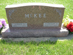
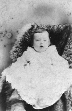
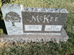
Jennie Opal “Dimple” Fletcher McKee
| Birth | : | 24 Dec 1892 Cumberland, Cass County, Iowa, USA |
| Death | : | 21 Aug 1971 Atlantic, Cass County, Iowa, USA |
| Burial | : | St Peter's Churchyard, Frimley, Surrey Heath Borough, England |
| Coordinate | : | 51.3149770, -0.7393330 |
| Plot | : | 10 |
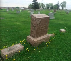
| Description | : | Funeral services were held for Jennie (Dimple) McKee Monday, August 28 at the Massena Christian Church at two o'clock, with Rev. Paul Akin officiating. Mrs. Glen Spieker accompanied Mrs. Oscar Ryan and Mrs. Bob Blankenship as they sang "The Beautiful Garden of Prayer" and "Near to the Heart of God." In charge of flowers were Mr. and Mrs. Garner Thompson and Mr. and Mrs. Raymond Bissell. Casket bearers were John Lary, Jim McKee, Jack McKee, Richard Antisdel, Charles Brown, and Marlin Kinney. Honorary casket bearers were Gary Antisdel, Dan McKee, Jeffrey Madsen, Jon Madsen, Gene Huss, Gary Bissell, Karl Swanson, and Larry... Read More |
frequently asked questions (FAQ):
-
Where is Jennie Opal “Dimple” Fletcher McKee's memorial?
Jennie Opal “Dimple” Fletcher McKee's memorial is located at: St Peter's Churchyard, Frimley, Surrey Heath Borough, England.
-
When did Jennie Opal “Dimple” Fletcher McKee death?
Jennie Opal “Dimple” Fletcher McKee death on 21 Aug 1971 in Atlantic, Cass County, Iowa, USA
-
Where are the coordinates of the Jennie Opal “Dimple” Fletcher McKee's memorial?
Latitude: 51.3149770
Longitude: -0.7393330
Family Members:
Parent

Spouse
Siblings
Children

Flowers:


Nearby Cemetories:
1. St Peter's Churchyard
Frimley, Surrey Heath Borough, England
Coordinate: 51.3149770, -0.7393330
2. Ship Lane Cemetery
Farnborough, Rushmoor Borough, England
Coordinate: 51.3057800, -0.7488900
3. Church of Saint Francis of Assisi
Camberley, Surrey Heath Borough, England
Coordinate: 51.3311000, -0.7350400
4. St Michael's Abbey
Farnborough, Rushmoor Borough, England
Coordinate: 51.2971140, -0.7497110
5. Deepcut Military Cemetery
Deepcut, Surrey Heath Borough, England
Coordinate: 51.3062170, -0.7049060
6. St. Peter's Churchyard
Farnborough, Rushmoor Borough, England
Coordinate: 51.2924100, -0.7499300
7. Victoria Road Cemetery
Farnborough, Rushmoor Borough, England
Coordinate: 51.2941300, -0.7593900
8. St. Michael‘s Churchyard
Camberley, Surrey Heath Borough, England
Coordinate: 51.3367810, -0.7596560
9. Holy Trinity Churchyard
Blackwater, Hart District, England
Coordinate: 51.3269100, -0.7773800
10. Hawley Cemetery
Blackwater, Hart District, England
Coordinate: 51.3280700, -0.7778700
11. St. John the Baptist Churchyard
Farnborough, Rushmoor Borough, England
Coordinate: 51.2973050, -0.7819310
12. Sandhurst Royal Military Academy Cemetery
Sandhurst, Bracknell Forest Borough, England
Coordinate: 51.3431310, -0.7675360
13. Heathlands Cemetery
Yateley, Hart District, England
Coordinate: 51.3308800, -0.8172500
14. St. Michael's and All Angels Churchyard
Sandhurst, Bracknell Forest Borough, England
Coordinate: 51.3498240, -0.8155500
15. St Michael and All Angels Churchyard
Pirbright, Guildford Borough, England
Coordinate: 51.2945800, -0.6500000
16. Aldershot Military Cemetery
Aldershot, Rushmoor Borough, England
Coordinate: 51.2554779, -0.7449350
17. Broadmoor Asylum Cemetery
Crowthorne, Bracknell Forest Borough, England
Coordinate: 51.3694160, -0.7793430
18. St Peter Churchyard
Yateley, Hart District, England
Coordinate: 51.3411500, -0.8278000
19. Ash War Memorial
Ash, Guildford Borough, England
Coordinate: 51.2546746, -0.7157783
20. Brookwood Military Cemetery
Brookwood, Woking Borough, England
Coordinate: 51.3012619, -0.6419710
21. Brookwood 1939-1945 Memorial
Brookwood, Woking Borough, England
Coordinate: 51.3002815, -0.6409460
22. Brookwood 1914-1918 Memorial
Brookwood, Woking Borough, England
Coordinate: 51.3007800, -0.6403300
23. Brookwood American Military Cemetery
Brookwood, Woking Borough, England
Coordinate: 51.3014080, -0.6397010
24. Aldershot Jewish Cemetery
Aldershot, Rushmoor Borough, England
Coordinate: 51.2508900, -0.7463000