
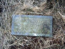
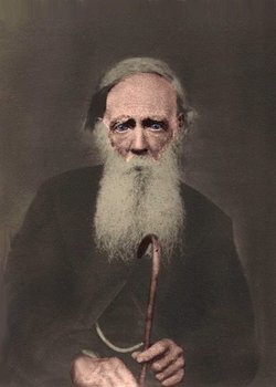
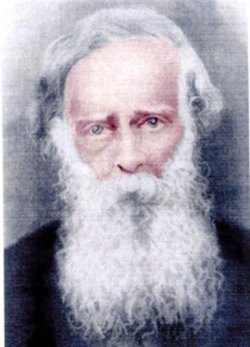
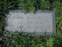
John A Fariss
| Birth | : | 13 Aug 1812 Halifax County, Virginia, USA |
| Death | : | 8 Apr 1892 Carroll County, Virginia, USA |
| Burial | : | Grantham Cemetery and Crematorium, Grantham, South Kesteven District, England |
| Coordinate | : | 52.9095320, -0.6326120 |
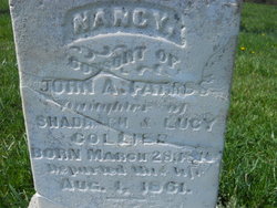
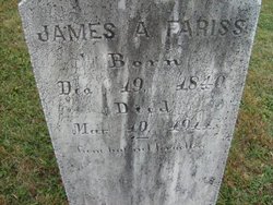
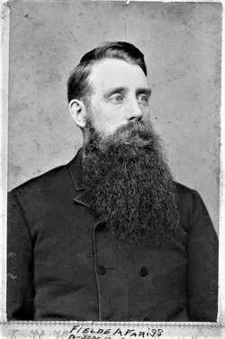
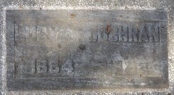
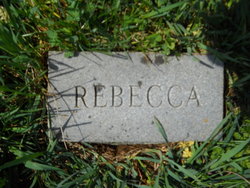
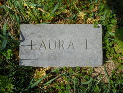
| Description | : | John A Fariss supposedly has 10 children born to Nancy Collier and 10 children born to Hannah Gallimore. The children identified are William Jackson, James Anderson, Mary Jane, Victoria, Fielden A, Lucy Ann, Rebecca, and Sarah Elizabeth born to Nancy Collier. Laura L may also have been a child of theirs born between 1841 - 1846. The children born to Hannah Gallimore are Valeria Lee, Laura L, Peter, George Washington, David, Cora Ella, Ruth Clyde, Henry Alfred, and Wildie Catherine. |
frequently asked questions (FAQ):
-
Where is John A Fariss's memorial?
John A Fariss's memorial is located at: Grantham Cemetery and Crematorium, Grantham, South Kesteven District, England.
-
When did John A Fariss death?
John A Fariss death on 8 Apr 1892 in Carroll County, Virginia, USA
-
Where are the coordinates of the John A Fariss's memorial?
Latitude: 52.9095320
Longitude: -0.6326120
Family Members:
Spouse
Children
Flowers:


Nearby Cemetories:
1. Grantham Cemetery and Crematorium
Grantham, South Kesteven District, England
Coordinate: 52.9095320, -0.6326120
2. St. Wulfram Churchyard
Grantham, South Kesteven District, England
Coordinate: 52.9148180, -0.6408520
3. Manthorpe Road Old Cemetery
Grantham, South Kesteven District, England
Coordinate: 52.9173900, -0.6409900
4. St John the Evangelist Churchyard
Manthorpe, South Kesteven District, England
Coordinate: 52.9306320, -0.6323160
5. St. Guthlac Churchyard
Little Ponton, South Kesteven District, England
Coordinate: 52.8796100, -0.6271200
6. St Sebastian Churchyard
Great Gonerby, South Kesteven District, England
Coordinate: 52.9329260, -0.6657700
7. St John the Baptist Churchyard
Londonthorpe, South Kesteven District, England
Coordinate: 52.9312060, -0.5837350
8. St. Peter and St. Paul's Churchyard
Belton, South Kesteven District, England
Coordinate: 52.9451000, -0.6177000
9. All Saints Churchyard
Barrowby, South Kesteven District, England
Coordinate: 52.9186420, -0.6946810
10. St. Mary Magdalene Churchyard
Old Somerby, South Kesteven District, England
Coordinate: 52.8944900, -0.5672830
11. St Mary and St Peter Churchyard
Harlaxton, South Kesteven District, England
Coordinate: 52.8836860, -0.6895640
12. All Saints Churchyard
Stroxton, South Kesteven District, England
Coordinate: 52.8695300, -0.6609700
13. Holy Cross Churchyard
Great Ponton, South Kesteven District, England
Coordinate: 52.8638270, -0.6275570
14. St Marys Churchyard
Syston, South Kesteven District, England
Coordinate: 52.9578420, -0.6172940
15. St Nicholas Churchyard
Barkston, South Kesteven District, England
Coordinate: 52.9629960, -0.6129380
16. St Andrew Churchyard
Denton, South Kesteven District, England
Coordinate: 52.8828830, -0.7151840
17. St. Lawrence Churchyard
Sedgebrook, South Kesteven District, England
Coordinate: 52.9329460, -0.7256530
18. Saint Andrew Churchyard
Boothby Pagnell, South Kesteven District, England
Coordinate: 52.8660600, -0.5578600
19. St. Peter's Churchyard
Ropsley, South Kesteven District, England
Coordinate: 52.8959736, -0.5259958
20. Ropsley Churchyard Extension
Ropsley, South Kesteven District, England
Coordinate: 52.8958475, -0.5254147
21. St James Churchyard
Allington, South Kesteven District, England
Coordinate: 52.9525695, -0.7245301
22. St. Wilfrid Churchyard
Honington, South Kesteven District, England
Coordinate: 52.9795600, -0.5965700
23. St Thomas a Beckett Churchyard
Bassingthorpe, South Kesteven District, England
Coordinate: 52.8457500, -0.5669900
24. St James Churchyard
Woolsthorpe-by-Belvoir, South Kesteven District, England
Coordinate: 52.8957880, -0.7578370