
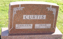
John Dean Curtis
| Birth | : | 19 Sep 1935 Taylor County, Iowa, USA |
| Death | : | 25 Apr 1963 Omaha, Douglas County, Nebraska, USA |
| Burial | : | Mount Calvary Cemetery, Topeka, Shawnee County, USA |
| Coordinate | : | 39.0532990, -95.7360992 |
| Description | : | Bedford Times-Press (Bedford, Iowa), Thursday, May 2, 1963, [p. 1] Death Takes Dean Curtis Funeral services were held last Saturday for Dean Curtis, 27, at the Roland Funeral Home in Corning. Curtis died April 25 in the St. Joseph Hospital in Omaha after more than two months in the hospital with a brain tumor. Interment was at the Guss cemetery. In February this Taylor County farmer became seriously ill. Surgery was found necessary and he had been in serious condition since. The esteem friends hold for the family was shown at the farm four miles east of Guss by many events during his hospitalization.... Read More |
frequently asked questions (FAQ):
-
Where is John Dean Curtis's memorial?
John Dean Curtis's memorial is located at: Mount Calvary Cemetery, Topeka, Shawnee County, USA.
-
When did John Dean Curtis death?
John Dean Curtis death on 25 Apr 1963 in Omaha, Douglas County, Nebraska, USA
-
Where are the coordinates of the John Dean Curtis's memorial?
Latitude: 39.0532990
Longitude: -95.7360992
Family Members:
Parent

Spouse
Flowers:


Nearby Cemetories:
1. Mount Calvary Cemetery
Topeka, Shawnee County, USA
Coordinate: 39.0532990, -95.7360992
2. Memorial Park Cemetery
Topeka, Shawnee County, USA
Coordinate: 39.0619011, -95.7221985
3. Mount Hope Cemetery
Topeka, Shawnee County, USA
Coordinate: 39.0367393, -95.7386703
4. Saint Davids Episcopal Church Columbarium
Topeka, Shawnee County, USA
Coordinate: 39.0369860, -95.7259480
5. Security Benefit Association Cemetery
Topeka, Shawnee County, USA
Coordinate: 39.0630989, -95.7606583
6. Topeka State Hospital Cemetery
Topeka, Shawnee County, USA
Coordinate: 39.0671005, -95.7080994
7. Westminster Presbyterian Church Memorial Garden
Topeka, Shawnee County, USA
Coordinate: 39.0430400, -95.7021700
8. Carnegie Hall
Topeka, Shawnee County, USA
Coordinate: 39.0350600, -95.6999100
9. Ritchie Cemetery
Topeka, Shawnee County, USA
Coordinate: 39.0228010, -95.7027530
10. Grace Episcopal Cathedral Columbarium
Topeka, Shawnee County, USA
Coordinate: 39.0511284, -95.6843719
11. Grace Episcopal Cathedral Sanctuary
Topeka, Shawnee County, USA
Coordinate: 39.0506925, -95.6839273
12. Abram Burnett Burial Site
Topeka, Shawnee County, USA
Coordinate: 39.0102997, -95.7685776
13. Mission Center Cemetery
Topeka, Shawnee County, USA
Coordinate: 39.0145493, -95.7819290
14. Prairie Home Cemetery
Topeka, Shawnee County, USA
Coordinate: 39.1077118, -95.7482910
15. Curtis Family Cemetery
North Topeka, Shawnee County, USA
Coordinate: 39.0792870, -95.6702270
16. West Lawn Memorial Gardens
Topeka, Shawnee County, USA
Coordinate: 39.0518112, -95.8167419
17. Bennie Lee Graham Memorial Cemetery
Shawnee County, USA
Coordinate: 39.1020584, -95.6836472
18. Foster Cemetery
Topeka, Shawnee County, USA
Coordinate: 38.9942017, -95.7061005
19. Topeka Cemetery
Topeka, Shawnee County, USA
Coordinate: 39.0388985, -95.6528015
20. Rochester Cemetery
Topeka, Shawnee County, USA
Coordinate: 39.1044006, -95.6800003
21. Mount Auburn Cemetery
Topeka, Shawnee County, USA
Coordinate: 39.0393982, -95.6500015
22. Elevation Cemetery
Shawnee County, USA
Coordinate: 38.9832993, -95.7613983
23. Half-Day Cemetery
Elmont, Shawnee County, USA
Coordinate: 39.1584702, -95.7143402
24. Valencia Cemetery
Valencia, Shawnee County, USA
Coordinate: 39.0586014, -95.8806000