

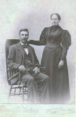
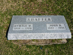
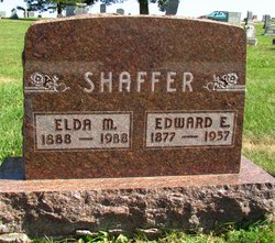
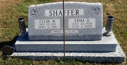
John Demas Shaffer
| Birth | : | 6 Jun 1882 Piatt County, Illinois, USA |
| Death | : | 24 May 1955 Clearfield, Taylor County, Iowa, USA |
| Burial | : | St Peter's Church, Newenden, Ashford Borough, England |
| Coordinate | : | 51.0157750, 0.6137190 |
| Description | : | Married Myrtle May Ethington, June 6, 1909, Clearfield, Taylor Co., IA. 9 children. |
frequently asked questions (FAQ):
-
Where is John Demas Shaffer's memorial?
John Demas Shaffer's memorial is located at: St Peter's Church, Newenden, Ashford Borough, England.
-
When did John Demas Shaffer death?
John Demas Shaffer death on 24 May 1955 in Clearfield, Taylor County, Iowa, USA
-
Where are the coordinates of the John Demas Shaffer's memorial?
Latitude: 51.0157750
Longitude: 0.6137190
Family Members:
Parent
Spouse
Siblings

Children
Flowers:


Nearby Cemetories:
1. St Peter's Church
Newenden, Ashford Borough, England
Coordinate: 51.0157750, 0.6137190
2. Northiam Cemetery
Northiam, Rother District, England
Coordinate: 50.9926872, 0.5984631
3. St Mary's Churchyard
Northiam, Rother District, England
Coordinate: 50.9911250, 0.6061390
4. All Saints Churchyard
Beckley, Rother District, England
Coordinate: 50.9832400, 0.6245300
5. St. Mary the Virgin Churchyard
Rolvenden, Ashford Borough, England
Coordinate: 51.0506590, 0.6310280
6. Ewhurst Green Churchyard
Ewhurst, Rother District, England
Coordinate: 50.9924300, 0.5572900
7. Saint Giles' Churchyard
Bodiam, Rother District, England
Coordinate: 51.0074800, 0.5393000
8. St Theresa's Catholic Church
Northiam, Rother District, England
Coordinate: 50.9654510, 0.5958960
9. St. George Parish Churchyard
Benenden, Tunbridge Wells Borough, England
Coordinate: 51.0648720, 0.5794570
10. Wittersham
Wittersham, Ashford Borough, England
Coordinate: 51.0115600, 0.7016000
11. St John the Baptist
Small Hythe, Ashford Borough, England
Coordinate: 51.0396260, 0.6996060
12. Tenterden Cemetery
Tenterden, Ashford Borough, England
Coordinate: 51.0676820, 0.6737140
13. BroadOak Methodist Chapel
Brede, Rother District, England
Coordinate: 50.9487320, 0.6015820
14. Saint Peter & Saint Paul Church Churchyard
Peasmarsh, Rother District, England
Coordinate: 50.9645500, 0.6859200
15. Station Road Extension
Tenterden, Ashford Borough, England
Coordinate: 51.0686640, 0.6852830
16. Hawkhurst Cemetery
Hawkhurst, Tunbridge Wells Borough, England
Coordinate: 51.0302300, 0.5051300
17. St. Mildred's Churchyard
Tenterden, Ashford Borough, England
Coordinate: 51.0686264, 0.6870960
18. St. Laurence Churchyard
Hawkhurst, Tunbridge Wells Borough, England
Coordinate: 51.0377240, 0.5031610
19. Unitarian Old Meeting House
Tenterden, Ashford Borough, England
Coordinate: 51.0717468, 0.6906880
20. Saint Mary Churchyard
Udimore, Rother District, England
Coordinate: 50.9399770, 0.6508420
21. Iden Burial Ground
Iden, Rother District, England
Coordinate: 50.9813000, 0.7275300
22. All Saints Churchyard
Iden, Rother District, England
Coordinate: 50.9812930, 0.7275500
23. St Mary the Virgin Churchyard
Salehurst, Rother District, England
Coordinate: 50.9910170, 0.4911260
24. St George Churchyard
Brede, Rother District, England
Coordinate: 50.9349140, 0.5963830