
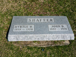
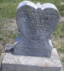
Myrtle May Ethington Shaffer
| Birth | : | 20 Nov 1889 Clearfield, Taylor County, Iowa, USA |
| Death | : | 27 Sep 1970 Lenox, Taylor County, Iowa, USA |
| Burial | : | St Peter's Church, Newenden, Ashford Borough, England |
| Coordinate | : | 51.0157750, 0.6137190 |
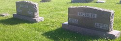
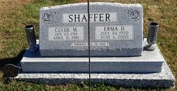
| Description | : | Married John Demas Shaffer, June 6, 1909, Clearfield, Taylor Co., IA. 9 Children. ~~~~~~~~~ The Lenox Time Table Thursday October 1, 1970 Mrs. Myrtle Shaffer, 80, a longtime resident of Clearfield, died at the Lenox Nursing Home Sunday morning. She had been a resident there but a short time. Survivors include four daughters, Mrs. Fern Spurrier of Clearfield, Mrs. Louise French of Bedford, Mrs. Opal McMichael of Grimes and Mrs. M. Henderson of Lenox. Four sons also survive, Clyde, Donovan, Delbert and Gilbert, all of Boulder, Colorado. Twenty two grandchildren and 34 great grandchildren mourn her loss. She also leaves two brothers, Clarence Ethington of... Read More |
frequently asked questions (FAQ):
-
Where is Myrtle May Ethington Shaffer's memorial?
Myrtle May Ethington Shaffer's memorial is located at: St Peter's Church, Newenden, Ashford Borough, England.
-
When did Myrtle May Ethington Shaffer death?
Myrtle May Ethington Shaffer death on 27 Sep 1970 in Lenox, Taylor County, Iowa, USA
-
Where are the coordinates of the Myrtle May Ethington Shaffer's memorial?
Latitude: 51.0157750
Longitude: 0.6137190
Family Members:
Parent
Spouse

Siblings
Children

Flowers:


Nearby Cemetories:
1. St Peter's Church
Newenden, Ashford Borough, England
Coordinate: 51.0157750, 0.6137190
2. Northiam Cemetery
Northiam, Rother District, England
Coordinate: 50.9926872, 0.5984631
3. St Mary's Churchyard
Northiam, Rother District, England
Coordinate: 50.9911250, 0.6061390
4. All Saints Churchyard
Beckley, Rother District, England
Coordinate: 50.9832400, 0.6245300
5. St. Mary the Virgin Churchyard
Rolvenden, Ashford Borough, England
Coordinate: 51.0506590, 0.6310280
6. Ewhurst Green Churchyard
Ewhurst, Rother District, England
Coordinate: 50.9924300, 0.5572900
7. Saint Giles' Churchyard
Bodiam, Rother District, England
Coordinate: 51.0074800, 0.5393000
8. St Theresa's Catholic Church
Northiam, Rother District, England
Coordinate: 50.9654510, 0.5958960
9. St. George Parish Churchyard
Benenden, Tunbridge Wells Borough, England
Coordinate: 51.0648720, 0.5794570
10. Wittersham
Wittersham, Ashford Borough, England
Coordinate: 51.0115600, 0.7016000
11. St John the Baptist
Small Hythe, Ashford Borough, England
Coordinate: 51.0396260, 0.6996060
12. Tenterden Cemetery
Tenterden, Ashford Borough, England
Coordinate: 51.0676820, 0.6737140
13. BroadOak Methodist Chapel
Brede, Rother District, England
Coordinate: 50.9487320, 0.6015820
14. Saint Peter & Saint Paul Church Churchyard
Peasmarsh, Rother District, England
Coordinate: 50.9645500, 0.6859200
15. Station Road Extension
Tenterden, Ashford Borough, England
Coordinate: 51.0686640, 0.6852830
16. Hawkhurst Cemetery
Hawkhurst, Tunbridge Wells Borough, England
Coordinate: 51.0302300, 0.5051300
17. St. Mildred's Churchyard
Tenterden, Ashford Borough, England
Coordinate: 51.0686264, 0.6870960
18. St. Laurence Churchyard
Hawkhurst, Tunbridge Wells Borough, England
Coordinate: 51.0377240, 0.5031610
19. Unitarian Old Meeting House
Tenterden, Ashford Borough, England
Coordinate: 51.0717468, 0.6906880
20. Saint Mary Churchyard
Udimore, Rother District, England
Coordinate: 50.9399770, 0.6508420
21. Iden Burial Ground
Iden, Rother District, England
Coordinate: 50.9813000, 0.7275300
22. All Saints Churchyard
Iden, Rother District, England
Coordinate: 50.9812930, 0.7275500
23. St Mary the Virgin Churchyard
Salehurst, Rother District, England
Coordinate: 50.9910170, 0.4911260
24. St George Churchyard
Brede, Rother District, England
Coordinate: 50.9349140, 0.5963830