
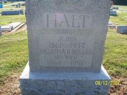
John Halt
| Birth | : | 8 Mar 1861 Patricksburg, Owen County, Indiana, USA |
| Death | : | 15 Feb 1937 Perry Township, Clay County, Indiana, USA |
| Burial | : | Halse Road Cemetery, Brackley, South Northamptonshire Borough, England |
| Coordinate | : | 52.0395310, -1.1494450 |
| Description | : | Shares stone witrh wife Melvina (Miller) Halt. Is buried next to reletives Jown W. and Kenneth O. Halt, both died in 1918. |
frequently asked questions (FAQ):
-
Where is John Halt's memorial?
John Halt's memorial is located at: Halse Road Cemetery, Brackley, South Northamptonshire Borough, England.
-
When did John Halt death?
John Halt death on 15 Feb 1937 in Perry Township, Clay County, Indiana, USA
-
Where are the coordinates of the John Halt's memorial?
Latitude: 52.0395310
Longitude: -1.1494450
Family Members:
Spouse

Children
Flowers:


Nearby Cemetories:
1. Halse Road Cemetery
Brackley, South Northamptonshire Borough, England
Coordinate: 52.0395310, -1.1494450
2. St. Peter's Churchyard
Brackley, South Northamptonshire Borough, England
Coordinate: 52.0309710, -1.1390480
3. Hospital of St James and St John
Brackley, South Northamptonshire Borough, England
Coordinate: 52.0284000, -1.1473000
4. St. Mary's Churchyard
Turweston, Aylesbury Vale District, England
Coordinate: 52.0345400, -1.1257500
5. Holy Trinity Church
Hinton-in-the-Hedges, South Northamptonshire Borough, England
Coordinate: 52.0281190, -1.1881330
6. St. Augustine's Churchyard
Westbury, Aylesbury Vale District, England
Coordinate: 52.0154200, -1.0941150
7. Mixbury All Saints Churchyard
Mixbury, Cherwell District, England
Coordinate: 52.0010100, -1.1131800
8. St. Mary Magdalene's Churchyard
Helmdon, South Northamptonshire Borough, England
Coordinate: 52.0838310, -1.1404000
9. Biddlesden Abbey
Harringworth, East Northamptonshire Borough, England
Coordinate: 52.0539000, -1.0797000
10. St. Margaret's Churchyard
Biddlesden, Aylesbury Vale District, England
Coordinate: 52.0535450, -1.0782870
11. St. Peter's Churchyard
Greatworth, South Northamptonshire Borough, England
Coordinate: 52.0770540, -1.1954490
12. Croughton Cemetery
Croughton, South Northamptonshire Borough, England
Coordinate: 52.0014880, -1.2031960
13. St. Edward the Confessor Churchyard
Shalstone, Aylesbury Vale District, England
Coordinate: 52.0225079, -1.0666653
14. All Saints Churchyard
Croughton, South Northamptonshire Borough, England
Coordinate: 51.9977370, -1.2065760
15. St. Lawrence Churchyard
Marston St Lawrence, South Northamptonshire Borough, England
Coordinate: 52.0744570, -1.2190630
16. Newbottle and Charlton Cemetery
Newbottle, South Northamptonshire Borough, England
Coordinate: 52.0225300, -1.2351200
17. Saint James' Churchyard
Newbottle, South Northamptonshire Borough, England
Coordinate: 52.0280500, -1.2382170
18. St. Mary's Churchyard
Cottisford, Cherwell District, England
Coordinate: 51.9749070, -1.1464410
19. St. Giles' Churchyard
Water Stratford, Aylesbury Vale District, England
Coordinate: 52.0136475, -1.0515046
20. St. Michael and All Angels
Finmere, Cherwell District, England
Coordinate: 51.9931740, -1.0740240
21. St Mary the Virgin Churchyard
Thenford, South Northamptonshire Borough, England
Coordinate: 52.0697510, -1.2442930
22. St. James the Less Churchyard
Sulgrave, South Northamptonshire Borough, England
Coordinate: 52.1036130, -1.1883880
23. St. Mary the Virgin Churchyard
Wappenham, South Northamptonshire Borough, England
Coordinate: 52.1057700, -1.0890570
24. St Michael & All Angels Churchyard
Newton Purcell, Cherwell District, England
Coordinate: 51.9723110, -1.0915630