
| Memorials | : | 1 |
| Location | : | Brackley, South Northamptonshire Borough, England |
| Coordinate | : | 52.0284000, -1.1473000 |
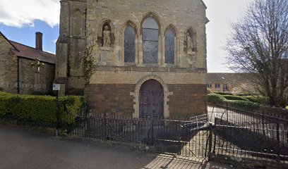
| Description | : | About the year 1150, Robert le Bossu, 2nd Earl of Leicester, gave to one Solomon, a clerk, an acre of land at Brackley whereon to build a house for showing hospitality to the poor, together with a free chapel and graveyard. His son, Robert Blanchmaines, earl of Leicester, granted 2½ acres adjoining the site of the house and other lands exempt from tolls and dues within the parish of Brackley. The house and chapel were dedicated in honour of St. John the Evangelist, but afterwards re-dedicated in honour of Ss James and John. In 1484, the patron, Viscount... Read More |
frequently asked questions (FAQ):
-
Where is Hospital of St James and St John?
Hospital of St James and St John is located at Waynflete Avenue Brackley, South Northamptonshire Borough ,Northamptonshire , NN13 6FBEngland.
-
Hospital of St James and St John cemetery's updated grave count on graveviews.com?
1 memorials
-
Where are the coordinates of the Hospital of St James and St John?
Latitude: 52.0284000
Longitude: -1.1473000
Nearby Cemetories:
1. St. Peter's Churchyard
Brackley, South Northamptonshire Borough, England
Coordinate: 52.0309710, -1.1390480
2. Halse Road Cemetery
Brackley, South Northamptonshire Borough, England
Coordinate: 52.0395310, -1.1494450
3. St. Mary's Churchyard
Turweston, Aylesbury Vale District, England
Coordinate: 52.0345400, -1.1257500
4. Holy Trinity Church
Hinton-in-the-Hedges, South Northamptonshire Borough, England
Coordinate: 52.0281190, -1.1881330
5. Mixbury All Saints Churchyard
Mixbury, Cherwell District, England
Coordinate: 52.0010100, -1.1131800
6. St. Augustine's Churchyard
Westbury, Aylesbury Vale District, England
Coordinate: 52.0154200, -1.0941150
7. Croughton Cemetery
Croughton, South Northamptonshire Borough, England
Coordinate: 52.0014880, -1.2031960
8. All Saints Churchyard
Croughton, South Northamptonshire Borough, England
Coordinate: 51.9977370, -1.2065760
9. Biddlesden Abbey
Harringworth, East Northamptonshire Borough, England
Coordinate: 52.0539000, -1.0797000
10. St. Margaret's Churchyard
Biddlesden, Aylesbury Vale District, England
Coordinate: 52.0535450, -1.0782870
11. St. Edward the Confessor Churchyard
Shalstone, Aylesbury Vale District, England
Coordinate: 52.0225079, -1.0666653
12. St. Mary's Churchyard
Cottisford, Cherwell District, England
Coordinate: 51.9749070, -1.1464410
13. Newbottle and Charlton Cemetery
Newbottle, South Northamptonshire Borough, England
Coordinate: 52.0225300, -1.2351200
14. St. Mary Magdalene's Churchyard
Helmdon, South Northamptonshire Borough, England
Coordinate: 52.0838310, -1.1404000
15. Saint James' Churchyard
Newbottle, South Northamptonshire Borough, England
Coordinate: 52.0280500, -1.2382170
16. St. Peter's Churchyard
Greatworth, South Northamptonshire Borough, England
Coordinate: 52.0770540, -1.1954490
17. St. Michael and All Angels
Finmere, Cherwell District, England
Coordinate: 51.9931740, -1.0740240
18. St. Giles' Churchyard
Water Stratford, Aylesbury Vale District, England
Coordinate: 52.0136475, -1.0515046
19. St. Lawrence Churchyard
Marston St Lawrence, South Northamptonshire Borough, England
Coordinate: 52.0744570, -1.2190630
20. St Michael & All Angels Churchyard
Newton Purcell, Cherwell District, England
Coordinate: 51.9723110, -1.0915630
21. Holy Trinity Churchyard
Hethe, Cherwell District, England
Coordinate: 51.9615600, -1.1452100
22. St Mary the Virgin Churchyard
Hardwick, Cherwell District, England
Coordinate: 51.9616750, -1.1615570
23. St. Edmund and St. George Churchyard
Hethe, Cherwell District, England
Coordinate: 51.9604830, -1.1384690
24. Tingewick Cemetery
Tingewick, Aylesbury Vale District, England
Coordinate: 51.9917800, -1.0514420