| Memorials | : | 0 |
| Location | : | Hinton-in-the-Hedges, South Northamptonshire Borough, England |
| Coordinate | : | 52.0281190, -1.1881330 |
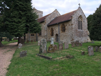
| Description | : | Hinton-in-the-Hedges is a small village and civil parish in South Northamptonshire, due west of the town of Brackley. At the time of the 2001 census, the parish's population was 179 people. There has been a Church in Hinton since Saxon times with Rectors identified from Sir Richard de Hynton in 1275. The church building is an ancient structure, in the Norman style, and contains a monument with the recumbent effigies of a knight and his lady, said to represent Lord and Lady Lovell, of whose manor or castle some remains may still be traced in a meadow near the... Read More |
frequently asked questions (FAQ):
-
Where is Holy Trinity Church?
Holy Trinity Church is located at Hinton-in-the-Hedges, South Northamptonshire Borough ,Northamptonshire , NN13 5NFEngland.
-
Holy Trinity Church cemetery's updated grave count on graveviews.com?
0 memorials
-
Where are the coordinates of the Holy Trinity Church?
Latitude: 52.0281190
Longitude: -1.1881330
Nearby Cemetories:
1. Hospital of St James and St John
Brackley, South Northamptonshire Borough, England
Coordinate: 52.0284000, -1.1473000
2. Halse Road Cemetery
Brackley, South Northamptonshire Borough, England
Coordinate: 52.0395310, -1.1494450
3. Croughton Cemetery
Croughton, South Northamptonshire Borough, England
Coordinate: 52.0014880, -1.2031960
4. Newbottle and Charlton Cemetery
Newbottle, South Northamptonshire Borough, England
Coordinate: 52.0225300, -1.2351200
5. St. Peter's Churchyard
Brackley, South Northamptonshire Borough, England
Coordinate: 52.0309710, -1.1390480
6. Saint James' Churchyard
Newbottle, South Northamptonshire Borough, England
Coordinate: 52.0280500, -1.2382170
7. All Saints Churchyard
Croughton, South Northamptonshire Borough, England
Coordinate: 51.9977370, -1.2065760
8. St. Mary's Churchyard
Turweston, Aylesbury Vale District, England
Coordinate: 52.0345400, -1.1257500
9. St. Peter's Churchyard
Greatworth, South Northamptonshire Borough, England
Coordinate: 52.0770540, -1.1954490
10. St. Lawrence Churchyard
Marston St Lawrence, South Northamptonshire Borough, England
Coordinate: 52.0744570, -1.2190630
11. St Michael Churchyard
Aynho, South Northamptonshire Borough, England
Coordinate: 51.9936080, -1.2522380
12. Kings Sutton Cemetery
Kings Sutton, South Northamptonshire Borough, England
Coordinate: 52.0151400, -1.2711000
13. Mixbury All Saints Churchyard
Mixbury, Cherwell District, England
Coordinate: 52.0010100, -1.1131800
14. St Mary the Virgin Churchyard
Thenford, South Northamptonshire Borough, England
Coordinate: 52.0697510, -1.2442930
15. Ss Peter and Paul Churchyard
Kings Sutton, South Northamptonshire Borough, England
Coordinate: 52.0212000, -1.2763560
16. St Mary the Virgin Churchyard
Souldern, Cherwell District, England
Coordinate: 51.9808600, -1.2399900
17. St. Mary's Churchyard
Cottisford, Cherwell District, England
Coordinate: 51.9749070, -1.1464410
18. St. Augustine's Churchyard
Westbury, Aylesbury Vale District, England
Coordinate: 52.0154200, -1.0941150
19. St. Mary Magdalene's Churchyard
Helmdon, South Northamptonshire Borough, England
Coordinate: 52.0838310, -1.1404000
20. Middleton Cheney Cemetery
Middleton Cheney, South Northamptonshire Borough, England
Coordinate: 52.0745100, -1.2692900
21. St Mary the Virgin Churchyard
Hardwick, Cherwell District, England
Coordinate: 51.9616750, -1.1615570
22. All Saints Churchyard
Middleton Cheney, South Northamptonshire Borough, England
Coordinate: 52.0741984, -1.2740247
23. Biddlesden Abbey
Harringworth, East Northamptonshire Borough, England
Coordinate: 52.0539000, -1.0797000
24. Holy Trinity Churchyard
Hethe, Cherwell District, England
Coordinate: 51.9615600, -1.1452100

