
| Memorials | : | 0 |
| Location | : | Newton Purcell, Cherwell District, England |
| Coordinate | : | 51.9723110, -1.0915630 |
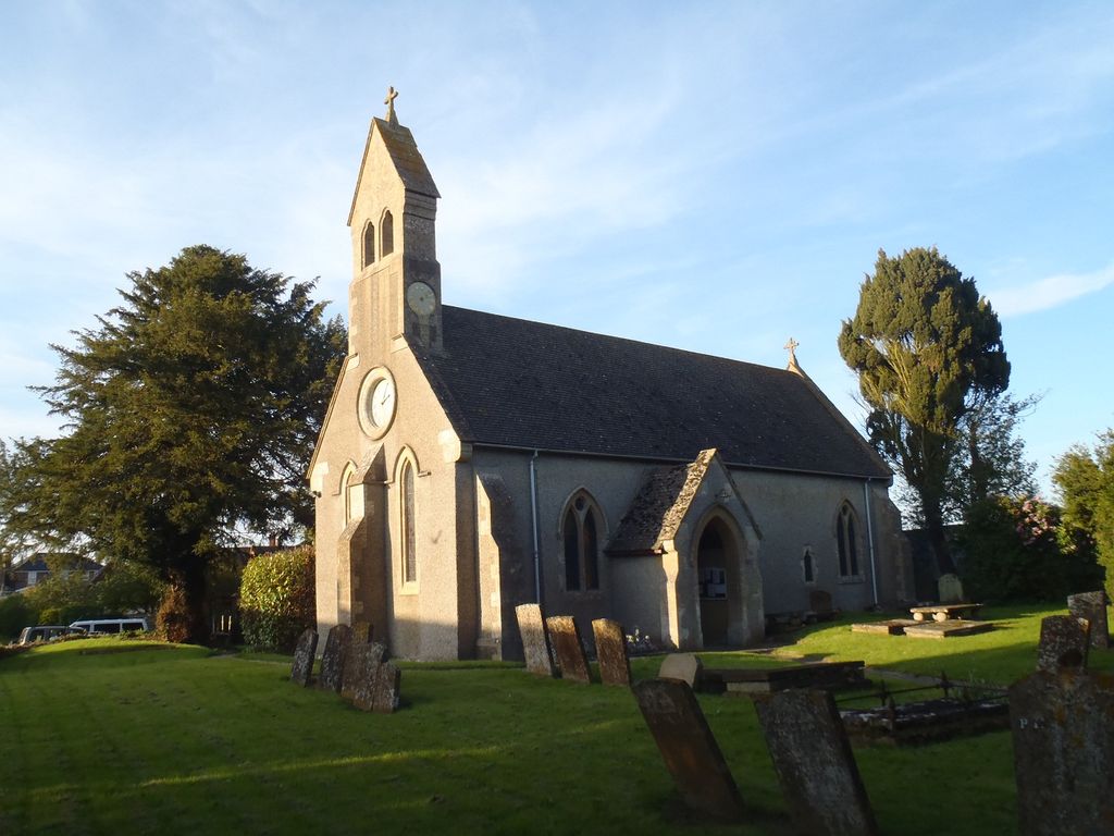
| Description | : | Architectural evidence suggests that the Church of England parish church of Saint Michael and All Angels was built in the Norman style in the middle of the 12th century. The earliest documentary evidence of the church's existence is slightly later, when Ralph Purcel granted the church to the Augustinian Bicester Priory in 1200. Of this original church little survives except a 12th century Norman doorway and a 13th century piscina. In 1813 the church was repaired and most of its original features were destroyed. In 1875 the architect C.N. Beazley restored the building and added the vestry, bell-turret and south... Read More |
frequently asked questions (FAQ):
-
Where is St Michael & All Angels Churchyard?
St Michael & All Angels Churchyard is located at Newton Purcell, Cherwell District ,Oxfordshire , MK18 4AYEngland.
-
St Michael & All Angels Churchyard cemetery's updated grave count on graveviews.com?
0 memorials
-
Where are the coordinates of the St Michael & All Angels Churchyard?
Latitude: 51.9723110
Longitude: -1.0915630
Nearby Cemetories:
1. St James Churchyard
Barton Harthshorn, Aylesbury Vale District, England
Coordinate: 51.9730300, -1.0686650
2. Ss Mary and Nicholas Churchyard
Chetwode, Aylesbury Vale District, England
Coordinate: 51.9630520, -1.0694610
3. St Michaels and All Angels Churchyard
Fringford, Cherwell District, England
Coordinate: 51.9573680, -1.1189880
4. St. Michael and All Angels
Finmere, Cherwell District, England
Coordinate: 51.9931740, -1.0740240
5. St. John the Baptist Churchyard
Preston Bissett, Aylesbury Vale District, England
Coordinate: 51.9637380, -1.0440980
6. Holy Trinity
Godington, Cherwell District, England
Coordinate: 51.9452700, -1.0667470
7. St. Edmund and St. George Churchyard
Hethe, Cherwell District, England
Coordinate: 51.9604830, -1.1384690
8. Tingewick Cemetery
Tingewick, Aylesbury Vale District, England
Coordinate: 51.9917800, -1.0514420
9. Mixbury All Saints Churchyard
Mixbury, Cherwell District, England
Coordinate: 52.0010100, -1.1131800
10. St. Mary's Churchyard
Cottisford, Cherwell District, England
Coordinate: 51.9749070, -1.1464410
11. Holy Trinity Churchyard
Hethe, Cherwell District, England
Coordinate: 51.9615600, -1.1452100
12. St. Mary's Churchyard
Tingewick, Aylesbury Vale District, England
Coordinate: 51.9919690, -1.0432400
13. St. Augustine's Churchyard
Westbury, Aylesbury Vale District, England
Coordinate: 52.0154200, -1.0941150
14. St Mary the Virgin Churchyard
Hardwick, Cherwell District, England
Coordinate: 51.9616750, -1.1615570
15. SS Mary & Edburga Churchyard
Stratton Audley, Cherwell District, England
Coordinate: 51.9294810, -1.1164160
16. St. Giles' Churchyard
Water Stratford, Aylesbury Vale District, England
Coordinate: 52.0136475, -1.0515046
17. Holy Trinity Churchyard
Gawcott-with-Lenborough, Aylesbury Vale District, England
Coordinate: 51.9809000, -1.0114000
18. Assumption of BVM Churchyard
Twyford, Aylesbury Vale District, England
Coordinate: 51.9345860, -1.0341060
19. St. Edward the Confessor Churchyard
Shalstone, Aylesbury Vale District, England
Coordinate: 52.0225079, -1.0666653
20. Saint John the Evangelist Churchyard
Buckingham, Aylesbury Vale District, England
Coordinate: 51.9996500, -1.0174090
21. All Saints Churchyard
Hillesden, Aylesbury Vale District, England
Coordinate: 51.9582028, -1.0045972
22. St Peters Churchyard
Stoke Lyne, Cherwell District, England
Coordinate: 51.9505340, -1.1771680
23. St Laurence Churchyard
Caversfield, Cherwell District, England
Coordinate: 51.9223030, -1.1571690
24. Church of the Assumption of Blessed Virgin Mary
Stowe, Aylesbury Vale District, England
Coordinate: 52.0182720, -1.0174270